
Strip mall on Rothesay at Kingsford
- i04659
- Item
- [197-?]
Springfield Heights Value Centre strip mall on Rothesay Street near Kingsford Avenue. Businesses include a barber shop, a pharmacy, Kwik Shop, and Penner’s Food.
957 results with digital objects Show results with digital objects
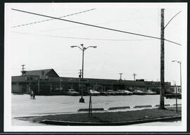
Strip mall on Rothesay at Kingsford
Springfield Heights Value Centre strip mall on Rothesay Street near Kingsford Avenue. Businesses include a barber shop, a pharmacy, Kwik Shop, and Penner’s Food.

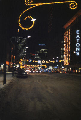
Christmas lights along Portage, looking west from Donald
Christmas lights along Portage Avenue, looking west from around Donald Street. The Eaton’s Department Store is lit up on the left.
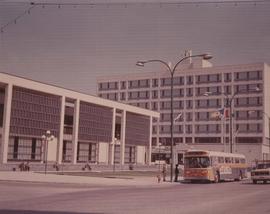
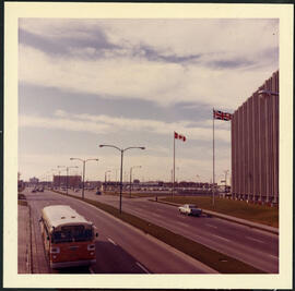
A photograph of the Civic Centre Complex, Winnipeg's third city hall (1964-present). Council Building, Administration Building, and public transit bus in view. Taken from William Avenue and Main Street, looking northwest. Date of photograph is uncertain, [197-?]. The photographer is likely Henry Kalen.
Kalen, Henry
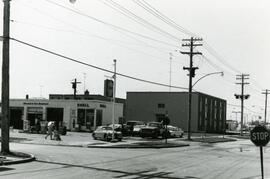
7-Eleven at the corner of Rothesay and Kingsford
Photograph of a 7-Eleven store at the corner of Rothesay Street and Kingsford Avenue.
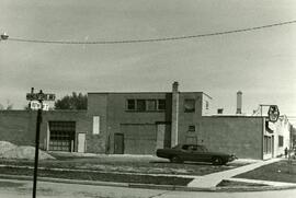
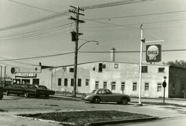
Shell station on Rothesay Street near Kingsford
Shell Service Station at the corner of Rothesay Street and Kingsford Avenue.
Shell station on Rothesay Street near Kingsford
Shell Service Station at the corner of Rothesay Street and Kingsford Avenue.
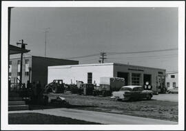
7-eleven and Shell station on Rothesay between Edison and Kingsford
7-Eleven store and sign of Shell Service Station on Rothesay Street between Edison and Kingsford Avenues.
Portage Avenue looking west from Empress Street
Portage Avenue in front of Manitoba Telephone Systems building on Empress Street, looking west.
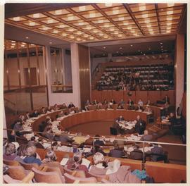
A photograph of City Council in session. Interior shot of Winnipeg's third City Hall (built 1964). Council Chambers and seated Councillors in view. At this time, Council included 50 Councillors. Photographer's stamp on verso. Date of photograph is 1972.
Allan, Hugh
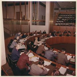
A photograph of City Council in session. Interior shot of Winnipeg's third City Hall (built 1964). Council Chambers and seated Councillors in view. Photographer's stamp on verso. Date of photograph is 1972.
Allan, Hugh
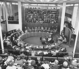
Inaugural Meeting of Council (first council meeting of Unicity)
Photograph documents the Inaugural Meeting of Council (first council meeting of Unicity), held Tuesday, January 4th, 1972, 2:00 pm (Council Chambers, Winnipeg City Hall).
Allan, Hugh
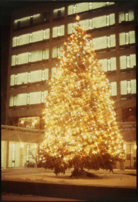
Photographs of the Christmas Tree at City Hall.
Christmas lights along Portage Avenue and Main Street
Christmas lights lit up along Portage Avenue, looking east towards Main Street, from about Carlton Street. Eaton’s Department Store is lit up on the right and the Royal Bank and Richardson buildings are lit in the distance.
Christmas lights along Portage, looking east from Carlton
Christmas lights along Portage Avenue, looking east from around Carlton Street. The Eaton’s Department Store is lit up on the right and the Richardson and Royal Bank buildings are lit in the distance.

Aerial of 1974 Flood – Red River between East and West Kildonan
Aerial photograph of the Red River during the 1974 Flood. The photograph faces northwest from around Helmsdale Avenue and Kildonan Drive in East Kildonan towards Scotia Street in the Seven Oaks area of West Kildonan across the river. The photographs were taken by the Department of Environmental Planning.
Winnipeg (Man.). Department of Environmental Planning

Aerial of 1974 Flood – Pritchard Avenue Boat Dock and Redwood Bridge
Aerial photograph of the Red River during the 1974 Flood. The photograph faces northwest towards the North End, with the Pritchard Avenue Boat Dock in the bottom left and the Redwood Bridge in the top right. The photographs were taken by the Department of Environmental Planning.
Winnipeg (Man.). Department of Environmental Planning

Aerial of 1974 Flood – Fraser’s Grove Park
Aerial photograph of the Red River during the 1974 Flood. The photograph faces southwest from Fraser’s Grove Park and Kildonan Drive in East Kildonan towards Scotia Street in the Seven Oaks area of West Kildonan. The photographs were taken by the Department of Environmental Planning.
Winnipeg (Man.). Department of Environmental Planning

Aerial of 1974 Flood – Bergen Cutoff Bridge
Aerial photograph of the Bergen Cutoff Bridge during the 1974 Flood. The photograph faces northwest from Kildonan Drive in North Kildonan across the Red River towards Kildonan Park and Old Kildonan. The photographs were taken by the Department of Environmental Planning.
Winnipeg (Man.). Department of Environmental Planning
Monty Hall at the Folklorama Kiev Pavilion
Monty Hall posing for a photograph at the Folklorama’s Kiev / Ukrainian Pavilion.