
- i01462
- Item
- [194-?]
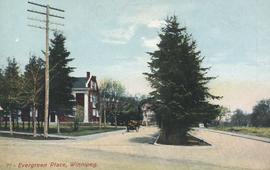
Postcard includes message from Tab to Beat? on verso. Published by C. S. Co. Ltd., Winnipeg, printed in Saxony.
80 results with digital objects Show results with digital objects
Postcard includes message from Tab to Beat? on verso. Published by C. S. Co. Ltd., Winnipeg, printed in Saxony.
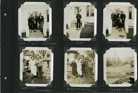
Scrapbook of Corporal Wallace – page 3
Page 3 of a photograph scrapbook made by Corporal John Wallace in April 1940. Photographs depict two families acquainted with Wallace: the Butlers (Jim Sr., Jim Jr., Les, Aggie, Gig, and Mrs. Butler) and the Drinkwaters (Mr. and Mrs. Drinkwater, Joan, Hilda, and Les), as well as Gladstone Manitoba. See general notes section for more details.
Wallace, John
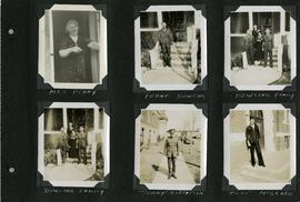
Scrapbook of Corporal Wallace – page 5
Page 5 of a photograph scrapbook made by Corporal John Wallace in April 1940. Photographs depict several acquaintenance of Wallace including two fellow soldiers, “Sonny” Robertson and Joseph “Fuss” McGrath, a Mrs. Penny, and a Frank Dowling and his family. See the general notes section for more details.
Wallace, John

Wildwood Park - Three weeks before flood, 1950

Wildwood Park - Three weeks before flood, 1950
Wildwood Park - Three weeks before flood, 1950

Sandbags on the dyke (Wildwood Park - flood, 1950)
![Sandbags - E sec [section] (Wildwood Park - flood, 1950)](/uploads/r/city-of-winnipeg-archives-amp-records-control-branch/c/4/a/c4a7e5ee657f2cf565da1e983d41beae65af0b67f4b9fb5fa71c540b99003de4/C0013_0000_0000_P0022_0094_001_142.jpg)
Sandbags - E sec [section] (Wildwood Park - flood, 1950)
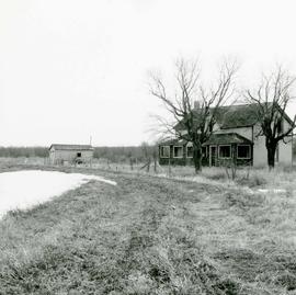
Area of John Blumberg Golf Course prior to construction.
Photograph of abandoned buildings on a rural stretch of land in the area of what is now John Blumberg Golf Course. A description of the photo used for publication is recorded on a separate piece of paper. Photo's reverse is stamped by the Parks and Protection Division of the Metro Government.
Metropolitan Corporation of Greater Winnipeg (Man.). Information Officer

Apartment block at 415 Edison Avenue
Apartment block at 415 Edison Avenue, near Rothesay Street.

Aerial of 1974 Flood – Red River between East and West Kildonan
Aerial photograph of the Red River during the 1974 Flood. The photograph faces northwest from around Helmsdale Avenue and Kildonan Drive in East Kildonan towards Scotia Street in the Seven Oaks area of West Kildonan across the river. The photographs were taken by the Department of Environmental Planning.
Winnipeg (Man.). Department of Environmental Planning

Aerial of 1974 Flood – Pritchard Avenue Boat Dock and Redwood Bridge
Aerial photograph of the Red River during the 1974 Flood. The photograph faces northwest towards the North End, with the Pritchard Avenue Boat Dock in the bottom left and the Redwood Bridge in the top right. The photographs were taken by the Department of Environmental Planning.
Winnipeg (Man.). Department of Environmental Planning

Aerial of 1974 Flood – Fraser’s Grove Park
Aerial photograph of the Red River during the 1974 Flood. The photograph faces southwest from Fraser’s Grove Park and Kildonan Drive in East Kildonan towards Scotia Street in the Seven Oaks area of West Kildonan. The photographs were taken by the Department of Environmental Planning.
Winnipeg (Man.). Department of Environmental Planning

Aerial of 1974 Flood – Bergen Cutoff Bridge
Aerial photograph of the Bergen Cutoff Bridge during the 1974 Flood. The photograph faces northwest from Kildonan Drive in North Kildonan across the Red River towards Kildonan Park and Old Kildonan. The photographs were taken by the Department of Environmental Planning.
Winnipeg (Man.). Department of Environmental Planning

Aerial of 1974 Flood – Red River between North and West Kildonan
Aerial photograph of the Red River during the 1974 Flood. The photograph faces west from North Kildonan, where the Chief Peguis Trail now stands, across the river towards Kildonan Park and West Kildonan on the left, the North End Water Treatment Plant in the middle, and Old Kildonan on the right. The photographs were taken by the Department of Environmental Planning.
Winnipeg (Man.). Department of Environmental Planning

Part of City of Winnipeg (1874-1971)
A photograph of flooding in a residential area of Winnipeg during the 1950 flood. The photograph was taken at the intersection of Disraeli and Euclid.
Harold K. White Studio

Part of City of Winnipeg (1874-1971)
A photograph of high water surrounding a causeway that ran to the Rover Street hydro station during the 1950 flood.
Harold K. White Studio

Part of City of Winnipeg (1874-1971)
A photograph of flooding on Disraeli St during the 1950 flood. The photograph shows a child standing on a pile of lumber beside the flooded street.
Harold K. White Studio

Gladstone Street from Sutherland Avenue
Part of City of Winnipeg (1874-1971)
A photograph of flooding on Gladstone Street during the 1950 flood in Winnipeg. The photograph was taken from Sutherland Avenue.
Harold K. White Studio

Causeway to Rover Street Station
Part of City of Winnipeg (1874-1971)
A photograph of high water surrounding a causeway that ran to the Rover Street hydro station during the 1950 flood.
Harold K. White Studio