A photograph taken during the 1950 flood, showing the southeast corner of Arnold Avenue and possibly 100 Arnold Avenue. Item is 7 of 8 photographs on page 1 of scrapbook.
A photograph taken during the 1950 flood, showing 84 Arnold Avenue, 86 Arnold Avenue, 88 Arnold Avenue Item is 3 of 8 photographs on page 2 of scrapbook.
Subseries consists of a scrapbook assembled by the City Engineering Department to serve as photographic evidence of the 1950 flood. It contains black and white photographs that mostly document flooding in residential areas near the Red River (Fort Rouge, Riverview, North End, Point Douglas, Crescentwood, Armstrong's Point and others). Scrapbook appears to be organized geographically by area and street. In addition to documenting flooding, the photographs provide a detailed record of residential neighbourhoods, houses, streets, and businesses like corner grocery stores and laundries. All photographs were taken by Harold K. White Studio.
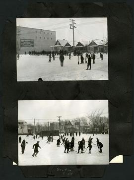
Two photographs of children playing hockey on outdoor skating rinks. Photo at top was taken outside the Northland Knitting Company building at 618 Arlington Street. Photo at bottom was taken on Scotia Street, near Luxton Avenue. The photographs are affixed to one side of a piece of construction paper that has two other photos on its reverse.
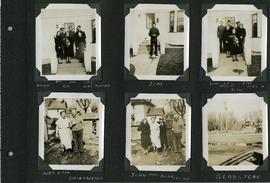
Page 3 of a photograph scrapbook made by Corporal John Wallace in April 1940. Photographs depict two families acquainted with Wallace: the Butlers (Jim Sr., Jim Jr., Les, Aggie, Gig, and Mrs. Butler) and the Drinkwaters (Mr. and Mrs. Drinkwater, Joan, Hilda, and Les), as well as Gladstone Manitoba. See general notes section for more details.
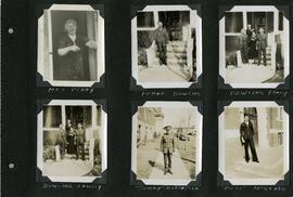
Page 5 of a photograph scrapbook made by Corporal John Wallace in April 1940. Photographs depict several acquaintenance of Wallace including two fellow soldiers, “Sonny” Robertson and Joseph “Fuss” McGrath, a Mrs. Penny, and a Frank Dowling and his family. See the general notes section for more details.
Aerial photograph of the Red River during the 1974 Flood. The photograph faces northwest towards the North End, with the Pritchard Avenue Boat Dock in the bottom left and the Redwood Bridge in the top right. The photographs were taken by the Department of Environmental Planning.
Winnipeg (Man.). Department of Environmental Planning
Aerial photograph of the Red River during the 1974 Flood. The photograph faces southwest from Fraser’s Grove Park and Kildonan Drive in East Kildonan towards Scotia Street in the Seven Oaks area of West Kildonan. The photographs were taken by the Department of Environmental Planning.
Winnipeg (Man.). Department of Environmental Planning
Aerial photograph of the Red River during the 1974 Flood. The photograph faces northwest from around Helmsdale Avenue and Kildonan Drive in East Kildonan towards Scotia Street in the Seven Oaks area of West Kildonan across the river. The photographs were taken by the Department of Environmental Planning.
Winnipeg (Man.). Department of Environmental Planning
Aerial photograph of the Bergen Cutoff Bridge during the 1974 Flood. The photograph faces northwest from Kildonan Drive in North Kildonan across the Red River towards Kildonan Park and Old Kildonan. The photographs were taken by the Department of Environmental Planning.
Winnipeg (Man.). Department of Environmental Planning