

Winnipeg, Main Street looking south, Summer 1875
- i00033
- Item
- 1875
Part of City of Winnipeg (1874-1971)
Photograph taken from top of Courthouse.
144 results with digital objects Show results with digital objects
Winnipeg, Main Street looking south, Summer 1875
Part of City of Winnipeg (1874-1971)
Photograph taken from top of Courthouse.

Part of City of Winnipeg (1874-1971)
Photograph shows the North End Farmer's Market (west side Main Street, north of Stella Avenue, looking west to King Street). Included in photograph: front entrance to market, automobiles parked on street, and North End Horse Exchange (523 King Street). Photograph likely taken from 919-921 Main Street by city employee.

Part of City of Winnipeg (1874-1971)
Photograph shows the North End Farmer's Market, looking east across Main Street (northwest Main Street and Stella Avenue). Included in photograph: stalls filled with vegetables and people walking through the market, Aime Bicycle Shop, 909 Main Street, two-storey brick building (899-905 Main Street), and Norquay School.

Part of City of Winnipeg (1874-1971)
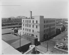
Photograph of the Winnipeg Renovating Co. on Lombard Avenue. Item is part of small album containing photographs of maps tracking the outbreak of typhoid from 1905 to 1908 and other scenes. Item is loose and at back of album. Date of item is approximate, [circa 1909].

Part of City of Winnipeg (1874-1971)
Photograph of the Winnipeg Renovating Co. and the Grain Exchange on Lombard Avenue. Item is part of small album containing photographs of maps tracking the outbreak of typhoid from 1905 to 1908 and other scenes. Item is loose and at back of album. Date of item is approximate, [circa 1909].

North side of Lombard, Rorie to Main Street
Part of City of Winnipeg (1874-1971)
A photograph of storefronts and advertisements on the north side of Lombard Avenue, between Rorie Street and Main Street. The photograph is part of small album containing photographs of maps tracking the outbreak of typhoid from 1905 to 1909 and other scenes. Item is loose and at back of album.

City Hall and courtyard, facing Market Avenue
Photograph of the front side of Winnipeg's second City Hall, facing towards Market Avenue. Also featured in the photograph is the green space in front of City Hall, the Jubilee Fountain, the Volunteer Monument, businesses and store fronts on Market Avenue, and the McLaren and Cornwall Hotels in the distance. Photographed by Henry Kalen.
Metropolitan Corporation of Greater Winnipeg (Man.). Information Officer

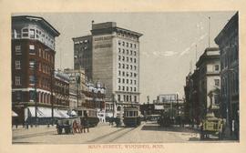
Main Street looking north from Portage Avenue
Part of City of Winnipeg (1874-1971)
Bentley Building, Courthouse and Artesian well shown in photograph.
William Smaill Photo Album – Page 20
Part of William Smaill fonds
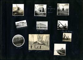
Captions read: Mile 85 - Old Fort Garry and hotel - Fort Garry apartments - Hudson's Bay stores, Winnipeg - Bay City dredge - Whitemouth, April 1914 - W.G. Chas, J.H. Fuertes [?], A. C.H. Blanchard [?] - Mile 57.
Smaill, William

Page shows five street views of Winnipeg, ca. 1903: 1) Main Street from Commercial Club, 2) Elgin Avenue, 3) Geo. Velie, Wholesale Wines and Liquors, 4) William Avenue, looking west, and 5) Main Street, looking north from Portage Avenue.
Photograph shows Dufferin Avenue, east of the Arlington Bridge, in background. Date of photograph is approximate, ca. 1936.
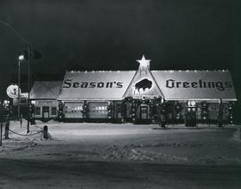
Prairies Cities Oil Service Station, Graham and Fort
Date of photograph is approximate, ca. 1937.
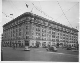
Hudson's Bay Company Store from Portage Avenue at Memorial Boulevard
Date of photograph is approximate, ca. 1942.
Date of photograph is uncertain, [before 1949].
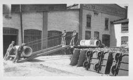
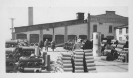
Men loading concrete forms onto truck
One of the men shown in photograph identified as Frank Richards. Wood's Brick Company Ltd. building visible in background. Date of photograph is uncertain, [before 1949].

Southeast corner of back lane, north side of Market Avenue and Main Street, circa 1941
Photograph shows present site of the Centennial Concert Hall. Cristall's Mens Outfitters and Klasser's Mail Order House visible in photograph.
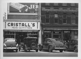
Southeast corner of back lane, north side of Market Avenue and Main Street, circa 1941
Photograph shows present site of the Centennial Concert Hall. Cristall's Mens Outfitters visible in photograph.
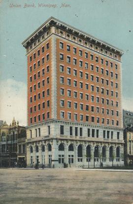
Postcard shows Union Bank Building, view from the corner of Market Avenue and Main Street. Date of postcard is uncertain, [before 1949].
Postcard shows Main Street looking north from McDermot Avenue to Union Bank Building. Date of postcard is uncertain, [before 1949].
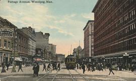
Portage Avenue, Winnipeg, Man.
Postcard shows view from Portage Avenue and Hargrave Street. The T. Eaton Co. Ltd. department store is shown at right; Clarendon Hotel is shown at left. Date of postcard is uncertain, [before 1949].