

Pontoon Bridge, Fort Garry and Warehouse from south side Assiniboine River
- i00040
- Item
- 1874
Part of City of Winnipeg (1874-1971)
177 results with digital objects Show results with digital objects
Pontoon Bridge, Fort Garry and Warehouse from south side Assiniboine River
Part of City of Winnipeg (1874-1971)

Main Street looking north from Portage Avenue
Part of City of Winnipeg (1874-1971)
Bentley Building, Courthouse and Artesian well shown in photograph.

Winnipeg, Main Street looking south, Spring of 1874
Part of City of Winnipeg (1874-1971)
Photograph taken from top of Courthouse.

Winnipeg, Main Street looking south, Summer 1875
Part of City of Winnipeg (1874-1971)
Photograph taken from top of Courthouse.

Point Douglas from Courthouse, 1874
Part of City of Winnipeg (1874-1971)
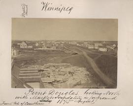
Point Douglas looking north with City Hall foundation in foreground, August 1875
Part of City of Winnipeg (1874-1971)
Photograph taken from top of Courthouse.

Part of East Ward, St. Boniface in the distance
Part of City of Winnipeg (1874-1971)
Photograph taken from top of Courthouse.

Part of City of Winnipeg (1874-1971)
Photograph shows the North End Farmer's Market, looking east across Main Street (northwest Main Street and Stella Avenue). Included in photograph: stalls filled with vegetables and people walking through the market, Aime Bicycle Shop, 909 Main Street, two-storey brick building (899-905 Main Street), and Norquay School.

Part of City of Winnipeg (1874-1971)
Photograph shows the North End Farmer's Market (west side Main Street, north of Stella Avenue, looking west to King Street). Included in photograph: front entrance to market, automobiles parked on street, and North End Horse Exchange (523 King Street). Photograph likely taken from 919-921 Main Street by city employee.
Arthur and Fred Landen photograph album – page 32
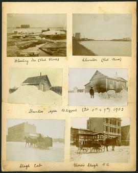
Page 32 of a photograph album created by brothers Arthur and Fred Landen of Hull, England. Page consists of 6 photographs taken by Fred Landen depicting, clockwise from top-left: ice floating on the Red River; a grain elevator on the banks of the Red River; a house buried in snow after the blizzard on February 8 and 9, 1905; a horse-drawn delivery sleigh from Imperial Dry Goods on Main Street in front of the old post office and the Conklins Land Office; a horse-drawn sleigh cab possibly outside the Assiniboine Block/Empire Hotel on Main Street; and another small house buried in snow after the blizzard on February 8 and 9, 1905.
Landen, Frederick Cluett
Arthur and Fred Landen photograph album – page 30
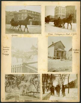
Page 30 of a photograph album created by brothers Arthur and Fred Landen of Hull, England. Page consists of 6 photographs taken by Fred Landen depicting, clockwise from top-left: A horse-drawn “speeder” sleigh in front of the Nares Building on Main Street and Lombard Avenue; a horse-drawn toboggan in front of the old post office on Main Street and McDermot Avenue; a workman’s house; children standing in winter clothes in a residential neighbourhood; Fred Landen sitting in wooded area, “The Grove” in “Kildonia” [Kildonan] - likely Fraser's Grove in East Kildonan; and a horse and buggy in a residential neighbourhood.
Landen, Frederick Cluett
Arthur and Fred Landen photograph album – page 29
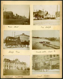
Page 29 of a photograph album created by brothers Arthur and Fred Landen of Hull, England. Page consists of 6 photographs taken by Fred Landen depicting, clockwise from top-left: Main Street facing north from McDermot Avenue; a horse-drawn sleigh carrying a large block of ice in front of the Transit Hotel on Notre Dame Avenue East (now Pioneer Avenue); break-water on the Assiniboine River with houses in the distance; women in sleigh buggy in front of storefronts on Main Street, between Portage and Graham Avenues; the old Manitoba Parliament Building; and a horse-drawn sleigh bus advertising the Vendome Hotel in front of the Commonwealth Block on Main Street and Market Avenue.
Landen, Frederick Cluett

Arthur and Fred Landen photograph album – page 28
Page 28 of a photograph album created by brothers Arthur and Fred Landen of Hull, England. Page consists of 6 photographs taken by Fred Landen depicting, clockwise from top-left: bricklayers in front of houses; women on a horse-drawn sleigh (captioned “Cutter”); police in raccoon-skin uniforms; a streetcar crossing the Osborne Bridge; a Ox-drawn sleigh in front of the Royal Oak Hotel in Market Square (Market Avenue and King Street); and a woman pushing a baby in a sleigh in at the northwest corner of Broadway and Kennedy Street.
Landen, Frederick Cluett

Arthur and Fred Landen photograph album – page 26
Page 26 of a photograph album created by brothers Arthur and Fred Landen of Hull, England. Page consists of 6 photographs taken by Fred Landen depicting, clockwise from top-left: Winnipeg’s second City Hall and the Volunteer Monument (which is captioned “Scott’s Monument, Fish Creek”); the Osborne Bridge over the Assiniboine River; a horse drawn sleigh carrying cords of wood in front of City Hall; a large house on Broadway, a dog sleigh in front of H. Laffrezen's Central Bakery at 333 1/2 William Avenue; and floating ice on the Assiniboine River.
Landen, Frederick Cluett

Aerial view of Point Douglas, St. Boniface, and Elmwood areas
Aerial photograph of Point Douglas, St. Boniface, and west Elmwood.

1932 Relief Works and Committee Winnipeg
Photograph collage of the 1932 Winnipeg Relief Works and Committee. Portraits of committee members are surrounding photographs of projects the committee had worked on. The committee members are, clockwise from top left: Alderman John Blumberg, Alderman H. Andrews, City Clerk Magnus Peterson, Alderman J.A. Barry, Alderman A.A. Ryley, Alderman W.B. Simpson, City Engineer W.P. Brereton, G.W. Northwood, Alderman E.D. Honeyman, Mayor Ralph Webb, Alderman J.A. McKerschar, A. MacNamara, Resident Engineer A.J. Taunton, Alderman L.F. Borrowman, and Alderman C.E. Simonite. The works projects showcased in the center are, clockwise from top left: the Main Street Bridge, the Norwood Bridge, the Assiniboine Park Bridge, the Winnipeg Auditorium, the Sargent Park Swimming Pool, and the Salter Street Bridge. Created by Robson Photo.

Main Street north of Portage Avenue
Photograph of a muddy Main Street in 1872, facing north from Portage Avenue and lined with shops on both sides, including a provisions store on the very right.

Main Street looking northeast to Grace Methodist Church
Photograph of a muddy Main Street in 1871, facing northeast from around St. Mary Avenue. Featured on the photograph's right-hand side is Grace Methodist Church, located at Main Street and Water Avenue (now William Stephenson Way), which was opened on September 17 of that year.
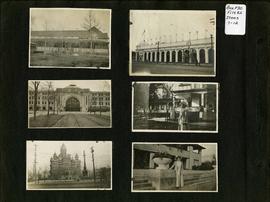
Photograph album of Winnipeg during WW1: Page 2
Item consists of a scrapbook page showing unidentified building (Item 7), Industrial Bureau Exhibition Building (Item 8), Canadian National Railway station (C.N.R. station) from Broadway looking east (Item 9), unidentified woman standing in front of residential building (Item 10), City Hall and Volunteer Monument (second City Hall) (Item 11), unidentified woman posing in front of what is likely the Assiniboine Park Pavilion (Item 12). Dates of photographs are approximate, [ca. 1913].

Photograph album of Winnipeg during WW1: Page 6
Item consists of a scrapbook page showing soldiers marching in military parade on street in front of the Elliott and Hazel Grocers, 975 Main Street and the H. Lindster's Bakery, 971 Main Street (Item 25), soldiers lined up in military parade (Item 26),
soldiers marching in military parade (Item 27), soldiers marching in military parade (Item 28), [ca. 1913].