

- i00131
- Item
- May 15, 1950
Part of City of Winnipeg (1874-1971)
A photograph of high water surrounding a causeway that ran to the Rover Street hydro station during the 1950 flood.
Harold K. White Studio
42 results with digital objects Show results with digital objects
Part of City of Winnipeg (1874-1971)
A photograph of high water surrounding a causeway that ran to the Rover Street hydro station during the 1950 flood.
Harold K. White Studio

Causeway to Rover Street Station
Part of City of Winnipeg (1874-1971)
A photograph of high water surrounding a causeway that ran to the Rover Street hydro station during the 1950 flood.
Harold K. White Studio

Part of City of Winnipeg (1874-1971)
A photograph of three people walking down Sutherland Avenue, near a rock causeway, during the 1950 flood. A boat is in a flooded ditch next to a sandbag dike.
Harold K. White Studio
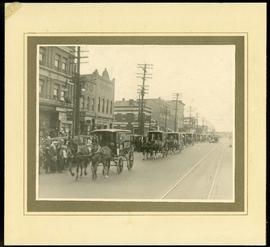
Canada Bread delivery wagons at Main and Selkirk
Part of Morris Block collection
Photograph mounted on cardboard of a cavalcade of Canada Bread horse-drawn delivery wagons riding south down Main Street, at the corner of Selkirk Avenue.
Block, Morris

Beginning of Causeway Sutherland at Disraeli
Part of City of Winnipeg (1874-1971)
A photograph of equipment and vehicles at the beginning of a rock causeway at the intersection of Sutherland Avenue and Disraeli Street during the 1950 flood.
Harold K. White Studio
Back of Brown and Rutherford (Buchanan Street)
Part of City of Winnipeg (1874-1971)
A photograph taken during the 1950 flood, showing Back of Brown and Rutherford (Buchanan Street). Item is 6 of 6 photographs on page 73 of scrapbook.
Harold K. White Studio

Arthur and Fred Landen photograph album – page 31
Page 31 of a photograph album created by brothers Arthur and Fred Landen of Hull, England. Page consists of 6 photographs taken by Fred Landen depicting, clockwise from top-left: shacks in residential area, likely the North End; men lighting a mosquito fire on the banks of the Red River; Fred Landen sitting on the bank of the Red River; a large house with brick veneer; a large house with wood veneer; and a horse-drawn sleigh advertising “A. Hendry. Grocer.” in front of a large house.
Landen, Frederick Cluett

Aerial view of Point Douglas, St. Boniface, and Elmwood areas
Aerial photograph of Point Douglas, St. Boniface, and west Elmwood.

Aerial of 1974 Flood – Pritchard Avenue Boat Dock and Redwood Bridge
Aerial photograph of the Red River during the 1974 Flood. The photograph faces northwest towards the North End, with the Pritchard Avenue Boat Dock in the bottom left and the Redwood Bridge in the top right. The photographs were taken by the Department of Environmental Planning.
Winnipeg (Man.). Department of Environmental Planning
Part of City of Winnipeg (1874-1971)
A photograph taken during the 1950 flood, showing 99 Matheson Avenue and 103 Matheson Avenue. Item is 5 of 6 photographs on page 42 of scrapbook.
Harold K. White Studio
Part of City of Winnipeg (1874-1971)
A photograph taken during the 1950 flood, showing 96 Barber Street. Item is 5 of 5 photographs on page 58 of scrapbook.
Harold K. White Studio
Part of City of Winnipeg (1874-1971)
A photograph taken during the 1950 flood, showing 96 Matheson Avenue and 98 Matheson Avenue. Item is 7 of 8 photographs on page 40 of scrapbook.
Harold K. White Studio
95, 99 and 101 Disraeli Street
Part of City of Winnipeg (1874-1971)
A photograph taken during the 1950 flood, showing 95 Disraeli Street and 99 Disraeli Street and 101 Disraeli Street. Item is 5 of 6 photographs on page 62 of scrapbook.
Harold K. White Studio
Part of City of Winnipeg (1874-1971)
A photograph taken during the 1950 flood, showing 94 McAdam Avenue. Item is 6 of 6 photographs on page 38 of scrapbook.
Harold K. White Studio
Part of City of Winnipeg (1874-1971)
A photograph taken during the 1950 flood, showing 93 Matheson Avenue and 97 Matheson Avenue. Item is 4 of 6 photographs on page 42 of scrapbook.
Harold K. White Studio
Part of City of Winnipeg (1874-1971)
A photograph taken during the 1950 flood, showing 93 McAdam Avenue and 95 McAdam Avenue. Item is 5 of 5 photographs on page 36 of scrapbook.
Harold K. White Studio
Part of City of Winnipeg (1874-1971)
A photograph taken during the 1950 flood, showing 90 Matheson Avenue and 92 Matheson Avenue and 94 Matheson Avenue. Item is 6 of 8 photographs on page 40 of scrapbook.
Harold K. White Studio
Part of City of Winnipeg (1874-1971)
A photograph taken during the 1950 flood, showing 90 Grove Street and 92 Grove Street. Item is 8 of 8 photographs on page 59 of scrapbook.
Harold K. White Studio
Part of City of Winnipeg (1874-1971)
A photograph taken during the 1950 flood, showing 9 Bannerman Avenue and 11 Bannerman Avenue and 18 Bannerman Avenue. Item is 3 of 7 photographs on page 48 of scrapbook.
Harold K. White Studio
Part of City of Winnipeg (1874-1971)
A photograph taken during the 1950 flood, showing 9 Rover Street. Item is 2 of 8 photographs on page 76 of scrapbook.
Harold K. White Studio