
- i04975
- Item
- 5 Aug. 1952
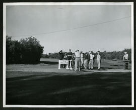
A photo of a man golfing with a group of onlookers in Kildonan Golf Course.
Winnipeg (Man.). Board of Parks and Recreation
47 results with digital objects Show results with digital objects
A photo of a man golfing with a group of onlookers in Kildonan Golf Course.
Winnipeg (Man.). Board of Parks and Recreation
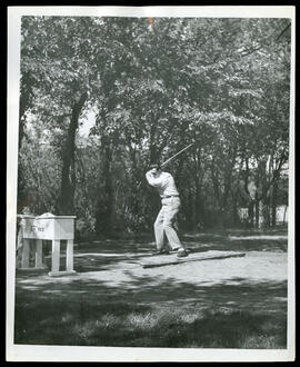
A man driving a golf ball on the Kildonan Park Golf Course
A photo of a man driving a golf ball at the 15th tee on the Kildonan Golf Course.
Winnipeg (Man.). Board of Parks and Recreation
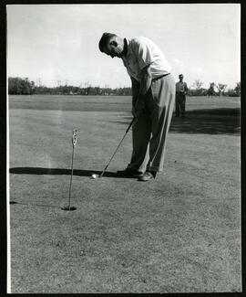
A man putting a golf ball on the Kildonan Park Golf Course
A photo of a man putting a golf ball at the fifth tee, another man watches in the distance at Kildonan Golf Course.
Winnipeg (Man.). Board of Parks and Recreation

A man putting a golf ball on the Kildonan Park Golf Course
A photo of a man putting a golf ball at the Kildonan Park Golf Course.
Winnipeg (Man.). Board of Parks and Recreation

Old Kildonan Park Pavilion in winter
A photograph of the old Kildonan Park Pavilion in the winter. The photographer is unknown.
Metropolitan Corporation of Greater Winnipeg (Man.). Information Officer
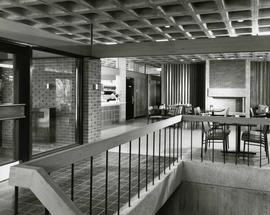
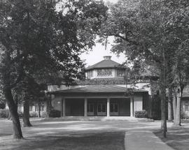
Interior of Peguis Pavilion in Kildonan Park
Photograph of the interior of the Peguis Pavilion in Kildonan Park. Featured is a small sitting area with tables and a small canteen window. Photograph by Henry Kalen.
Metropolitan Corporation of Greater Winnipeg (Man.). Information Officer

Main Street, south of Seven Oaks, 48 hours after rain
Date of photograph is July 8, 1932.
Photograph shows pavilion at Kildonan Park, a structure that was later demolished. Date of photograph is approximate, ca. 1920.
![Kildonan Park [Aerial view]](/uploads/r/city-of-winnipeg-archives-amp-records-control-branch/f/5/8/f589f26a584950aadbe5b101158e69cde3cad16f0f0cf05dcbb2a97e34661f16/C0013_0000_0000_P0018_0037_001_142.jpg)
Inscription (on recto): WG M35: 2-18, 5 Mar. '45, Kildonan Park, Wpg [Winnipeg], appr. scale 1/12000.
![Vicinity of Elmwood Park [Aerial view]](/uploads/r/city-of-winnipeg-archives-amp-records-control-branch/c/6/d/c6dc0bd0b8c2199f232fe8c7f5245d25e681a6a759be00e013a35a7a1ecada23/C0013_0000_0000_P0018_0042_001_142.jpg)
Vicinity of Elmwood Park [Aerial view]
Inscription (on recto): WG M35: 3-16, 5 Mar '45, vicinity Elmwood Park Wpg, appr scale 1/12000.

Woman standing beside large tree in Kildonan Park
Photograph shows unidentified woman posing next to large tree, taken during the fall season. One of three photos mounted on page with caption "Scenes - Kildonan Park." Date of photograph is probable, [1923?].
221, 231 and 233 Scotia Street
Part of City of Winnipeg (1874-1971)
A photograph taken during the 1950 flood, showing 221 Scotia Street and 231 Scotia Street and 233 Scotia Street. Item is 7 of 7 photographs on page 47 of scrapbook.
Harold K. White Studio

Aerial of 1974 Flood – Red River between North and West Kildonan
Aerial photograph of the Red River during the 1974 Flood. The photograph faces west from North Kildonan, where the Chief Peguis Trail now stands, across the river towards Kildonan Park and West Kildonan on the left, the North End Water Treatment Plant in the middle, and Old Kildonan on the right. The photographs were taken by the Department of Environmental Planning.
Winnipeg (Man.). Department of Environmental Planning
Winnipeg (Man.). Parks and Recreation Department
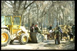
1997 flood - Kildonan Park - military personnel making sandbags
Part of Winnipeg Flood Record and Archives Committee collection
A photograph of military personnel making sandbags in Kildonan Park during the 1997 flood.
Winnipeg (Man.). Community Services Department
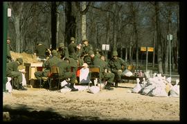
1997 flood - Kildonan Park - military personnel making sandbags
Part of Winnipeg Flood Record and Archives Committee collection
A photograph of military personnel making sandbags in Kildonan Park during the 1997 flood.
Winnipeg (Man.). Community Services Department
From a collection of records about the history of parks and recreational activities in Winnipeg with photos of Kildonan Park.
Winnipeg (Man.). Board of Parks and Recreation
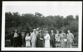
A group photo in the gardens in Kildonan Park
A group photo of people in formal dress in the gardens at Kildonan Park.
Winnipeg (Man.). Board of Parks and Recreation
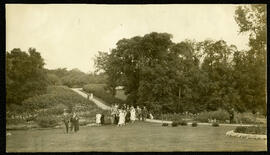
A group of people walking into the gardens at Kildonan Park
A photo of a group of people in formal wear walking into the gardens at Kildonan Park.
Winnipeg (Man.). Board of Parks and Recreation