
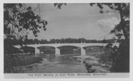
The Foot Bridge in City Park, Winnipeg, Manitoba
- i01802
- Item
- 1940
Photograph shows the foot bridge across the Assiniboine River in City Park. Date of photograph is approximate, ca. 1940.
3968 results with digital objects Show results with digital objects
The Foot Bridge in City Park, Winnipeg, Manitoba
Photograph shows the foot bridge across the Assiniboine River in City Park. Date of photograph is approximate, ca. 1940.
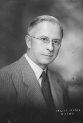
Photograph shows G. F. Bentley, former City Clerk, 1935-1945. Date of photograph is approximate, ca. 1945.
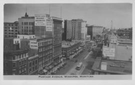
Portage Avenue, Winnipeg, Manitoba
Photograph shows view of Paris and Avenue buildings and Bank of Nova Scotia building. Date of photograph is approximate, ca. 1940.
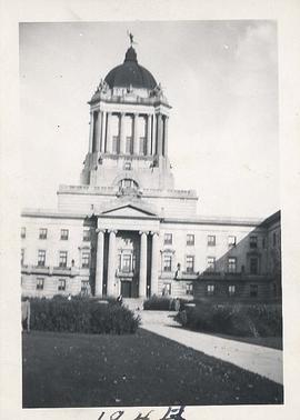
Students from Normal School at Legislative Building
Photograph shows Manitoba Legislative Building with Golden Boy clearly visible. Students from Normal School can be seen posing in front.
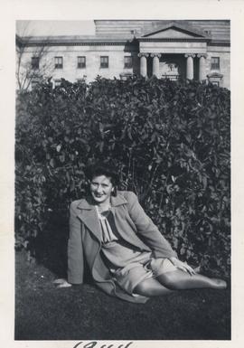
Student from Normal School sitting in front of Legislative Building
Photograph shows student, unidentified woman, from Normal School sitting on lawn in front of Manitoba Legislative Building.

Photograph shows Eaton's storefront decorated with flags as part of the Victory in Europe Day (VE Day) celebrations that marked the end of World War II in Europe.

Council Meeting, November 2, 1977
Photograph shows first session of Council after it was reduced from 50 Councillors to 29 Councillors, taken from seating gallery looking down into Council Chamber. - Stamp (on verso): Photograph by Hugh Allan, 116 Hazeldell Ave, Winnipeg, Man., R2F 0P5.
Allan, Hugh
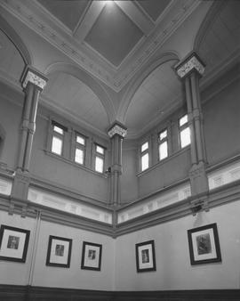
Interior view of City Hall showing ceilings
Photograph shows interior of Winnipeg's second City Hall (1886-1962) with ceilings in view. - Stamp (on verso): Henry Kalen, Photographer, 236 Ness Avenue, Winnipeg 12, Canada, Ph. VE 2-0294.
Kalen, Henry
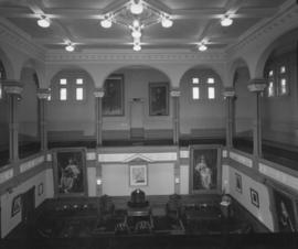
Interior of the Council Chamber at City Hall, view from upper level
Photograph shows Council Chamber, interior view of Winnipeg's second City Hall (1886-1962), taken from upper level. - Stamp (on verso): Henry Kalen, Photographer, 236 Ness Avenue, Winnipeg 12, Canada, Ph. VE 2-0294.
Kalen, Henry
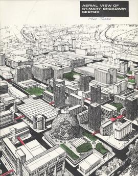
Downtown Winnipeg - Aerial view of St. Mary-Broadway Sector (Map Three)
Items shows drawing in printed format that record plans for downtown area.
Metropolitan Corporation of Greater Winnipeg (Man.). Planning Division
![C.P.R. Yards looking West [Aerial view]](/uploads/r/city-of-winnipeg-archives-amp-records-control-branch/1/d/2/1d24b0471a50903dd76276838a7e169e4890a17020a9cfe6a0d34e153ebb9ec9/C0013_0000_0000_P0018_0027_001_142.jpg)
C.P.R. Yards looking West [Aerial view]
Inscription (on recto): WG A114 30-2-42 CPR [Canadian Pacific Railway] RR [Railroad] Yards looking West.
![East Kildonan [Aerial view]](/uploads/r/city-of-winnipeg-archives-amp-records-control-branch/8/6/0/860fdea3b1f6bcb68bd68a791365ae9deb8f9cd14834a8814d48663ae6ce80b6/C0013_0000_0000_P0018_0031_001_142.jpg)
Inscription (on recto): WG A155, East Kildonan - 1944.
![Logan Avenue and Salter Street [Aerial view]](/uploads/r/city-of-winnipeg-archives-amp-records-control-branch/9/8/0/980f8ba4214d821c9b49366ae35d9ea9ed5b7f44366c5cd894e04befdd6c7a22/C0013_0000_0000_P0018_0033_001_142.jpg)
Logan Avenue and Salter Street [Aerial view]
Inscription (on recto): A161 3-9-43 Logan Ave and Salter St Wp [Winnipeg?] about 4000' 5".
![Kildonan Park [Aerial view]](/uploads/r/city-of-winnipeg-archives-amp-records-control-branch/f/5/8/f589f26a584950aadbe5b101158e69cde3cad16f0f0cf05dcbb2a97e34661f16/C0013_0000_0000_P0018_0037_001_142.jpg)
Inscription (on recto): WG M35: 2-18, 5 Mar. '45, Kildonan Park, Wpg [Winnipeg], appr. scale 1/12000.
![Sargent Park vicinity [Aerial view]](/uploads/r/city-of-winnipeg-archives-amp-records-control-branch/6/d/b/6dbefceeef372f0514de159e1569f5aba581dc63a4d454200688557662b9ce22/C0013_0000_0000_P0018_0038_001_142.jpg)
Sargent Park vicinity [Aerial view]
Inscription (on recto): WG M35: 5-9, 5 Mar. '45, Sgt Park Vicinity, appr. scale 1/12000.
![Vicinity of Elmwood Park [Aerial view]](/uploads/r/city-of-winnipeg-archives-amp-records-control-branch/c/6/d/c6dc0bd0b8c2199f232fe8c7f5245d25e681a6a759be00e013a35a7a1ecada23/C0013_0000_0000_P0018_0042_001_142.jpg)
Vicinity of Elmwood Park [Aerial view]
Inscription (on recto): WG M35: 3-16, 5 Mar '45, vicinity Elmwood Park Wpg, appr scale 1/12000.
![Assiniboine to Airport, St. James [Aerial view]](/uploads/r/city-of-winnipeg-archives-amp-records-control-branch/c/9/8/c986dd715644d9b7d48854b59c8285d029a7db80cb4798af462d336b696964c9/C0013_0000_0000_P0018_0043_001_142.jpg)
Assiniboine to Airport, St. James [Aerial view]
Inscription (on recto): WG M35: 7-16, 5 Mar '45, Assiniboine to Airport, St. James, app scale 1/12000.

Festoon Lighting Ceremony, Courtyard, City Hall, November 17, 1978, Mayor Steen
Allan, Hugh
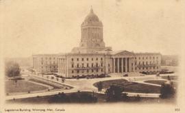
Legislative Building, Winnipeg, Man., Canada
Item consists of a postcard in printed format that shows the Manitoba Legislative Building. Date of postcard is unknown.
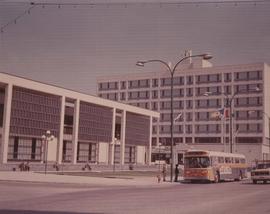
A photograph of the Civic Centre Complex, Winnipeg's third city hall (1964-present). Council Building, Administration Building, and public transit bus in view. Taken from William Avenue and Main Street, looking northwest. Date of photograph is uncertain, [197-?]. The photographer is likely Henry Kalen.
Kalen, Henry