

Winnipeg, Main Street looking south, Spring of 1874
- i00036
- Item
- 1874
Part of City of Winnipeg (1874-1971)
Photograph taken from top of Courthouse.
519 results with digital objects Show results with digital objects
Winnipeg, Main Street looking south, Spring of 1874
Part of City of Winnipeg (1874-1971)
Photograph taken from top of Courthouse.
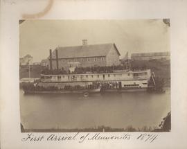
First arrival of Mennonites, 1874
Part of City of Winnipeg (1874-1971)

Pontoon Bridge, Fort Garry and Warehouse from south side Assiniboine River
Part of City of Winnipeg (1874-1971)

Point Douglas from Courthouse, 1874
Part of City of Winnipeg (1874-1971)

Main Street looking north from Portage Avenue
Part of City of Winnipeg (1874-1971)
Bentley Building, Courthouse and Artesian well shown in photograph.
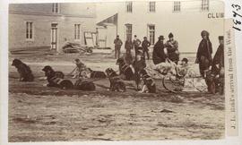
J. L. Reid's arrival from the west
Part of City of Winnipeg (1874-1971)
Dog sled shown in photograph.

Part of City of Winnipeg (1874-1971)

Main Street north of Portage Avenue
Photograph of a muddy Main Street in 1872, facing north from Portage Avenue and lined with shops on both sides, including a provisions store on the very right.
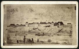
Photograph taken of a sketch by an unknown artist of Upper Fort Garry. In addition to the fort, soldiers in formation are featured, as are canoes and Indigenous peoples across the Assinibone River. The photograph's reverse side credits it to J. Penrose Photo Studio.

Part of City of Winnipeg (1874-1971)
Ox drawn cart shown in photograph.

Main Street looking northeast to Grace Methodist Church
Photograph of a muddy Main Street in 1871, facing northeast from around St. Mary Avenue. Featured on the photograph's right-hand side is Grace Methodist Church, located at Main Street and Water Avenue (now William Stephenson Way), which was opened on September 17 of that year.

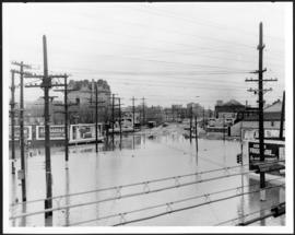
Foot of Robert Street (Galt Ave)
Part of City of Winnipeg (1874-1971)
A photograph of the Eaton's printing plant and warehouse on Robert Street (Galt Avenue) during the 1950 flood. The building is surrounded by a sandbag dike and water.
Harold K. White Studio
Main Street looking south from Main Street Bridge
Part of City of Winnipeg (1874-1971)
A photograph of flooded Main Street, looking south from the Main Street Bridge, during the 1950 flood in Winnipeg.
Harold K. White Studio

Part of City of Winnipeg (1874-1971)
A photograph of the intersection of Broadway and Osborne Street during the 1950 flood in Winnipeg. The photo is taken from Osborne Street, looking north; the stone cross of All Saints' Church can be seen near the left side of the image.
Harold K. White Studio

Pumping water on Robert Street
Part of City of Winnipeg (1874-1971)
A photograph of a pipe pouring water onto tracks on Robert Street (Galt Avenue) during the 1950 flood. A pile of wood is along one side of the street. The Ogilvie Flour Mill can be seen in the background.
Harold K. White Studio

Building Water Street causeway about 2nd day
Part of City of Winnipeg (1874-1971)
A photograph of the building of the Water Street causeway during the 1950 flood in Winnipeg. St. Boniface Cathedral can be seen in the background.
Harold K. White Studio
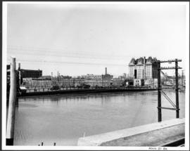
Part of City of Winnipeg (1874-1971)
A photograph of the Main Street Bridge during the 1950 flood in Winnipeg. The Hotel Fort Garry can be seen in the background.
Harold K. White Studio

Part of City of Winnipeg (1874-1971)
A photograph of floodwater and sandbag dikes outside 368 and 372 Main Street during the 1950 flood in Winnipeg.
Harold K. White Studio
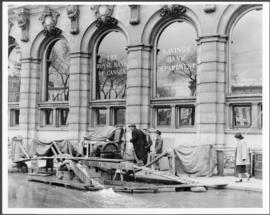
Part of City of Winnipeg (1874-1971)
A photograph of floodwater and a pump outside the Royal Bank on Main Street during the 1950 flood in Winnipeg.
Harold K. White Studio