
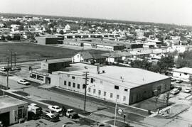
7-eleven and Shell station on Rothesay between Edison and Kingsford
- i04666
- Item
- [197-?]
7-Eleven store and Shell Service Station on Rothesay Street between Edison and Kingsford Avenues.
957 results with digital objects Show results with digital objects
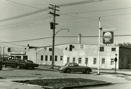
7-eleven and Shell station on Rothesay between Edison and Kingsford
7-Eleven store and Shell Service Station on Rothesay Street between Edison and Kingsford Avenues.
7-eleven and Shell station on Rothesay between Edison and Kingsford
7-Eleven store and sign of Shell Service Station on Rothesay Street between Edison and Kingsford Avenues.
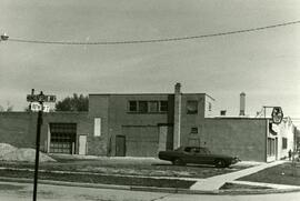
7-Eleven at the corner of Rothesay and Kingsford
Photograph of a 7-Eleven store at the corner of Rothesay Street and Kingsford Avenue.
![A corner of our flower bed [146 Spence Street]](/uploads/r/city-of-winnipeg-archives-amp-records-control-branch/8/3/0/8303d86cfc1c3c535a8e5720f2911f54450e682e3755309c35bb6135bc015541/C0013_0000_0000_P0022_0095_055_142.jpg)
A corner of our flower bed [146 Spence Street]
Date of photograph is approximate, ca. 1914.

A few of Winnipeg's handsome buildings
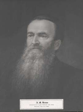
Caption: A. M. Brown. Appointed City Clerk, February 2nd, 1874. Resigned, June 11th, 1883.

A military funeral, Broadway and Spence Streets, Winnipeg - 1914
Photograph taken at time of World War 1.

Aerial of 1974 Flood – Bergen Cutoff Bridge
Aerial photograph of the Bergen Cutoff Bridge during the 1974 Flood. The photograph faces northwest from Kildonan Drive in North Kildonan across the Red River towards Kildonan Park and Old Kildonan. The photographs were taken by the Department of Environmental Planning.
Winnipeg (Man.). Department of Environmental Planning

Aerial of 1974 Flood – Fraser’s Grove Park
Aerial photograph of the Red River during the 1974 Flood. The photograph faces southwest from Fraser’s Grove Park and Kildonan Drive in East Kildonan towards Scotia Street in the Seven Oaks area of West Kildonan. The photographs were taken by the Department of Environmental Planning.
Winnipeg (Man.). Department of Environmental Planning

Aerial of 1974 Flood – Pritchard Avenue Boat Dock and Redwood Bridge
Aerial photograph of the Red River during the 1974 Flood. The photograph faces northwest towards the North End, with the Pritchard Avenue Boat Dock in the bottom left and the Redwood Bridge in the top right. The photographs were taken by the Department of Environmental Planning.
Winnipeg (Man.). Department of Environmental Planning

Aerial of 1974 Flood – Red River between East and West Kildonan
Aerial photograph of the Red River during the 1974 Flood. The photograph faces northwest from around Helmsdale Avenue and Kildonan Drive in East Kildonan towards Scotia Street in the Seven Oaks area of West Kildonan across the river. The photographs were taken by the Department of Environmental Planning.
Winnipeg (Man.). Department of Environmental Planning

Aerial of 1974 Flood – Red River between North and West Kildonan
Aerial photograph of the Red River during the 1974 Flood. The photograph faces west from North Kildonan, where the Chief Peguis Trail now stands, across the river towards Kildonan Park and West Kildonan on the left, the North End Water Treatment Plant in the middle, and Old Kildonan on the right. The photographs were taken by the Department of Environmental Planning.
Winnipeg (Man.). Department of Environmental Planning

Aerial photograph area west of Red River, south of Winnipeg City Limits, 1943
Photograph shows an aerial view of the area west of Red River, south of Winnipeg City Limits. Photograph is dated December 2, 1943.
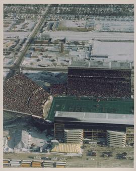
Aerial photograph of the Winnipeg Stadium during the 1991 Grey Cup Game
A photograph of the Winnipeg Stadium during the 1991 Grey Cup Game. That year the Toronto Argonauts were victorious, defeating the Calgary Stampeders 36 to 21.

Photograph shows an aerial view of the Red River north from the southern boundaries of North Kildonan and West St. Paul, north of Winnipeg. Photograph is dated December 2, 1943.

Aerial photograph south of Winnipeg, east of Red River, 1943
Photograph shows an aerial view of south of Winnipeg, east of Red River. Photograph dated December 2, 1943.

Aerial photograph south side of Assiniboine River, west from Assiniboine Park, 1943
Photograph shows an aerial view of the south side of the Assiniboine River, west from Assiniboine Park. Photograph is dated December 2, 1943.
Aerial view looking south from over Wesley Park at rear of United College
Date of photograph is approximate, ca. 1937.

An aerial view of East Kildonan between the roughly between the Red River and Watt Street, including Henderson Highway.

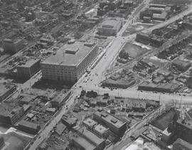
Aerial view of intersection at Portage Avenue and Main Street
Photograph shows aerial view of intersection at Portage Avenue and Main Street (after barriers closing intersection to pedestrian concourse). Also shows Bank of Nova Scotia (Trizec Building) under construction. Photograph likely taken from the top of the Richardson Building.
Allan, Hugh