
Showing 34 results
archival descriptions
Foot of Water Street, C.N.R. Bridge - the Flood

Foot of Colony Street

Floods - St. Boniface and Norwood - April 1916

Flooded residential street, 1916 Flood, Norwood
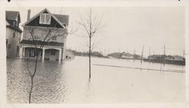
Flood water over front porch of home, 1916 Flood, Norwood
Dyking built up around Shaarey Zedek Synagogue, 1950 Flood

Colony Street and Whitehall Avenue

Assiniboine Bridge

Aerial of 1974 Flood – Red River between North and West Kildonan

Aerial of 1974 Flood – Red River between East and West Kildonan

Aerial of 1974 Flood – Pritchard Avenue Boat Dock and Redwood Bridge

Aerial of 1974 Flood – Fraser’s Grove Park

Aerial of 1974 Flood – Bergen Cutoff Bridge

1950 Flood - Flood Evacuees at the St. Boniface train station
Results 21 to 34 of 34
- « Previous
- 1
- 2