
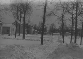
Wildwood Park - Three weeks before flood, 1950
- i02074
- Item
- 1950
355 results with digital objects Show results with digital objects
Wildwood Park - Three weeks before flood, 1950
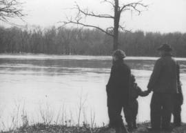
Photograph shows four people on riverbank looking out at high waters and flooded area in Wildwood Park during 1950 Flood.

Sandbags on the dyke (Wildwood Park - flood, 1950)
![Sandbags - E sec [section] (Wildwood Park - flood, 1950)](/uploads/r/city-of-winnipeg-archives-amp-records-control-branch/c/4/a/c4a7e5ee657f2cf565da1e983d41beae65af0b67f4b9fb5fa71c540b99003de4/C0013_0000_0000_P0022_0094_001_142.jpg)
Sandbags - E sec [section] (Wildwood Park - flood, 1950)

Colony Street and Whitehall Avenue
Photograph is one of five photos mounted on page with caption "Assiniboine River flooded, Spring 1916."

Photograph is one of five photos mounted on page with caption "Assiniboine River flooded, Spring 1916."

Photograph is one of five photos mounted on page with caption "Assiniboine River flooded, Spring 1916."

Photograph is one of five photos mounted on page with caption "Assiniboine River flooded, Spring 1916."

Foot of Water Street, C.N.R. Bridge - the Flood
Photograph is one of five photos mounted on page with caption "Assiniboine River flooded, Spring 1916."

Aerial of 1974 Flood – Red River between East and West Kildonan
Aerial photograph of the Red River during the 1974 Flood. The photograph faces northwest from around Helmsdale Avenue and Kildonan Drive in East Kildonan towards Scotia Street in the Seven Oaks area of West Kildonan across the river. The photographs were taken by the Department of Environmental Planning.
Winnipeg (Man.). Department of Environmental Planning

Aerial of 1974 Flood – Red River between North and West Kildonan
Aerial photograph of the Red River during the 1974 Flood. The photograph faces west from North Kildonan, where the Chief Peguis Trail now stands, across the river towards Kildonan Park and West Kildonan on the left, the North End Water Treatment Plant in the middle, and Old Kildonan on the right. The photographs were taken by the Department of Environmental Planning.
Winnipeg (Man.). Department of Environmental Planning

Aerial of 1974 Flood – Bergen Cutoff Bridge
Aerial photograph of the Bergen Cutoff Bridge during the 1974 Flood. The photograph faces northwest from Kildonan Drive in North Kildonan across the Red River towards Kildonan Park and Old Kildonan. The photographs were taken by the Department of Environmental Planning.
Winnipeg (Man.). Department of Environmental Planning

Aerial of 1974 Flood – Pritchard Avenue Boat Dock and Redwood Bridge
Aerial photograph of the Red River during the 1974 Flood. The photograph faces northwest towards the North End, with the Pritchard Avenue Boat Dock in the bottom left and the Redwood Bridge in the top right. The photographs were taken by the Department of Environmental Planning.
Winnipeg (Man.). Department of Environmental Planning

Aerial of 1974 Flood – Fraser’s Grove Park
Aerial photograph of the Red River during the 1974 Flood. The photograph faces southwest from Fraser’s Grove Park and Kildonan Drive in East Kildonan towards Scotia Street in the Seven Oaks area of West Kildonan. The photographs were taken by the Department of Environmental Planning.
Winnipeg (Man.). Department of Environmental Planning
Winnipeg Flood Record and Archives Committee collection
Collection consists of 9 series. Series 209 consists mostly of reports and published accounts. Series 210 documents the work of the Emergency Preparedness and Coordination Committee (EEPC) under the finding aid heading “Emergency Program”. Collection includes textual and electronic records, correspondence, fact sheets, property listings, press releases, bulletins, public inquiry forms, newspapers, maps, pictures, and video tapes.
Part of Winnipeg Flood Record and Archives Committee collection
Community Services - "Manitoba Flood '97" photos on CDs
Part of Winnipeg Flood Record and Archives Committee collection
Subseries consists of digital photographs of various homes and street scenes taken during the 1997 flood in Winnipeg, as well as relief efforts. The photographs were originally housed on three CDs.
Winnipeg (Man.). Community Services Department

Part of Winnipeg Flood Record and Archives Committee collection
A photograph of 201 Kingston Row during the 1997 flood.
Winnipeg (Man.). Community Services Department
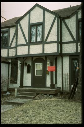
1997 flood - Kingston Row - house
Part of Winnipeg Flood Record and Archives Committee collection
A photograph of a house on Kingston Row during the 1997 flood.
Winnipeg (Man.). Community Services Department

1997 flood - Kingston Row - signage
Part of Winnipeg Flood Record and Archives Committee collection
A photograph of signage on Kingston Row during the 1997 flood.
Winnipeg (Man.). Community Services Department