Showing 75 results

archival descriptions
City of Winnipeg Archives Photograph collection Commercial buildings English
Print preview Hierarchy View:

73 results with digital objects Show results with digital objects

Polo Park Shopping Centre panorama

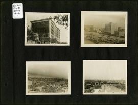
View of Polo Park Shopping Centre, 1485 Portage Avenue, 41 acres. West side of shopping centre, north side of Portage Avenue between Empress Street and St. James Street. Left to Right: Winnipeg Stadium, Winnipeg Arena, Loblaws, Simpson Sears Marina, Simpson Sears Garden Shop, Simpson Sears Department Store, Simpson Sears Service Station. Consists of 4 separate photographs pasted together on cardboard to create a panorama. The cardboard is a scrap made from an old sign of the Metropolitan Corporation of Greater Winnipeg (visible on the reverse). The cardboard is numbered “11”, presumably as part of a compilation with other shopping centre panoramas.

Metropolitan Corporation of Greater Winnipeg (Man.). Planning Division

Polo Park Shopping Centre panorama

View of Polo Park Shopping Centre, 1485 Portage Avenue, 41 acres. East side of shopping centre. From left to right: the Pancake House, Simpsons-Sears, Perth's Dry Cleaners, Genser's Furniture, Daytons, Jack and Jill, Reward, Gordi's Restaurant, Ricki’s, addition to shopping centre under construction, Dominion Store, CJAY-TV Station (CKY-TV), Winnipeg Arena. Consists of 4 separate photographs pasted together on cardboard to create a panorama. The cardboard is a scrap made from an old sign of the Metropolitan Corporation of Greater Winnipeg (visible on the reverse). The cardboard is numbered “12”, presumably as part of a compilation with other shopping centre panoramas.

Metropolitan Corporation of Greater Winnipeg (Man.). Planning Division

Polo Park Shopping Centre panorama

View of Polo Park Shopping Centre, 1485 Portage Avenue, 41 acres. South side of shopping centre. Left to right: Winnipeg Motor Products, Motor Club, Simpson Sears Service Station, Simpson Sears Department Store. Consists of 3 separate photographs pasted together on cardboard to create a panorama. The cardboard is a scrap made from an old sign of the Metropolitan Corporation of Greater Winnipeg (visible on the reverse). The cardboard is numbered “13”, presumably as part of a compilation with other shopping centre panoramas.

Metropolitan Corporation of Greater Winnipeg (Man.). Planning Division

Arthur and Fred Landen photograph album

Photograph album created by brothers Arthur and Fred Landen of Hull, England. Consists of circa 150 photographs of Arthur Landen’s time as Honourable Lieutenant and Quartermaster in the 1st Battalion of the Northumberland Fusiliers while stationed in Spain, Gibraltar, Egypt, and elsewhere in Africa between 1887 and 1907, as well as circa 40 photographs of Fred Landen’s stay in Winnipeg between 1903 and 1906 and his home in Hull, England. Winnipeg photographs feature homes, commercial buildings, and modes of transporation. The pages are loose and many of the photographs are faded.

Landen, Frederick Cluett

Dakota Village Shopping Centre panorama

View of Dakota Village Shopping Centre, 1077-1095 St. Mary's Road, 3.5 acres. From left to right: unknown stores, Ladies and Children's Wear, Lance Pharmacy, [Dakota?] Bowling, Shoe Fair, Bank of Nova Scotia, Safeway, apartment block, Bank of Montreal. Consists of 3 separate photographs pasted together on cardboard to create a panorama. The cardboard is a scrap made from an old sign of the Metropolitan Corporation of Greater Winnipeg (visible on the reverse). The cardboard is numbered “6”, presumably as part of a compilation with other shopping centre panoramas.

Metropolitan Corporation of Greater Winnipeg (Man.). Planning Division

Rossmere Shopping Centre panorama

View of Rossmere Shopping Centre, 1070 Henderson Highway, southwest corner Rowandale, 4.25 acres. From left to right: a garage or car wash, Red River Co-Op Store, Rossmere Lanes Bowling Alley, Library, Dry Cleaners, Co-operators Credit Union Society Limited, Rowandale Baptist Church, Rowandale Apartments, Red River Co-Op Gas Station. Consists of 3 separate photographs pasted together on cardboard to create a panorama. The cardboard is a scrap made from an old sign of the Metropolitan Corporation of Greater Winnipeg (visible on the reverse). The cardboard is numbered “2”, presumably as part of a compilation with other shopping centre panoramas.

Metropolitan Corporation of Greater Winnipeg (Man.). Planning Division

Southgate Shopping Centre panorama

View of Southgate Village Shopping Centre, 1305-1341 Pembina Highway at the southwest corner of McGillivray Boulevard, 3.3 acres. From left to right: Pembina Curling Rink, Imperial Cleaners, Safeway, The Place, Young Togs, Reid Marshall Pharmacy, The Village Gift Shop, The French Salon, Marshall Wells, The Toronto Dominion Bank, Safeway gas bar. Consists of 3 separate photographs pasted together on cardboard to create a panorama. The cardboard is a scrap made from an old sign of the Metropolitan Corporation of Greater Winnipeg (visible on the reverse). The cardboard is numbered “7”, presumably as part of a compilation with other shopping centre panoramas.

Metropolitan Corporation of Greater Winnipeg (Man.). Planning Division

Northdale Shopping Centre panorama

View of Northdale Shopping Centre, 963 Henderson Highway, 7.65 acres. From left to right: Loblaws Groceteria, Zeller's County Fair, various shops, the Royal Bank, the Canadian Imperial Bank of Commerce, A & P Food Store, Lord Wolseley School. Consists of 3 separate photographs pasted together on cardboard to create a panorama. The cardboard is a scrap made from an old sign of the Metropolitan Corporation of Greater Winnipeg (visible on the reverse). The cardboard is numbered “1”, presumably as part of a compilation with other shopping centre panoramas.

Metropolitan Corporation of Greater Winnipeg (Man.). Planning Division

Crossroads Shopping Centre panorama

View of Crossroads Shopping Centre, 1580 Regent Avenue W., 18 acres. From left to right: Woolco Department Store, Various shops, Safeway, Pacific 66 Gas Bar. Consists of 3 separate photographs pasted together on cardboard to create a panorama. The cardboard is a scrap made from an old sign of the Metropolitan Corporation of Greater Winnipeg (visible on the reverse). The cardboard is numbered “3”, presumably as part of a compilation with other shopping centre panoramas.

Metropolitan Corporation of Greater Winnipeg (Man.). Planning Division

Grant Plaza Shopping Centre panorama

View of Grant Park Plaza Shopping Centre, 1200-1216 Grant Avenue, 13.2 acres. From left to right: Clarks Discount Store, Dominion Store, Liquor Commission, Clarks Auto Centre. Consists of 3 separate photographs pasted together on cardboard to create a panorama. The cardboard is a scrap made from an old sign of the Metropolitan Corporation of Greater Winnipeg (visible on the reverse). The cardboard is numbered “8”, presumably as part of a compilation with other shopping centre panoramas.

Metropolitan Corporation of Greater Winnipeg (Man.). Planning Division

Southdale Shopping Centre panorama

View of Southdale Shopping Centre, 35 Lakewood Boulevard, 12.8 acres. From left to right: Dominion Store, Canadian Imperial Bank of Commerce, Mall Entrance, Quintons, Ebbeling Pharmacy, Kmart Department Store. Consists of 3 separate photographs pasted together on cardboard to create a panorama. The cardboard is a scrap made from an old sign of the Metropolitan Corporation of Greater Winnipeg (visible on the reverse). The cardboard is numbered “5”, presumably as part of a compilation with other shopping centre panoramas.

Metropolitan Corporation of Greater Winnipeg (Man.). Planning Division

Photograph album of Winnipeg during WW1: Page 6

Item consists of a scrapbook page showing soldiers marching in military parade on street in front of the Elliott and Hazel Grocers, 975 Main Street and the H. Lindster's Bakery, 971 Main Street (Item 25), soldiers lined up in military parade (Item 26),
soldiers marching in military parade (Item 27), soldiers marching in military parade (Item 28), [ca. 1913].

Photograph album of Winnipeg during WW1: Page 3

Item consists of a scrapbook page showing the Young Men's Christian Association (YMCA) Building at 301 Vaughan Street (Item 13); view of Portage Avenue with Eaton's and Boyd buildings in foreground and Hotel Fort Garry in the background (Item 14); view of Ashford's Bakery at Portage Avenue and Furby Street, facing south towards Broadway (Item 15); Vaughan Street facing north towards St. Paul's College on Ellice Avenue (Item 16). Dates of photographs are approximate, [ca. 1913].

Results 21 to 40 of 75