

Eaton's promotional stereogram no. 32 - city delivery
- i04502
- Item
- [ca. 1920]
Part of Morris Block collection
Block, Morris
351 results with digital objects Show results with digital objects
Eaton's promotional stereogram no. 32 - city delivery
Part of Morris Block collection
Block, Morris
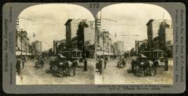
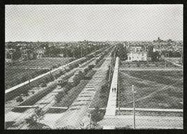
Main Street, looking north from Portage
Part of Morris Block collection
A promotional stereogram showing traffic and streetcars on Main Street, looking north from Portage Avenue, made by the Keystone View Company. The reverse side of the image contains information about Winnipeg.
Block, Morris
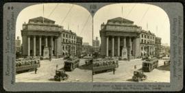
Bank of Montreal building, Portage and Main
Part of Morris Block collection
A promotional stereogram showing traffic and streetcars in front of the Bank of Montreal building at Portage Avenue and Main Street, made by the Keystone View Company. The reverse side of the image contains information about Winnipeg.
Block, Morris
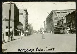
Portage looking east from around Carlton
Part of Morris Block collection
Photograph of a woman crossing Portage Avenue, looking east from around Carlton Street. The Eaton’s building can be seen on the right.
Block, Morris
Part of Morris Block collection
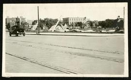
Photograph of a pile of collapsed advertisement signs on an otherwise empty lot.
Block, Morris

Part of Morris Block collection
Photograph of a family standing on a platform or rail cart on rail tracks.
Block, Morris
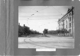
Broadway looking west from Fort Garry Court
Part of Morris Block collection
Photograph taken from Fort Garry Court, located at Broadway and Main Street, looking west down Broadway. St. Mary’s Academy, the Parliament Building (Legislature), and Law Courts are labeled off in the distance.
Block, Morris

For Your Guidance While in Winnipeg promotional map
Part of Morris Block collection
A promotional map created by the Publicity Bureau of Winnipeg and Manitoba titled "For Your Guidance While in Winnipeg". Map was originally folded as a pamphlet, the front page of which features a graphic of two people driving down Highway 14 (now Highway 75) to Winnipeg. The map is not scale and features cartoon depictions of tourist destinations and landmarks around Winnipeg and St. Boniface. The maps shows major streets, railroads, and street railway lines. The map side was originally framed and cut to fit. At a result a small part of the front page is cut off, including a stamp reading "St. Raphael's Ukrainian Immigrants' Welfare Association of Can[ada]".
Block, Morris
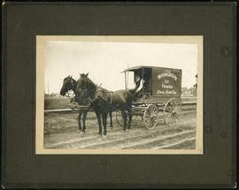
Western Cake and Pie Co carriage
Part of Morris Block collection
Photograph mounted on cardboard of the horse-drawn delivery wagon of the Western Cake and Pie Comapany, owned by Crane and David, who owned a bakery at 765 Dufferin Avenue.
Block, Morris
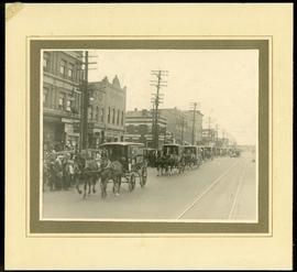
Canada Bread delivery wagons at Main and Selkirk
Part of Morris Block collection
Photograph mounted on cardboard of a cavalcade of Canada Bread horse-drawn delivery wagons riding south down Main Street, at the corner of Selkirk Avenue.
Block, Morris

Banfiend’s Furniture carts in front of Empire Hotel
Part of Morris Block collection
Photograph mounted on cardboard of a cavalcade of horse-drawn wagons in front of the Empire Hotel on Main Street and York Avenue, advertising deals on 3-room furniture suites at Banfield’s Furniture, 492 Main Street.
Block, Morris
Crescentwood Park and Broadway
A photo album page with a view of Crescentwood Park on the first side and a view of Broadway from Main Street on the second side.
A photograph of streetcar on Broadway, looking west from Main Street. The Manitoba Club building can be seen on the left. Photographed by Steele and Company.
Photographs of the opening of the Nairn Overpass and green space near it.

Preliminary Report on Transportation - Metropolitan Plan for Greater Winnipeg
Part of City Clerk's Library collection
Item consists of 1 report (41 pages), jointly prepared by the Metropolitan Planning Committee and Winnipeg Town Planning Commission. The report focuses on transportation in the Greater Winnipeg Area. Part of the Metropolitan Plan for Greater Winnipeg - number 3 of master plan reports.
Manitoba. Metropolitan Planning Commission of Greater Winnipeg
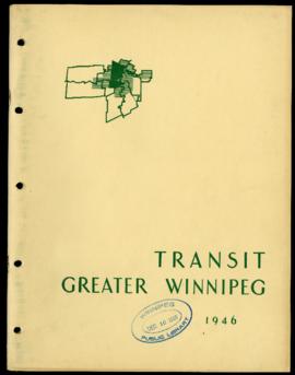
Preliminary Report on Transit - Metropolitan Plan for Greater Winnipeg
Part of City Clerk's Library collection
Item consists of 1 report (43 pages), jointly prepared by the Metropolitan Planning Committee and Winnipeg Town Planning Commission. The report focuses on transit in the Greater Winnipeg Area. Part of the Metropolitan Plan for Greater Winnipeg - number 4 of master plan reports.
Manitoba. Metropolitan Planning Commission of Greater Winnipeg

Waghorn's Guide map and street index
Part of City Clerk's Library collection
Waghorn's Guide - a small promotional pamphlet published by J.R. Waghorn in 1895. The pamphlet contains a street map of Winnipeg, a street index, and advertisements for various Winnipeg businesses including the Clarendon Hotel, the Redwood Brewery, and the Massey-Harris Company. The map shows the old City of Winnipeg from the Red River on the east to Waverly, Aubrey, and McPhillips Streets on the west, and from Athole Avenue (now Luxton Avenue) in the north to Parker Avenue in the south. Southern Elmwood, Old St. Boniface, and Norwood are also shown on the east side of the river. Railway lines are in black and electric street railway lines are in red.
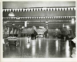
A car show likely held at the Civic Auditorium on Vaughan Street. Several cars are on display from brands such as Hudson and Austin.
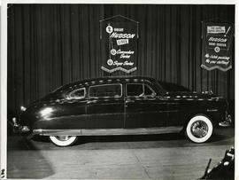
A Hudson brand car on display at a car show likely held in the Civic Auditorium on Vaughan Street. Banners advertiseing the Commodre and Super Series cars hang above.
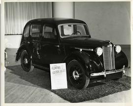
Austin Eight Saloon at car show
An Austin Eight Saloon model car at a car show likely held in the Civic Auditorium on Vaughan Street.