
Winnipeg Convention Centre grand opening
- i04653
- Item
- 14 Jan. 1975
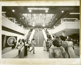
Guests gather in front of the grand staircase for the grand opening of the Winnipeg Convention Centre on January 14, 1975.
957 results with digital objects Show results with digital objects
Winnipeg Convention Centre grand opening
Guests gather in front of the grand staircase for the grand opening of the Winnipeg Convention Centre on January 14, 1975.
New bridge on Portage Ave crossing Sturgeon Creek
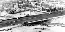
Aerial view of the bridge on Portage Avenue over Sturgeon Creek after it was opened to traffic on December 8, 1981.
Texaco station at 312 Hargrave
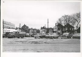
Cars parked at Texaco service station at 312 Hargrave Avenue. Signs nearby advertize West End Furniture, Sweet Caporal Cigarettes, and Perth’s.
T. Eaton parking lot on west side of Donald
Parking lot of T. Eaton Company, located on the west side of Donald between St. Mary and York Avenues, looking east.
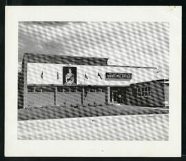
East Kildonan Municipal Offices.
East Kildonan Municipal Offices at 755 Henderson Highway.

An aerial view of East Kildonan between the roughly between the Red River and Watt Street, including Henderson Highway.
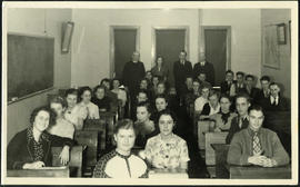
Jon Bjarnason Academy – grade 12 class and faculty
Group photograph of the 1937-38 grade 12 class at Jon Bjarnason Academy (652 Home Street), seated in their desks with faculty standing behind them.
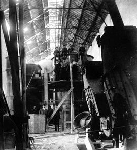
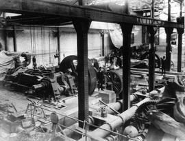
James Avenue Pumping Station – interior
Interior shot of the James Avenue Pumping Station on James Avenue and Amy Street, still under construction.
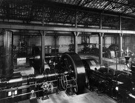
James Avenue Pumping Station – interior
Interior shot of the James Avenue Pumping Station on James Avenue and Amy Street.
James Avenue Pumping Station – interior
Interior shot of the James Avenue Pumping Station on James Avenue and Amy Street, still under construction.

Winnipeg Tourist Cabins and Camp Park on Pembina Highway
Postcard featuring “Winnipeg Tourist Cabins and Camp Park”, located on Pembina Highway (then Highway Number 14) around Chevrier Boulevard.

Winnipeg’s Best Tourist Cabin Camp on Pembina Highway
Postcard featuring “Winnipeg’s Best Tourist Cabin Camp”, located on Pembina Highway (then Highway Number 14) around Chevrier Boulevard.
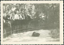
Original beaver enclosure at Assiniboine Park
Audience admiring a beaver in Assiniboine Park’s first beaver enclosure.

Aerial of 1974 Flood – Fraser’s Grove Park
Aerial photograph of the Red River during the 1974 Flood. The photograph faces southwest from Fraser’s Grove Park and Kildonan Drive in East Kildonan towards Scotia Street in the Seven Oaks area of West Kildonan. The photographs were taken by the Department of Environmental Planning.
Winnipeg (Man.). Department of Environmental Planning

Aerial of 1974 Flood – Pritchard Avenue Boat Dock and Redwood Bridge
Aerial photograph of the Red River during the 1974 Flood. The photograph faces northwest towards the North End, with the Pritchard Avenue Boat Dock in the bottom left and the Redwood Bridge in the top right. The photographs were taken by the Department of Environmental Planning.
Winnipeg (Man.). Department of Environmental Planning

Aerial of 1974 Flood – Bergen Cutoff Bridge
Aerial photograph of the Bergen Cutoff Bridge during the 1974 Flood. The photograph faces northwest from Kildonan Drive in North Kildonan across the Red River towards Kildonan Park and Old Kildonan. The photographs were taken by the Department of Environmental Planning.
Winnipeg (Man.). Department of Environmental Planning

Aerial of 1974 Flood – Red River between North and West Kildonan
Aerial photograph of the Red River during the 1974 Flood. The photograph faces west from North Kildonan, where the Chief Peguis Trail now stands, across the river towards Kildonan Park and West Kildonan on the left, the North End Water Treatment Plant in the middle, and Old Kildonan on the right. The photographs were taken by the Department of Environmental Planning.
Winnipeg (Man.). Department of Environmental Planning

Aerial of 1974 Flood – Red River between East and West Kildonan
Aerial photograph of the Red River during the 1974 Flood. The photograph faces northwest from around Helmsdale Avenue and Kildonan Drive in East Kildonan towards Scotia Street in the Seven Oaks area of West Kildonan across the river. The photographs were taken by the Department of Environmental Planning.
Winnipeg (Man.). Department of Environmental Planning
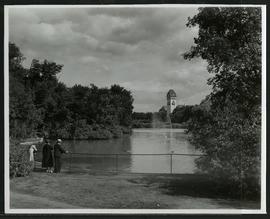
Duck pond and pavilion at Assiniboine Park
A family enjoying the duck pond and the view of the pavilion at Assiniboine Park.

Thoroughfares: Academy Road at Wellington Crescent
View of cars and cyclists heading down Academy Road towards Wellington Crescent and the Maryland Bridge. A small portion of Misericordia Hospital can be seen across the bridge.