Print preview Close

Showing 576 results

archival descriptions
Winnipeg (Man.). Downtown
Print preview Hierarchy View:

521 results with digital objects Show results with digital objects

38 and 40 Hargrave Street

A photograph taken during the 1950 flood, showing 38 Hargrave Street and 40 Hargrave Street. Item is 1 of 8 photographs on page 83 of scrapbook.

Harold K. White Studio

28 and 30 Hargrave Street

A photograph taken during the 1950 flood, showing 28 Hargrave Street and 30 Hargrave Street. Item is 3 of 8 photographs on page 83 of scrapbook.

Harold K. White Studio

24 and 26 Hargrave Street

A photograph taken during the 1950 flood, showing 24 Hargrave Street and 26 Hargrave Street. Item is 4 of 8 photographs on page 83 of scrapbook.

Harold K. White Studio

35 Hargrave Street

A photograph taken during the 1950 flood, showing 35 Hargrave Street. Item is 2 of 7 photographs on page 84 of scrapbook.

Harold K. White Studio

27 and 33 Hargrave Street

A photograph taken during the 1950 flood, showing 27 Hargrave Street and 33 Hargrave Street. Item is 3 of 7 photographs on page 84 of scrapbook.

Harold K. White Studio

Osborne and Broadway

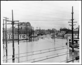
A photograph of the intersection of Broadway and Osborne Street during the 1950 flood in Winnipeg. The photo is taken from Osborne Street, looking north; the stone cross of All Saints' Church can be seen near the left side of the image.

Harold K. White Studio

Scrapbook [1950 flood photographs]

Subseries consists of a scrapbook assembled by the City Engineering Department to serve as photographic evidence of the 1950 flood. It contains black and white photographs that mostly document flooding in residential areas near the Red River (Fort Rouge, Riverview, North End, Point Douglas, Crescentwood, Armstrong's Point and others). Scrapbook appears to be organized geographically by area and street. In addition to documenting flooding, the photographs provide a detailed record of residential neighbourhoods, houses, streets, and businesses like corner grocery stores and laundries. All photographs were taken by Harold K. White Studio.

Winnipeg (Man.). City Engineer

46 Notre Dame East

A photograph taken during the 1950 flood, showing 46 Notre Dame East. Item is 2 of 6 photographs on page 55 of scrapbook.

Harold K. White Studio

103 Notre Dame East

A photograph taken during the 1950 flood, showing 103 Notre Dame East. Item is 4 of 6 photographs on page 55 of scrapbook.

Harold K. White Studio

William Smaill Photo Album – Page 20

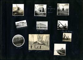
Captions read: Mile 85 - Old Fort Garry and hotel - Fort Garry apartments - Hudson's Bay stores, Winnipeg - Bay City dredge - Whitemouth, April 1914 - W.G. Chas, J.H. Fuertes [?], A. C.H. Blanchard [?] - Mile 57.

Smaill, William

Portage and Main, looking west down Portage Avenue

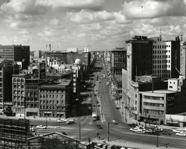
Photograph of Portage Avenue looking west from the intersection at Main Street. Various shops and business are featured in buildings at Portage and Main that no longer exist, including the towering McArthur/Child's Building on the right. Photograph by Henry Kalen.

Metropolitan Corporation of Greater Winnipeg (Man.). Information Officer

Results 21 to 40 of 576