
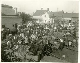
The North End market behind Dufferin Avenue and Derby Street
- i04002
- Item
- [ca. 1914]
Carts of goods and shoppers in a bustling market around Dufferin Avenue and Derby Street in the North End.
42 results with digital objects Show results with digital objects
The North End market behind Dufferin Avenue and Derby Street
Carts of goods and shoppers in a bustling market around Dufferin Avenue and Derby Street in the North End.
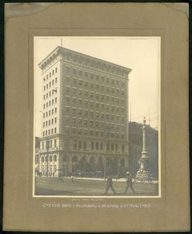
Union Bank Building – Cotter Brothers Plumbing and Heating
Part of Morris Block collection
Photograph mounted on cardboard of the Union Bank Building at Main St. and William Avenue and the Volunteer monument. The caption below the photograph implies that the photograph was taken by or for the Cotter Brothers – Plumbing and Heating Contractors.
Block, Morris
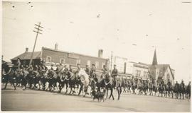
Photograph shows Lord Strathcona Horse, just before departure overseas during World War 1, at Selkirk and Main, looking at the east side of Main Street..
Plans for Nurses Home Childrens’ Hospital, 131 Aberdeen Avenue
Part of City of Winnipeg (1874-1971)
Winnipeg (Man.). City Engineer

Photograph album of Winnipeg during WW1: Page 5
Item consists of a scrapbook page showing soldiers lined up in military parade in front of the Industrial Bureau Exposition Building (Item 21), soldiers lined up in military parade (Item 22),
soldiers on horse in military parade in front of the Industrial Bureau Exposition Building (Item 23), crowd forming on street in front of the Israelite Jewish Daily newspaper building (975 Main Street) and the H. Lindster's Bakery (971 Main Street). Soldiers and Police in foreground (Item 24), [ca. 1913].

Photograph album of Winnipeg during WW1: Page 6
Item consists of a scrapbook page showing soldiers marching in military parade on street in front of the Elliott and Hazel Grocers, 975 Main Street and the H. Lindster's Bakery, 971 Main Street (Item 25), soldiers lined up in military parade (Item 26),
soldiers marching in military parade (Item 27), soldiers marching in military parade (Item 28), [ca. 1913].
Plans for New Laundry Building, Childrens' Hospital
Part of City of Winnipeg (1874-1971)
Winnipeg (Man.). City Engineer

Crane and David (Western Cake and Pie Co) storefront
Part of Morris Block collection
Group photograph mounted on cardboard of the staff of Crane and David, Bakers and Confectioners (also knows as the Western Cake and Pie Company) in front of their store at 765 Dufferin Avenue.
Block, Morris
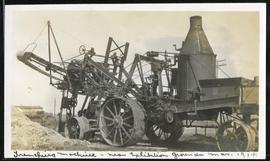
Trenching machine near Exhibition Grounds
Part of Morris Block collection
Block, Morris
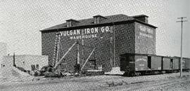
Photograph of the Vulcan Iron Works on page 152 of the Illustrated Souvenir of Winnipeg, published by W.M. Maretl and Sons, Half-Tone Engravers, in Winnipeg ca. 1903.
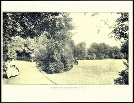
A quiet corner in St. John's Park.
Plans for Children's Hospital, Aberdeen Avenue
Part of City of Winnipeg (1874-1971)
Winnipeg (Man.). City Engineer
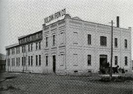
Photograph of the Vulcan Iron Works on page 153 of the Illustrated Souvenir of Winnipeg, published by W.M. Maretl and Sons, Half-Tone Engravers, in Winnipeg ca. 1903.
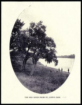
The Red River from St. John's Park.

Arthur and Fred Landen photograph album – page 31
Page 31 of a photograph album created by brothers Arthur and Fred Landen of Hull, England. Page consists of 6 photographs taken by Fred Landen depicting, clockwise from top-left: shacks in residential area, likely the North End; men lighting a mosquito fire on the banks of the Red River; Fred Landen sitting on the bank of the Red River; a large house with brick veneer; a large house with wood veneer; and a horse-drawn sleigh advertising “A. Hendry. Grocer.” in front of a large house.
Landen, Frederick Cluett

Waghorn's Guide map and street index
Part of City Clerk's Library collection
Waghorn's Guide - a small promotional pamphlet published by J.R. Waghorn in 1895. The pamphlet contains a street map of Winnipeg, a street index, and advertisements for various Winnipeg businesses including the Clarendon Hotel, the Redwood Brewery, and the Massey-Harris Company. The map shows the old City of Winnipeg from the Red River on the east to Waverly, Aubrey, and McPhillips Streets on the west, and from Athole Avenue (now Luxton Avenue) in the north to Parker Avenue in the south. Southern Elmwood, Old St. Boniface, and Norwood are also shown on the east side of the river. Railway lines are in black and electric street railway lines are in red.
Part of City of Winnipeg (1874-1971)
A photograph taken during the 1950 flood, showing 78 Barber Street and 90 Barber Street and 92 Barber Street. Item is 4 of 5 photographs on page 58 of scrapbook.
Harold K. White Studio
Part of City of Winnipeg (1874-1971)
A photograph taken during the 1950 flood, showing 96 Barber Street. Item is 5 of 5 photographs on page 58 of scrapbook.
Harold K. White Studio
Part of City of Winnipeg (1874-1971)
A photograph taken during the 1950 flood, showing 44 Grove Street and 46 Grove Street. Item is 2 of 8 photographs on page 59 of scrapbook.
Harold K. White Studio
Part of City of Winnipeg (1874-1971)
A photograph taken during the 1950 flood, showing 46 Grove Street and 48 Grove Street. Item is 3 of 8 photographs on page 59 of scrapbook.
Harold K. White Studio