
Plans for Children's Hospital, Aberdeen Avenue
- i03531
- Item
- 1910
Part of City of Winnipeg (1874-1971)
Winnipeg (Man.). City Engineer
42 results with digital objects Show results with digital objects
Plans for Children's Hospital, Aberdeen Avenue
Part of City of Winnipeg (1874-1971)
Winnipeg (Man.). City Engineer
Part of City of Winnipeg (1874-1971)
Winnipeg (Man.). City Engineer

Photograph album of Winnipeg during WW1: Page 6
Item consists of a scrapbook page showing soldiers marching in military parade on street in front of the Elliott and Hazel Grocers, 975 Main Street and the H. Lindster's Bakery, 971 Main Street (Item 25), soldiers lined up in military parade (Item 26),
soldiers marching in military parade (Item 27), soldiers marching in military parade (Item 28), [ca. 1913].

Photograph album of Winnipeg during WW1: Page 5
Item consists of a scrapbook page showing soldiers lined up in military parade in front of the Industrial Bureau Exposition Building (Item 21), soldiers lined up in military parade (Item 22),
soldiers on horse in military parade in front of the Industrial Bureau Exposition Building (Item 23), crowd forming on street in front of the Israelite Jewish Daily newspaper building (975 Main Street) and the H. Lindster's Bakery (971 Main Street). Soldiers and Police in foreground (Item 24), [ca. 1913].

Northgate Shopping Centre panorama
View of Northgate Plaza Shopping Centre, 1375-1425 McPhillips Street, 15 acres. From left to right: Clarks Discount Store, Various Shops, Northgate Bowling Lanes, Loblaw's. Consists of 3 separate photographs pasted together on cardboard to create a panorama. The cardboard is a scrap made from an old sign of the Metropolitan Corporation of Greater Winnipeg (visible on the reverse). The cardboard is numbered “14”, presumably as part of a compilation with other shopping centre panoramas.
Metropolitan Corporation of Greater Winnipeg (Man.). Planning Division

Part of City of Winnipeg (1874-1971)
Photograph shows the North End Farmer's Market (west side Main Street, north of Stella Avenue, looking west to King Street). Included in photograph: front entrance to market, automobiles parked on street, and North End Horse Exchange (523 King Street). Photograph likely taken from 919-921 Main Street by city employee.

Part of City of Winnipeg (1874-1971)
Photograph shows the North End Farmer's Market, looking east across Main Street (northwest Main Street and Stella Avenue). Included in photograph: stalls filled with vegetables and people walking through the market, Aime Bicycle Shop, 909 Main Street, two-storey brick building (899-905 Main Street), and Norquay School.
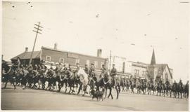
Photograph shows Lord Strathcona Horse, just before departure overseas during World War 1, at Selkirk and Main, looking at the east side of Main Street..
![Logan Avenue and Main Street [Aerial view]](/uploads/r/city-of-winnipeg-archives-amp-records-control-branch/d/9/2/d92728eee72f0ac3b14bbb8ea8f04c5d3ece08f19538ee5d078eb79492de602b/C0013_0000_0000_P0018_0034_001_142.jpg)
Logan Avenue and Main Street [Aerial view]
Inscription (on recto): A160 3-9-43 Logan Ave and Main St Wpg [Winnipeg] about 4000' 5".

Part of City of Winnipeg (1874-1971)
A photograph of children on Higgins Avenue during the 1950 flood. Piles of earth and sandbags line the street.
Harold K. White Studio

Part of City of Winnipeg (1874-1971)
A photograph of a flooded underpass on Higgins Avenue during the 1950 flood.
Harold K. White Studio

Part of City of Winnipeg (1874-1971)
A photograph of Higgins Avenue during the 1950 flood. A bridge over the swollen Red River can also be seen.
Harold K. White Studio

Gladstone Street from Sutherland Avenue
Part of City of Winnipeg (1874-1971)
A photograph of flooding on Gladstone Street during the 1950 flood in Winnipeg. The photograph was taken from Sutherland Avenue.
Harold K. White Studio

Part of City of Winnipeg (1874-1971)
A photograph of flooding in a residential area of Winnipeg during the 1950 flood. The photograph was taken at the intersection of Disraeli and Euclid.
Harold K. White Studio
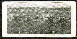
Eaton's promotional stereogram no. 12 - Winnipeg stock yards
Part of Morris Block collection
Block, Morris

Part of City of Winnipeg (1874-1971)
A photograph of flooding on Disraeli St during the 1950 flood. The photograph shows a child standing on a pile of lumber beside the flooded street.
Harold K. White Studio

Crane and David, Bakers and Confectioners
Staff standing in front of Crane and David Bakers and Confectioners at 765 Dufferin Avenue and a horse-drawn delivery cart.

Crane and David (Western Cake and Pie Co) storefront
Part of Morris Block collection
Group photograph mounted on cardboard of the staff of Crane and David, Bakers and Confectioners (also knows as the Western Cake and Pie Company) in front of their store at 765 Dufferin Avenue.
Block, Morris
![C.P.R. Yards looking West [Aerial view]](/uploads/r/city-of-winnipeg-archives-amp-records-control-branch/1/d/2/1d24b0471a50903dd76276838a7e169e4890a17020a9cfe6a0d34e153ebb9ec9/C0013_0000_0000_P0018_0027_001_142.jpg)
C.P.R. Yards looking West [Aerial view]
Inscription (on recto): WG A114 30-2-42 CPR [Canadian Pacific Railway] RR [Railroad] Yards looking West.

Central Business District: Aerial view - Central Winnipeg
Date of photograph is approximate, ca. 1947.