
- i01446
- Item
- [between 1914 and 1918]
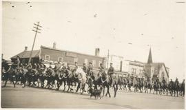
Photograph shows Lord Strathcona Horse, just before departure overseas during World War 1, at Selkirk and Main, looking at the east side of Main Street..
37 results with digital objects Show results with digital objects
Photograph shows Lord Strathcona Horse, just before departure overseas during World War 1, at Selkirk and Main, looking at the east side of Main Street..
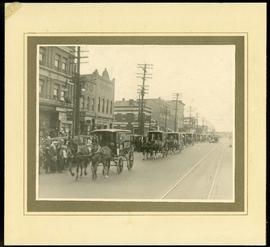
Canada Bread delivery wagons at Main and Selkirk
Part of Morris Block collection
Photograph mounted on cardboard of a cavalcade of Canada Bread horse-drawn delivery wagons riding south down Main Street, at the corner of Selkirk Avenue.
Block, Morris
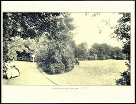
A quiet corner in St. John's Park.
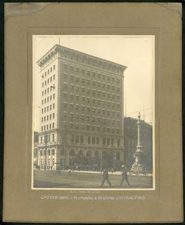
Union Bank Building – Cotter Brothers Plumbing and Heating
Part of Morris Block collection
Photograph mounted on cardboard of the Union Bank Building at Main St. and William Avenue and the Volunteer monument. The caption below the photograph implies that the photograph was taken by or for the Cotter Brothers – Plumbing and Heating Contractors.
Block, Morris
Plans for Children's Hospital, Aberdeen Avenue
Part of City of Winnipeg (1874-1971)
Winnipeg (Man.). City Engineer
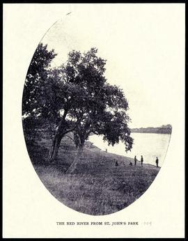
The Red River from St. John's Park.

Crane and David, Bakers and Confectioners
Staff standing in front of Crane and David Bakers and Confectioners at 765 Dufferin Avenue and a horse-drawn delivery cart.

Crane and David (Western Cake and Pie Co) storefront
Part of Morris Block collection
Group photograph mounted on cardboard of the staff of Crane and David, Bakers and Confectioners (also knows as the Western Cake and Pie Company) in front of their store at 765 Dufferin Avenue.
Block, Morris
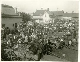
The North End market behind Dufferin Avenue and Derby Street
Carts of goods and shoppers in a bustling market around Dufferin Avenue and Derby Street in the North End.

Waghorn's Guide map and street index
Part of City Clerk's Library collection
Waghorn's Guide - a small promotional pamphlet published by J.R. Waghorn in 1895. The pamphlet contains a street map of Winnipeg, a street index, and advertisements for various Winnipeg businesses including the Clarendon Hotel, the Redwood Brewery, and the Massey-Harris Company. The map shows the old City of Winnipeg from the Red River on the east to Waverly, Aubrey, and McPhillips Streets on the west, and from Athole Avenue (now Luxton Avenue) in the north to Parker Avenue in the south. Southern Elmwood, Old St. Boniface, and Norwood are also shown on the east side of the river. Railway lines are in black and electric street railway lines are in red.
Part of City of Winnipeg (1874-1971)
A photograph taken during the 1950 flood, showing 78 Barber Street and 90 Barber Street and 92 Barber Street. Item is 4 of 5 photographs on page 58 of scrapbook.
Harold K. White Studio
Part of City of Winnipeg (1874-1971)
A photograph taken during the 1950 flood, showing 96 Barber Street. Item is 5 of 5 photographs on page 58 of scrapbook.
Harold K. White Studio
Part of City of Winnipeg (1874-1971)
A photograph taken during the 1950 flood, showing 44 Grove Street and 46 Grove Street. Item is 2 of 8 photographs on page 59 of scrapbook.
Harold K. White Studio
Part of City of Winnipeg (1874-1971)
A photograph taken during the 1950 flood, showing 46 Grove Street and 48 Grove Street. Item is 3 of 8 photographs on page 59 of scrapbook.
Harold K. White Studio
Part of City of Winnipeg (1874-1971)
A photograph taken during the 1950 flood, showing 90 Grove Street and 92 Grove Street. Item is 8 of 8 photographs on page 59 of scrapbook.
Harold K. White Studio
Part of City of Winnipeg (1874-1971)
A photograph taken during the 1950 flood, showing 83 Grove Street. Item is 3 of 6 photographs on page 60 of scrapbook.
Harold K. White Studio
Part of City of Winnipeg (1874-1971)
A photograph taken during the 1950 flood, showing 146 Gomez Street and 150 Gomez Street. Item is 4 of 6 photographs on page 60 of scrapbook.
Harold K. White Studio
111, 113, 115 and 117 Disraeli Street
Part of City of Winnipeg (1874-1971)
A photograph taken during the 1950 flood, showing 111 Disraeli Street and 113 Disraeli Street and 115 Disraeli Street and 117 Disraeli Street. Item is 6 of 6 photographs on page 62 of scrapbook.
Harold K. White Studio
Part of City of Winnipeg (1874-1971)
A photograph taken during the 1950 flood, showing 84 Disraeli Street and 86 Disraeli Street. Item is 3 of 5 photographs on page 63 of scrapbook.
Harold K. White Studio
102, 104 and 106 Disraeli Street
Part of City of Winnipeg (1874-1971)
A photograph taken during the 1950 flood, showing 102 Disraeli Street and 104 Disraeli Street and 106 Disraeli Street. Item is 5 of 5 photographs on page 63 of scrapbook.
Harold K. White Studio