
- i00486
- Item
- 1950
Part of City of Winnipeg (1874-1971)
A photograph taken during the 1950 flood, showing 99 Matheson Avenue and 103 Matheson Avenue. Item is 5 of 6 photographs on page 42 of scrapbook.
Harold K. White Studio
42 results with digital objects Show results with digital objects
Part of City of Winnipeg (1874-1971)
A photograph taken during the 1950 flood, showing 99 Matheson Avenue and 103 Matheson Avenue. Item is 5 of 6 photographs on page 42 of scrapbook.
Harold K. White Studio
Part of City of Winnipeg (1874-1971)
A photograph taken during the 1950 flood, showing 84 Scotia Avenue and 86 Scotia Avenue and 90 Scotia Avenue. Item is 4 of 8 photographs on page 44 of scrapbook.
Harold K. White Studio
156, 158, 160 and 162 Scotia Avenue
Part of City of Winnipeg (1874-1971)
A photograph taken during the 1950 flood, showing 156 Scotia Avenue and 158 Scotia Avenue and 160 Scotia Avenue and 162 Scotia Avenue. Item is 7 of 8 photographs on page 44 of scrapbook.
Harold K. White Studio
Part of City of Winnipeg (1874-1971)
A photograph taken during the 1950 flood, showing 111 Scotia Street and 117 Scotia Street. Item is 4 of 8 photographs on page 46 of scrapbook.
Harold K. White Studio
Part of City of Winnipeg (1874-1971)
A photograph taken during the 1950 flood, showing 185 Scotia Street and 195 Scotia Street. Item is 2 of 7 photographs on page 47 of scrapbook.
Harold K. White Studio
221, 231 and 233 Scotia Street
Part of City of Winnipeg (1874-1971)
A photograph taken during the 1950 flood, showing 221 Scotia Street and 231 Scotia Street and 233 Scotia Street. Item is 7 of 7 photographs on page 47 of scrapbook.
Harold K. White Studio
Part of City of Winnipeg (1874-1971)
A photograph taken during the 1950 flood, showing 9 Bannerman Avenue and 11 Bannerman Avenue and 18 Bannerman Avenue. Item is 3 of 7 photographs on page 48 of scrapbook.
Harold K. White Studio
17, 19 and 21 Bannerman Avenue
Part of City of Winnipeg (1874-1971)
A photograph taken during the 1950 flood, showing 17 Bannerman Avenue and 19 Bannerman Avenue and 21 Bannerman Avenue. Item is 4 of 7 photographs on page 48 of scrapbook.
Harold K. White Studio
Part of City of Winnipeg (1874-1971)
A photograph taken during the 1950 flood, showing 27 Bannerman Avenue and 31 Bannerman Avenue. Item is 6 of 7 photographs on page 48 of scrapbook.
Harold K. White Studio
Part of City of Winnipeg (1874-1971)
A photograph taken during the 1950 flood, showing 35 Luxton Avenue and 37 Luxton Avenue. Item is 1 of 8 photographs on page 49 of scrapbook.
Harold K. White Studio
18, 20 and 22 Lansdowne Avenue
Part of City of Winnipeg (1874-1971)
A photograph taken during the 1950 flood, showing 18 Lansdowne Avenue and 20 Lansdowne Avenue and 22 Lansdowne Avenue. Item is 1 of 8 photographs on page 51 of scrapbook.
Harold K. White Studio
32, 34 and 36 Lansdowne Avenue
Part of City of Winnipeg (1874-1971)
A photograph taken during the 1950 flood, showing 32 Lansdowne Avenue and 34 Lansdowne Avenue and 36 Lansdowne Avenue. Item is 3 of 8 photographs on page 51 of scrapbook.
Harold K. White Studio
48, 50 and 52 Lansdowne Avenue
Part of City of Winnipeg (1874-1971)
A photograph taken during the 1950 flood, showing 48 Lansdowne Avenue and 50 Lansdowne Avenue and 52 Lansdowne Avenue. Item is 5 of 8 photographs on page 51 of scrapbook.
Harold K. White Studio
41, 45 and 47 Lansdowne Avenue
Part of City of Winnipeg (1874-1971)
A photograph taken during the 1950 flood, showing 41 Lansdowne Avenue and 45 Lansdowne Avenue and 47 Lansdowne Avenue. Item is 4 of 8 photographs on page 52 of scrapbook.
Harold K. White Studio
Part of City of Winnipeg (1874-1971)
A photograph taken during the 1950 flood, showing 29 Polson Avenue and 31 Polson Avenue. Item is 2 of 8 photographs on page 53 of scrapbook.
Harold K. White Studio
Part of City of Winnipeg (1874-1971)
A photograph taken during the 1950 flood, showing 33 Polson Avenue and 35 Polson Avenue and 39 Polson Avenue. Item is 3 of 8 photographs on page 53 of scrapbook.
Harold K. White Studio
Part of City of Winnipeg (1874-1971)
A photograph taken during the 1950 flood, showing 67 Barber Street and 69 Barber Street. Item is 6 of 8 photographs on page 57 of scrapbook.
Harold K. White Studio
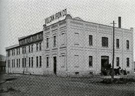
Photograph of the Vulcan Iron Works on page 153 of the Illustrated Souvenir of Winnipeg, published by W.M. Maretl and Sons, Half-Tone Engravers, in Winnipeg ca. 1903.

Aerial view of Point Douglas, St. Boniface, and Elmwood areas
Aerial photograph of Point Douglas, St. Boniface, and west Elmwood.

Waghorn's Guide map and street index
Part of City Clerk's Library collection
Waghorn's Guide - a small promotional pamphlet published by J.R. Waghorn in 1895. The pamphlet contains a street map of Winnipeg, a street index, and advertisements for various Winnipeg businesses including the Clarendon Hotel, the Redwood Brewery, and the Massey-Harris Company. The map shows the old City of Winnipeg from the Red River on the east to Waverly, Aubrey, and McPhillips Streets on the west, and from Athole Avenue (now Luxton Avenue) in the north to Parker Avenue in the south. Southern Elmwood, Old St. Boniface, and Norwood are also shown on the east side of the river. Railway lines are in black and electric street railway lines are in red.