A photograph taken during the 1950 flood, showing 85 Ashland Avenue and ? Ashland Avenue and ? Ashland Avenue and 95 Ashland Avenue and 99 Ashland Avenue and 103 Ashland Avenue and 107 Ashland Avenue. Item is 2 of 8 photographs on page 30 of scrapbook.
A photograph taken during the 1950 flood, showing 145 Ashland Avenue and 95 Ashland Avenue and 149 Ashland Avenue and 155 Ashland Avenue and 159 Ashland Avenue. Item is 5 of 8 photographs on page 30 of scrapbook.
A photograph taken during the 1950 flood, showing 253 Ashland Avenue and 255 Ashland Avenue and 261 Ashland Avenue and 265 Ashland Avenue. Item is 8 of 8 photographs on page 30 of scrapbook.
A photograph taken during the 1950 flood, showing 206 Ashland Avenue and 210 Ashland Avenue and 214 Ashland Avenue and 218 Ashland Avenue and 226 Ashland Avenue. Item is 3 of 5 photographs on page 31 scrapbook.
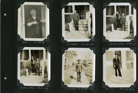
Page 5 of a photograph scrapbook made by Corporal John Wallace in April 1940. Photographs depict several acquaintenance of Wallace including two fellow soldiers, “Sonny” Robertson and Joseph “Fuss” McGrath, a Mrs. Penny, and a Frank Dowling and his family. See the general notes section for more details.
View of cars and cyclists heading down Academy Road towards Wellington Crescent and the Maryland Bridge. A small portion of Misericordia Hospital can be seen across the bridge.
Waghorn's Guide - a small promotional pamphlet published by J.R. Waghorn in 1895. The pamphlet contains a street map of Winnipeg, a street index, and advertisements for various Winnipeg businesses including the Clarendon Hotel, the Redwood Brewery, and the Massey-Harris Company. The map shows the old City of Winnipeg from the Red River on the east to Waverly, Aubrey, and McPhillips Streets on the west, and from Athole Avenue (now Luxton Avenue) in the north to Parker Avenue in the south. Southern Elmwood, Old St. Boniface, and Norwood are also shown on the east side of the river. Railway lines are in black and electric street railway lines are in red.