
![Central Winnipeg between Portage and Notre Dame Avenues [Aerial view]](/uploads/r/city-of-winnipeg-archives-amp-records-control-branch/e/3/f/e3f90f80ff2b9d7dc2938509d7f4a5b4dfdfef9308ecfc0cfa38d5f1e2aa0bb8/C0013_0000_0000_P0018_0026_001_142.jpg)
Central Winnipeg between Portage and Notre Dame Avenues [Aerial view]
- i01910
- Item
- 1942
Inscription (on recto): WG A158 8/6/1942 Central Wpg between Portage and Notre Dame Ave's.
341 results with digital objects Show results with digital objects
Central Winnipeg between Portage and Notre Dame Avenues [Aerial view]
Inscription (on recto): WG A158 8/6/1942 Central Wpg between Portage and Notre Dame Ave's.
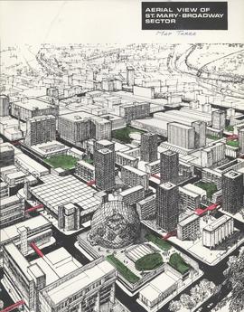
Downtown Winnipeg - Aerial view of St. Mary-Broadway Sector (Map Three)
Items shows drawing in printed format that record plans for downtown area.
Metropolitan Corporation of Greater Winnipeg (Man.). Planning Division
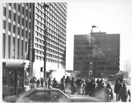
Caption (on file): "Shivering on the corner of Portage and Main on a cold, windy day waiting for traffic lights to change will now be just a memory with the opening of a climate controlled underground pedestrian concourse linking the four corners of Winnipeg's famous intersection."
Allan, Hugh
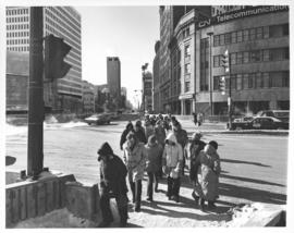

Aerial view of intersection at Portage Avenue and Main Street
Photograph shows aerial view of intersection at Portage Avenue and Main Street (after barriers closing intersection to pedestrian concourse). Also shows Bank of Nova Scotia (Trizec Building) under construction. Photograph likely taken from the top of the Richardson Building.
Allan, Hugh
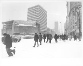
Caption (on file): "Residents of Winnipeg who for a hundred years have fought the wintry winds at the corner of Portage and Main will now cross in summertime comfort with the provision of an environmentally controlled pedestrian concourse beneath Canada's most famous corner."
Allan, Hugh


City Hall (exterior), No. C-508
Photograph of Civic Complex, showing Council Building and Administration Building, taken from corner of Main Street and William Avenue. Description (on verso): Third City Hall - Officially Opened October 5th, 1964. Photograph taken by Henry Kalen.
Kalen, Henry

C.P.R. Depot and Royal Alexandra Hotel, Winnipeg, Manitoba
Photograph shows Canadian Pacific Railway depot and Royal Alexandra Hotel on Higgins Avenue. Date of photograph is approximate, ca. 1940.
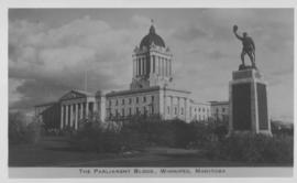
The Parliament Bldgs., Winnipeg, Manitoba
Photograph shows Parliament buildings (Manitoba Legislature) and Next of Kin Monument. Date of photograph is approximate, ca. 1940.

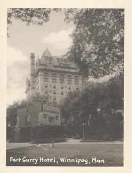
Fort Garry Hotel, Winnipeg, Manitoba
Photograph shows Fort Garry Hotel on Broadway Avenue. Date of photograph is approximate, ca. 1940.

Union Station, Winnipeg, Manitoba
Photograph shows Canadian National Railway Station (C.N.R. Station) on Main Street. Date of photograph is approximate, ca. 1940.
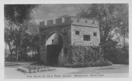
The Gate of Old Fort Garry, Winnipeg, Manitoba
Date of photograph is approximate, ca. 1940.

C.N.R. Station, Winnipeg, Man.
Photograph shows Canadian National Railway Station situated on Main Street.

City Hall, Winnipeg, Man. showing "Welcome Visitors" sign
Photograph shows Winnipeg's second city hall (1886-1962). Date of photograph is approximate, ca. 1940.
Fort Garry Hotel, Winnipeg, Man. showing Upper Fort Garry Gate in foreground
Date of photograph is approximate, ca. 1940.
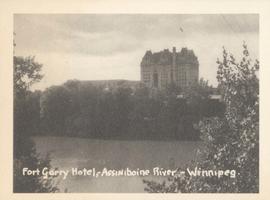
Fort Garry Hotel, Assiniboine River - Winnipeg
Photograph shows Fort Garry Hotel with view looking northwest over Assiniboine River. Date of photograph is approximate, ca. 1940.
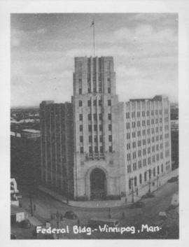
Photograph shows Federal building located on Main Street at Water Avenue.
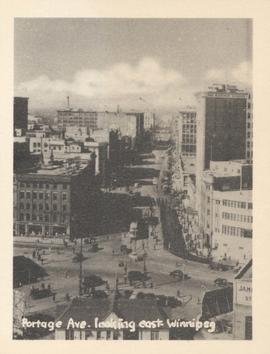
Portage Ave. looking east, Winnipeg
Photograph show Portage Avenue looking east from Main Street. Date of photograph is approximate, ca. 1940.
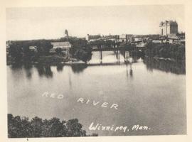
Junction of Red River and Assiniboine River
Photograph shows Fort Garry Hotel in background. Date of photograph is approximate, ca. 1940.