
Report - Retention of Police Training Records
- i04058
- Item
- 16 Feb. 1998
Part of City Archivist collection
Winnipeg (Man.). Records Committee
Report - Retention of Police Training Records
Part of City Archivist collection
Winnipeg (Man.). Records Committee
Part of City Archivist collection
Winnipeg (Man.). Records Committee
Part of City Archivist collection
Winnipeg (Man.). Records Committee

Report - Retention of Car Allowance Registries
Part of City Archivist collection
Winnipeg (Man.). Records Committee

Part of City Archivist collection
Winnipeg (Man.). Records Committee

Part of City Archivist collection
Winnipeg (Man.). Records Committee
Part of City Archivist collection
Winnipeg (Man.). Records Committee
Part of City Archivist collection
Winnipeg (Man.). Records Committee
Part of City Archivist collection
Winnipeg (Man.). Records Committee
Part of City Archivist collection
Winnipeg (Man.). Records Committee

Letter from Chairperson to Acting Director of the Water and Waste Department
Part of City Archivist collection
A letter from Marc Lemoine, Chairperson of the Records Committee, to Bill Borlase, Acting Director of the Water and Waste Department, regarding content for access guide.
Winnipeg (Man.). Records Committee

Part of City Archivist collection
Winnipeg (Man.). Records Committee

Letter from Chairperson to members of the Records Committee
Part of City Archivist collection
A letter from Marc Lemoine, Chairperson of the Records Committee, to members of the Records Committee, inviting them to first meeting of the Records Committee.
Winnipeg (Man.). Records Committee


For Your Guidance While in Winnipeg promotional map
Part of Morris Block collection
A promotional map created by the Publicity Bureau of Winnipeg and Manitoba titled "For Your Guidance While in Winnipeg". Map was originally folded as a pamphlet, the front page of which features a graphic of two people driving down Highway 14 (now Highway 75) to Winnipeg. The map is not scale and features cartoon depictions of tourist destinations and landmarks around Winnipeg and St. Boniface. The maps shows major streets, railroads, and street railway lines. The map side was originally framed and cut to fit. At a result a small part of the front page is cut off, including a stamp reading "St. Raphael's Ukrainian Immigrants' Welfare Association of Can[ada]".
Block, Morris

Waghorn's Guide map and street index
Part of City Clerk's Library collection
Waghorn's Guide - a small promotional pamphlet published by J.R. Waghorn in 1895. The pamphlet contains a street map of Winnipeg, a street index, and advertisements for various Winnipeg businesses including the Clarendon Hotel, the Redwood Brewery, and the Massey-Harris Company. The map shows the old City of Winnipeg from the Red River on the east to Waverly, Aubrey, and McPhillips Streets on the west, and from Athole Avenue (now Luxton Avenue) in the north to Parker Avenue in the south. Southern Elmwood, Old St. Boniface, and Norwood are also shown on the east side of the river. Railway lines are in black and electric street railway lines are in red.
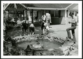
Aunt Sally's Farm at the Assiniboine Park Zoo
Photograph of visitors enjoying a fountain at Aunt Sally's Farm, in the Assiniboine Park Zoo. Photograph was taken by Gunter A. Schoch, Landscape Architect with the Metropolitan Corporation of Greater Winnipeg's Parks and Protection Division.
Metropolitan Corporation of Greater Winnipeg (Man.). Parks and Protection Division

An aerial view of East Kildonan between the roughly between the Red River and Watt Street, including Henderson Highway.