

- i00122
- Item
- May 15, 1950
Part of City of Winnipeg (1874-1971)
A photograph of Higgins Avenue during the 1950 flood. A bridge over the swollen Red River can also be seen.
Harold K. White Studio
Part of City of Winnipeg (1874-1971)
A photograph of Higgins Avenue during the 1950 flood. A bridge over the swollen Red River can also be seen.
Harold K. White Studio

Photograph shows old St. James Bridge approach, looking North up present Kintrye Street. Viscount Gort site centre right/Hydro sub-station - St. James Street and Portage Avenue far left. Date of photograph is uncertain [after 1932].
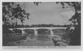
The Foot Bridge in City Park, Winnipeg, Manitoba
Photograph shows the foot bridge across the Assiniboine River in City Park. Date of photograph is approximate, ca. 1940.
![C.P.R. Yards looking West [Aerial view]](/uploads/r/city-of-winnipeg-archives-amp-records-control-branch/1/d/2/1d24b0471a50903dd76276838a7e169e4890a17020a9cfe6a0d34e153ebb9ec9/C0013_0000_0000_P0018_0027_001_142.jpg)
C.P.R. Yards looking West [Aerial view]
Inscription (on recto): WG A114 30-2-42 CPR [Canadian Pacific Railway] RR [Railroad] Yards looking West.

Thoroughfares: Academy Road at Wellington Crescent
View of cars and cyclists heading down Academy Road towards Wellington Crescent and the Maryland Bridge. A small portion of Misericordia Hospital can be seen across the bridge.

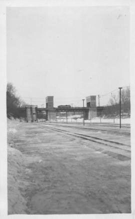
A photograph of the Portage Avenue underpass, which crosses Century Street on the north side of the St. James Bridge. The photographer is unknown.
Metropolitan Corporation of Greater Winnipeg (Man.). Information Officer
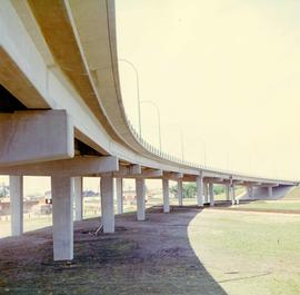
A colour photograph of the Nairn Overpass from below.
Metropolitan Corporation of Greater Winnipeg (Man.). Information Officer

Footbridge over Assiniboine River to City Park, Sunday afternoon
Date of photograph is approximate, ca. 1914.
Osborne bridge - toboggan slide, Winnipeg, Winter 1918

Photograph is one of five photos mounted on page with caption "Assiniboine River flooded, Spring 1916."

Part of City of Winnipeg (1874-1971)
A photograph of children on Higgins Avenue during the 1950 flood. Piles of earth and sandbags line the street.
Harold K. White Studio

Part of City of Winnipeg (1874-1971)
A photograph of a flooded underpass on Higgins Avenue during the 1950 flood.
Harold K. White Studio

Pontoon Bridge, Fort Garry and Warehouse from south side Assiniboine River
Part of City of Winnipeg (1874-1971)

No. 8 A portion of the Lyndale dike in Norwood with the Norwood Bridge in the background
Photograph shows scene from 1950 flood. Description (on verso): Note the roof of the Greater Winnipeg Sanitary District Marion Street pumping station on the right. Stamp (on verso): City of Winnipeg - Engineering Dept., Water Works Division, Ross and Tecumseh.
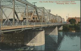
The Traffic Bridge over the Assiniboine River, Winnipeg
Date of postcard is uncertain, [before 1949].

Arlington Bridge from top of chimney
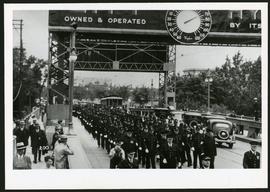
Police on Osborne Street Bridge during 1935 parade
A photograph of a parade on Osborne Street Bridge, taken 1935.

Aerial of 1974 Flood – Bergen Cutoff Bridge
Aerial photograph of the Bergen Cutoff Bridge during the 1974 Flood. The photograph faces northwest from Kildonan Drive in North Kildonan across the Red River towards Kildonan Park and Old Kildonan. The photographs were taken by the Department of Environmental Planning.
Winnipeg (Man.). Department of Environmental Planning
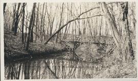
Photograph shows footbridge in wooded area, taken during the fall season. One of three photos mounted on page with caption "Scenes - Kildonan Park." Date of photograph is probable, [1923?].

Foot of Water Street, C.N.R. Bridge - the Flood
Photograph is one of five photos mounted on page with caption "Assiniboine River flooded, Spring 1916."