
- i01740
- Pièce
- 1940
Fait partie de City of Winnipeg Archives Photograph collection
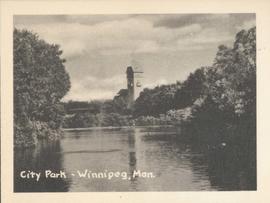
Photograph shows Assiniboine Park with pavilion and river in view. Date of photograph is approximate, ca. 1940.
Fait partie de City of Winnipeg Archives Photograph collection
Photograph shows Assiniboine Park with pavilion and river in view. Date of photograph is approximate, ca. 1940.
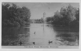
The Duck Pond, Winnipeg, Manitoba
Fait partie de City of Winnipeg Archives Photograph collection
Photograph shows duck pond in Assiniboine Park. Date of photograph is approximate, ca. 1940.
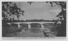
The Foot Bridge in City Park, Winnipeg, Manitoba
Fait partie de City of Winnipeg Archives Photograph collection
Photograph shows the foot bridge across the Assiniboine River in City Park. Date of photograph is approximate, ca. 1940.
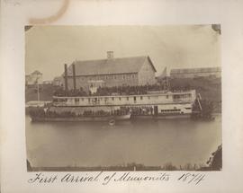
First arrival of Mennonites, 1874
Fait partie de City of Winnipeg (1874-1971)

Aerial of 1974 Flood – Pritchard Avenue Boat Dock and Redwood Bridge
Fait partie de City of Winnipeg Archives Photograph collection
Aerial photograph of the Red River during the 1974 Flood. The photograph faces northwest towards the North End, with the Pritchard Avenue Boat Dock in the bottom left and the Redwood Bridge in the top right. The photographs were taken by the Department of Environmental Planning.
Sans titre

Aerial of 1974 Flood – Fraser’s Grove Park
Fait partie de City of Winnipeg Archives Photograph collection
Aerial photograph of the Red River during the 1974 Flood. The photograph faces southwest from Fraser’s Grove Park and Kildonan Drive in East Kildonan towards Scotia Street in the Seven Oaks area of West Kildonan. The photographs were taken by the Department of Environmental Planning.
Sans titre

Aerial of 1974 Flood – Red River between East and West Kildonan
Fait partie de City of Winnipeg Archives Photograph collection
Aerial photograph of the Red River during the 1974 Flood. The photograph faces northwest from around Helmsdale Avenue and Kildonan Drive in East Kildonan towards Scotia Street in the Seven Oaks area of West Kildonan across the river. The photographs were taken by the Department of Environmental Planning.
Sans titre

Aerial of 1974 Flood – Bergen Cutoff Bridge
Fait partie de City of Winnipeg Archives Photograph collection
Aerial photograph of the Bergen Cutoff Bridge during the 1974 Flood. The photograph faces northwest from Kildonan Drive in North Kildonan across the Red River towards Kildonan Park and Old Kildonan. The photographs were taken by the Department of Environmental Planning.
Sans titre

Aerial of 1974 Flood – Red River between North and West Kildonan
Fait partie de City of Winnipeg Archives Photograph collection
Aerial photograph of the Red River during the 1974 Flood. The photograph faces west from North Kildonan, where the Chief Peguis Trail now stands, across the river towards Kildonan Park and West Kildonan on the left, the North End Water Treatment Plant in the middle, and Old Kildonan on the right. The photographs were taken by the Department of Environmental Planning.
Sans titre

Aerial photograph south of Winnipeg, east of Red River, 1943
Fait partie de City of Winnipeg Archives Photograph collection
Photograph shows an aerial view of south of Winnipeg, east of Red River. Photograph dated December 2, 1943.

Fait partie de City of Winnipeg Archives Photograph collection
Photograph shows an aerial view of the Red River north from the southern boundaries of North Kildonan and West St. Paul, north of Winnipeg. Photograph is dated December 2, 1943.

Aerial photograph south side of Assiniboine River, west from Assiniboine Park, 1943
Fait partie de City of Winnipeg Archives Photograph collection
Photograph shows an aerial view of the south side of the Assiniboine River, west from Assiniboine Park. Photograph is dated December 2, 1943.

Aerial photograph area west of Red River, south of Winnipeg City Limits, 1943
Fait partie de City of Winnipeg Archives Photograph collection
Photograph shows an aerial view of the area west of Red River, south of Winnipeg City Limits. Photograph is dated December 2, 1943.
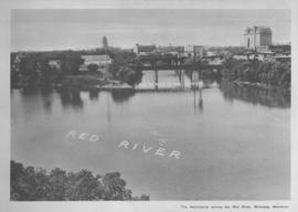
The Assiniboine River joining the Red River, Winnipeg, Manitoba
Fait partie de City of Winnipeg Archives Photograph collection
Print shows a photographic image of the Red and Assiniboine rivers joining at the Forks.

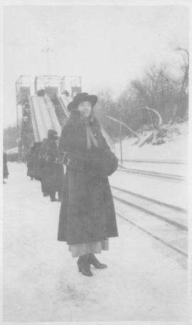
The Slide, Assiniboine River - 1918
Fait partie de City of Winnipeg Archives Photograph collection

Fait partie de City of Winnipeg Archives Photograph collection
Photograph is one of five photos mounted on page with caption "Assiniboine River flooded, Spring 1916."

Fait partie de City of Winnipeg Archives Photograph collection
Photograph is one of five photos mounted on page with caption "Assiniboine River flooded, Spring 1916."
![Assiniboine skating rink, ft. [?] of Kennedy Street - 1918](/uploads/r/city-of-winnipeg-archives-amp-records-control-branch/5/c/4/5c459682c313c672f73aaa83adbcc27373ee5977fea1a1ef42f5e5d1f62c9fc3/C0013_0000_0000_P0022_0095_068_142.jpg)
Assiniboine skating rink, ft. [?] of Kennedy Street - 1918
Fait partie de City of Winnipeg Archives Photograph collection
Maude on Assiniboine Rink - 1918
Fait partie de City of Winnipeg Archives Photograph collection
Shows Assiniboine River frozen over with woman (Maude) posing for photograph, toboggan slide in background. Taken in winter 1918.
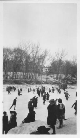
Kennedy Street skating rink, Winnipeg - 1918
Fait partie de City of Winnipeg Archives Photograph collection