

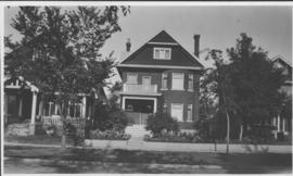
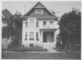
Apartment block at 415 Edison Avenue
- i04658
- Pièce
- [197-?]
Fait partie de City of Winnipeg Archives Photograph collection
Apartment block at 415 Edison Avenue, near Rothesay Street.
Apartment block at 415 Edison Avenue
Fait partie de City of Winnipeg Archives Photograph collection
Apartment block at 415 Edison Avenue, near Rothesay Street.
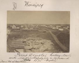
Point Douglas looking north with City Hall foundation in foreground, August 1875
Fait partie de City of Winnipeg (1874-1971)
Photograph taken from top of Courthouse.

Preliminary Report on Residential Areas - Metropolitan Plan for Greater Winnipeg
Fait partie de City Clerk's Library collection
Item consists of 1 report (60 pages), jointly prepared by the Metropolitan Planning Committee and Winnipeg Town Planning Commission. The report focuses on residential areas in the Greater Winnipeg Area. Part of the Metropolitan Plan for Greater Winnipeg - number 7 of master plan reports.
Sans titre
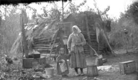
Only station woman on GWWD railway construction
Fait partie de Greater Winnipeg Water District fonds
Photograph of the only station woman for the construction of the Greater Winnipeg Water District Railway holding the hand of a child in front of a shelter, possibly near Shoal Lake. Photograph taken by C.J. Bruce, one of the Division Engineers for the Winnipeg Aqueduct.
Sans titre
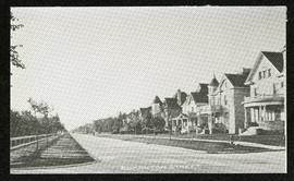
Fait partie de Morris Block collection
Photograph of houses on Edmonton Street, likely south of Portage Avenue.
Sans titre

Fait partie de City of Winnipeg (1874-1971)
A photograph of high water surrounding a causeway that ran to the Rover Street hydro station during the 1950 flood.
Sans titre

Aerial of 1974 Flood – Pritchard Avenue Boat Dock and Redwood Bridge
Fait partie de City of Winnipeg Archives Photograph collection
Aerial photograph of the Red River during the 1974 Flood. The photograph faces northwest towards the North End, with the Pritchard Avenue Boat Dock in the bottom left and the Redwood Bridge in the top right. The photographs were taken by the Department of Environmental Planning.
Sans titre

Aerial of 1974 Flood – Fraser’s Grove Park
Fait partie de City of Winnipeg Archives Photograph collection
Aerial photograph of the Red River during the 1974 Flood. The photograph faces southwest from Fraser’s Grove Park and Kildonan Drive in East Kildonan towards Scotia Street in the Seven Oaks area of West Kildonan. The photographs were taken by the Department of Environmental Planning.
Sans titre

Aerial of 1974 Flood – Red River between East and West Kildonan
Fait partie de City of Winnipeg Archives Photograph collection
Aerial photograph of the Red River during the 1974 Flood. The photograph faces northwest from around Helmsdale Avenue and Kildonan Drive in East Kildonan towards Scotia Street in the Seven Oaks area of West Kildonan across the river. The photographs were taken by the Department of Environmental Planning.
Sans titre

Aerial of 1974 Flood – Bergen Cutoff Bridge
Fait partie de City of Winnipeg Archives Photograph collection
Aerial photograph of the Bergen Cutoff Bridge during the 1974 Flood. The photograph faces northwest from Kildonan Drive in North Kildonan across the Red River towards Kildonan Park and Old Kildonan. The photographs were taken by the Department of Environmental Planning.
Sans titre

Aerial of 1974 Flood – Red River between North and West Kildonan
Fait partie de City of Winnipeg Archives Photograph collection
Aerial photograph of the Red River during the 1974 Flood. The photograph faces west from North Kildonan, where the Chief Peguis Trail now stands, across the river towards Kildonan Park and West Kildonan on the left, the North End Water Treatment Plant in the middle, and Old Kildonan on the right. The photographs were taken by the Department of Environmental Planning.
Sans titre
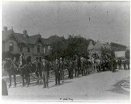
Horses and men leading novelty carriage
Fait partie de City of Winnipeg Archives Photograph collection
Photograph of a cavalcade of horses and men in suits leading a carriage made of hay[?] down an unknown, partially residential street.
Our place - 49 Balmoral Place, Winnipeg, Manitoba
Fait partie de City of Winnipeg Archives Photograph collection
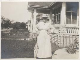
Neta Turner in front of house in Fort Garry, Winnipeg
Fait partie de City of Winnipeg Archives Photograph collection
Date of photograph is approximate, ca. 1918.
Fait partie de City of Winnipeg Archives Photograph collection
Date of photograph is approximate, ca. 1914.
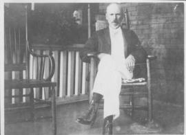
"Father" on verandah, 49 Balmoral Place, Winnipeg
Fait partie de City of Winnipeg Archives Photograph collection
Date of photograph is approximate, ca. 1914.
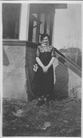
Mother in front of 49 Balmoral Place
Fait partie de City of Winnipeg Archives Photograph collection
Date of photograph is approximate, ca. 1918.
![Father and mother [49 Balmoral Place]](/uploads/r/city-of-winnipeg-archives-amp-records-control-branch/6/a/d/6ad2c1a8b9486cbfe21cba66d596d3b1d9875c7c4d56a3091ed073858611c0fc/C0013_0000_0000_P0022_0095_063_142.jpg)
Father and mother [49 Balmoral Place]
Fait partie de City of Winnipeg Archives Photograph collection
Date of photograph is approximate, ca. 1914.
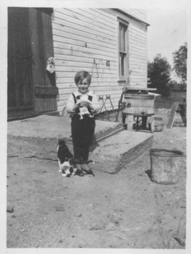
Elva, Manitoba, June 1918, Ken Furtney
Fait partie de City of Winnipeg Archives Photograph collection
Photograph shows child (Ken Furtney) holding kitten, wooden wash tub for laundry in background.
![A corner of our flower bed [146 Spence Street]](/uploads/r/city-of-winnipeg-archives-amp-records-control-branch/8/3/0/8303d86cfc1c3c535a8e5720f2911f54450e682e3755309c35bb6135bc015541/C0013_0000_0000_P0022_0095_055_142.jpg)
A corner of our flower bed [146 Spence Street]
Fait partie de City of Winnipeg Archives Photograph collection
Date of photograph is approximate, ca. 1914.