
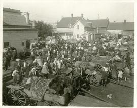
The North End market behind Dufferin Avenue and Derby Street
- i04002
- Item
- [ca. 1914]
Carts of goods and shoppers in a bustling market around Dufferin Avenue and Derby Street in the North End.
The North End market behind Dufferin Avenue and Derby Street
Carts of goods and shoppers in a bustling market around Dufferin Avenue and Derby Street in the North End.

Crane and David, Bakers and Confectioners
Staff standing in front of Crane and David Bakers and Confectioners at 765 Dufferin Avenue and a horse-drawn delivery cart.
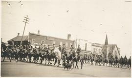
Photograph shows Lord Strathcona Horse, just before departure overseas during World War 1, at Selkirk and Main, looking at the east side of Main Street..

1932 Relief Works and Committee Winnipeg
Photograph collage of the 1932 Winnipeg Relief Works and Committee. Portraits of committee members are surrounding photographs of projects the committee had worked on. The committee members are, clockwise from top left: Alderman John Blumberg, Alderman H. Andrews, City Clerk Magnus Peterson, Alderman J.A. Barry, Alderman A.A. Ryley, Alderman W.B. Simpson, City Engineer W.P. Brereton, G.W. Northwood, Alderman E.D. Honeyman, Mayor Ralph Webb, Alderman J.A. McKerschar, A. MacNamara, Resident Engineer A.J. Taunton, Alderman L.F. Borrowman, and Alderman C.E. Simonite. The works projects showcased in the center are, clockwise from top left: the Main Street Bridge, the Norwood Bridge, the Assiniboine Park Bridge, the Winnipeg Auditorium, the Sargent Park Swimming Pool, and the Salter Street Bridge. Created by Robson Photo.
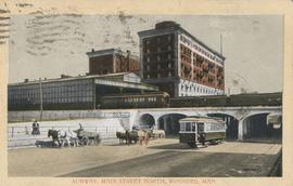
Subway, Main Street North, Winnipeg, Man.
Postcard shows C.P.R. Subway (Canadian Pacific Railway), looking south from Sutherland Avenue. Royal Alexandra Hotel and C.P.R. train sheds in view. Postmarked and note written on back. Date of postcard is uncertain, [before 1949].

Aerial view of Point Douglas, St. Boniface, and Elmwood areas
Aerial photograph of Point Douglas, St. Boniface, and west Elmwood.
![C.P.R. Yards looking West [Aerial view]](/uploads/r/city-of-winnipeg-archives-amp-records-control-branch/1/d/2/1d24b0471a50903dd76276838a7e169e4890a17020a9cfe6a0d34e153ebb9ec9/C0013_0000_0000_P0018_0027_001_142.jpg)
C.P.R. Yards looking West [Aerial view]
Inscription (on recto): WG A114 30-2-42 CPR [Canadian Pacific Railway] RR [Railroad] Yards looking West.
![Logan Avenue and Main Street [Aerial view]](/uploads/r/city-of-winnipeg-archives-amp-records-control-branch/d/9/2/d92728eee72f0ac3b14bbb8ea8f04c5d3ece08f19538ee5d078eb79492de602b/C0013_0000_0000_P0018_0034_001_142.jpg)
Logan Avenue and Main Street [Aerial view]
Inscription (on recto): A160 3-9-43 Logan Ave and Main St Wpg [Winnipeg] about 4000' 5".
![Vicinity of Elmwood Park [Aerial view]](/uploads/r/city-of-winnipeg-archives-amp-records-control-branch/5/b/9/5b929d618c2f619e557788462eee14587693511e7959bc6ca77ae96654d1bc98/C0013_0000_0000_P0018_0041_001_142.jpg)
Vicinity of Elmwood Park [Aerial view]
Inscription (on recto): WG M35: 3-15, 5 Mar '45, vicinity Elmwood Park Wpg, appr. scale 1/12000.
![Vicinity of Elmwood Park [Aerial view]](/uploads/r/city-of-winnipeg-archives-amp-records-control-branch/c/6/d/c6dc0bd0b8c2199f232fe8c7f5245d25e681a6a759be00e013a35a7a1ecada23/C0013_0000_0000_P0018_0042_001_142.jpg)
Vicinity of Elmwood Park [Aerial view]
Inscription (on recto): WG M35: 3-16, 5 Mar '45, vicinity Elmwood Park Wpg, appr scale 1/12000.

Central Business District: Aerial view - Central Winnipeg
Date of photograph is approximate, ca. 1947.