
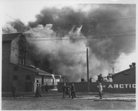
Arctic Ice Company's Bell Avenue yards fire, September 5, 1948
- i02336
- Item
- 1948
Stamp (on verso): Anderson-Brunnen Photographers, 410 Boyd Bldg. - Phone 93 900.
66 results with digital objects Show results with digital objects
Arctic Ice Company's Bell Avenue yards fire, September 5, 1948
Stamp (on verso): Anderson-Brunnen Photographers, 410 Boyd Bldg. - Phone 93 900.
Arthur and Fred Landen photograph album
Photograph album created by brothers Arthur and Fred Landen of Hull, England. Consists of circa 150 photographs of Arthur Landen’s time as Honourable Lieutenant and Quartermaster in the 1st Battalion of the Northumberland Fusiliers while stationed in Spain, Gibraltar, Egypt, and elsewhere in Africa between 1887 and 1907, as well as circa 40 photographs of Fred Landen’s stay in Winnipeg between 1903 and 1906 and his home in Hull, England. Winnipeg photographs feature homes, commercial buildings, and modes of transporation. The pages are loose and many of the photographs are faded.
Landen, Frederick Cluett
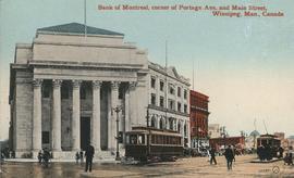
Bank of Montreal, corner of Portage Avenue and Main Street
Date of postcard is approximate, ca. 1912.

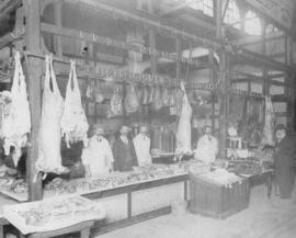
Butcher stall at public market
Item is a photographic reproduction, date unknown (original created 1884).

Butcher's turnout in Market Square
Photograph of a large group, many on horseback, gathered for what the photograph's caption calls a "butcher's turnout" at the northwest corner of King Street and Market Avenue (the north side of Market Square). Photograph was taken by Israel Bennetto and has come apart into two pieces.
Bennetto, Israel

City Hall and Union Bank, Winnipeg
Postcard shows Winnipeg's second city hall (1886-1962) and Union Bank building.

Clark’s Department Store at Highway 59 panorama
View of Clarks at Highway 59, southwest corner of Panet Road and Nairn Avenue, 8.5 acres. From left to right: B/A gas bar, Loblaws, Clarks Discount Store and Auto Centre, B/A gas bar, Kavanaugh's Hamburgers. Consists of 3 separate photographs pasted together on cardboard to create a panorama. The cardboard is a scrap made from an old sign of the Metropolitan Corporation of Greater Winnipeg (visible on the reverse). The cardboard is numbered “4”, presumably as part of a compilation with other shopping centre panoramas.
Metropolitan Corporation of Greater Winnipeg (Man.). Planning Division

Corner Portage Avenue and Main Street, Winnipeg, Manitoba
Print is a photographic image of the intersection of Portage Avenue and Main Street. Date of print is uncertain, [193-].

Crane and David, Bakers and Confectioners
Staff standing in front of Crane and David Bakers and Confectioners at 765 Dufferin Avenue and a horse-drawn delivery cart.

Crestview Shopping Centre panorama
View of Crestview Shopping Centre, 3395 Portage Avenue, 8.3 acres. From left to right: Kmart Department Store, Dominion Store, Various Shops. Consists of 3 separate photographs pasted together on cardboard to create a panorama. The cardboard is a scrap made from an old sign of the Metropolitan Corporation of Greater Winnipeg (visible on the reverse). The cardboard is numbered “9”, presumably as part of a compilation with other shopping centre panoramas.
Metropolitan Corporation of Greater Winnipeg (Man.). Planning Division

Crossroads Shopping Centre panorama
View of Crossroads Shopping Centre, 1580 Regent Avenue W., 18 acres. From left to right: Woolco Department Store, Various shops, Safeway, Pacific 66 Gas Bar. Consists of 3 separate photographs pasted together on cardboard to create a panorama. The cardboard is a scrap made from an old sign of the Metropolitan Corporation of Greater Winnipeg (visible on the reverse). The cardboard is numbered “3”, presumably as part of a compilation with other shopping centre panoramas.
Metropolitan Corporation of Greater Winnipeg (Man.). Planning Division

Dakota Village Shopping Centre panorama
View of Dakota Village Shopping Centre, 1077-1095 St. Mary's Road, 3.5 acres. From left to right: unknown stores, Ladies and Children's Wear, Lance Pharmacy, [Dakota?] Bowling, Shoe Fair, Bank of Nova Scotia, Safeway, apartment block, Bank of Montreal. Consists of 3 separate photographs pasted together on cardboard to create a panorama. The cardboard is a scrap made from an old sign of the Metropolitan Corporation of Greater Winnipeg (visible on the reverse). The cardboard is numbered “6”, presumably as part of a compilation with other shopping centre panoramas.
Metropolitan Corporation of Greater Winnipeg (Man.). Planning Division
Photograph shows Dufferin Avenue, east of the Arlington Bridge, in background. Date of photograph is approximate, ca. 1936.

Photograph shows Eaton's storefront decorated with flags as part of the Victory in Europe Day (VE Day) celebrations that marked the end of World War II in Europe.
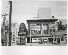
Existing Conditions, Corner of Graham and Donald looking East
A photograph of the southeast corner of Donald Street and Graham Avenue featuring a Moore's Taxi U Drive station in the foreground. Behind it in the background can be seen The Columbus Hall / Aragon Building with advertisements for Pepsi Cola and the Rainbow Dance Gardens, and the Tribune Building can be seen at the left. This is the present site of the Millennium Library. The back of the photo is marked: "Photograph 5. Existing Conditions, corner of Graham and Donald Looking East. Urban Renewal and Rehabilitation Board City of Winnipeg".
Winnipeg (Man.). Urban Renewal and Rehabilitation Board

Page shows five street views of Winnipeg, ca. 1903: 1) Main Street from Commercial Club, 2) Elgin Avenue, 3) Geo. Velie, Wholesale Wines and Liquors, 4) William Avenue, looking west, and 5) Main Street, looking north from Portage Avenue.
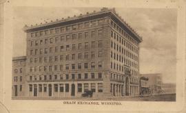
Grain Exchange building, 167 Lombard Avenue, Northeast corner of Rorie Street, ca. 1908
Date of postcard is approximate, ca. 1908.

Grant Plaza Shopping Centre panorama
View of Grant Park Plaza Shopping Centre, 1200-1216 Grant Avenue, 13.2 acres. From left to right: Clarks Discount Store, Dominion Store, Liquor Commission, Clarks Auto Centre. Consists of 3 separate photographs pasted together on cardboard to create a panorama. The cardboard is a scrap made from an old sign of the Metropolitan Corporation of Greater Winnipeg (visible on the reverse). The cardboard is numbered “8”, presumably as part of a compilation with other shopping centre panoramas.
Metropolitan Corporation of Greater Winnipeg (Man.). Planning Division
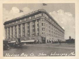
Hudson Bay Co., Store, Winnipeg, Man.
Photograph shows Hudson Bay Company Store at Portage Avenue and Memorial Boulevard. Date of photograph is approximate, ca. 1940.