

- i00131
- Item
- May 15, 1950
Part of City of Winnipeg (1874-1971)
A photograph of high water surrounding a causeway that ran to the Rover Street hydro station during the 1950 flood.
Harold K. White Studio
13 results with digital objects Show results with digital objects
Part of City of Winnipeg (1874-1971)
A photograph of high water surrounding a causeway that ran to the Rover Street hydro station during the 1950 flood.
Harold K. White Studio

Causeway to Rover Street Station
Part of City of Winnipeg (1874-1971)
A photograph of high water surrounding a causeway that ran to the Rover Street hydro station during the 1950 flood.
Harold K. White Studio

Part of City of Winnipeg (1874-1971)
A photograph of flooding on Disraeli St during the 1950 flood. The photograph shows a child standing on a pile of lumber beside the flooded street.
Harold K. White Studio

Part of City of Winnipeg (1874-1971)
A photograph of flooding in a residential area of Winnipeg during the 1950 flood. The photograph was taken at the intersection of Disraeli and Euclid.
Harold K. White Studio

Gladstone Street from Sutherland Avenue
Part of City of Winnipeg (1874-1971)
A photograph of flooding on Gladstone Street during the 1950 flood in Winnipeg. The photograph was taken from Sutherland Avenue.
Harold K. White Studio
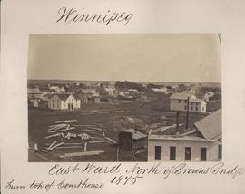
Winnipeg, East Ward, north of Browns Bridge, 1875
Part of City of Winnipeg (1874-1971)
Photograph taken from top of Courthouse.

Winnipeg, Main Street looking south, Spring of 1874
Part of City of Winnipeg (1874-1971)
Photograph taken from top of Courthouse.
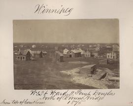
Winnipeg, West Ward, Point Douglas north of Browns Bridge, 1875
Part of City of Winnipeg (1874-1971)
Photograph taken from top of Courthouse.

Winnipeg, Main Street looking south, Summer 1875
Part of City of Winnipeg (1874-1971)
Photograph taken from top of Courthouse.

Point Douglas from Courthouse, 1874
Part of City of Winnipeg (1874-1971)
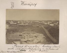
Point Douglas looking north with City Hall foundation in foreground, August 1875
Part of City of Winnipeg (1874-1971)
Photograph taken from top of Courthouse.

Part of East Ward, St. Boniface in the distance
Part of City of Winnipeg (1874-1971)
Photograph taken from top of Courthouse.
Part of City of Winnipeg (1874-1971)
Item is part of small album containing photographs of maps tracking the outbreak of typhoid from 1905 to 1908 and other scenes. Item is loose and at back of album. Date of item is approximate, [circa 1909].