
Plans for Capital Theatre, Donald Street
- i03862
- Item
- ca. 1920
Part of City of Winnipeg (1874-1971)
Winnipeg (Man.). City Engineer
4 results with digital objects Show results with digital objects
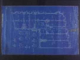
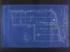
Plans for Capital Theatre, Donald Street
Part of City of Winnipeg (1874-1971)
Winnipeg (Man.). City Engineer
Plans for Underground Comfort Station
Part of City of Winnipeg (1874-1971)
Winnipeg (Man.). City Engineer
Plans for Remodeling of Old Elite Theatre for Mr. Robert Gens, 285 Portage Avenue
Part of City of Winnipeg (1874-1971)
Winnipeg (Man.). City Engineer
Proposed Plan for Wright Motors Ltd, corner of Portage Avenue and Canora Street
Part of City of Winnipeg (1874-1971)
Winnipeg (Man.). City Engineer
Plans for Men and Women’s Comfort Stations on Fort and Garry Streets, near Portage Avenue
Part of City of Winnipeg (1874-1971)
Winnipeg (Man.). City Engineer
Plans for Bascule Span, Main Street Bridge (Norwood Bridge)
Part of City of Winnipeg (1874-1971)
Winnipeg (Man.). City Engineer
Plans for Main Street Bridge (Norwood Bridge)
Part of City of Winnipeg (1874-1971)
Winnipeg (Man.). City Engineer
Plans for Norwood Bridge Original Stucture
Part of City of Winnipeg (1874-1971)
Winnipeg (Man.). City Engineer
Plans for Norwood Bridge Original Stucture
Part of City of Winnipeg (1874-1971)
Winnipeg (Man.). City Engineer
Plans for Norwood Bridge Original Stucture
Part of City of Winnipeg (1874-1971)
Winnipeg (Man.). City Engineer
Basement plans for 383-389 Portage Avenue and 290 Edmonton Street (The Edmonton Block)
Part of City of Winnipeg (1874-1971)
Blueprint plans of first floor of 383-389 Portage Avenue and 290 Edmonton Street (the Edmonton Block), designed by John. D. Atchison for W.H. Gardner. Drawing 2 of 5.
Atchison, John D.
First floor plans for 383-389 Portage Avenue and 290 Edmonton Street (The Edmonton Block)
Part of City of Winnipeg (1874-1971)
Blueprint plans of first floor of 383-389 Portage Avenue and 290 Edmonton Street (the Edmonton Block), designed by John. D. Atchison for W.H. Gardner. Drawing 2 of 6.
Atchison, John D.

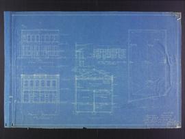
Floor plans for business premises of Mr. F.J. Sharpe, Portage Avenue
Part of City of Winnipeg (1874-1971)
Blueprint floor plans of the business premises of Mr. F.J. Sharpe on Portage Avenue. Designed by J.D. Atchison. Drawing 1 of 2. Originally drawn on May 10, 1919, but revised on July 14, 1919.
Atchison, John D.
Elevation plans for business premises of Mr. F.J. Sharpe, Portage Avenue
Part of City of Winnipeg (1874-1971)
Blueprint elevation plans of the business premises of Mr. F.J. Sharpe on Portage Avenue. Designed by J.D. Atchison. Drawing 2 of 2. Originally drawn on May 10, 1919, but revised on July 14, 1919.
Atchison, John D.
Part of City of Winnipeg (1874-1971)
Part of City of Winnipeg (1874-1971) fonds. Series consists of records created and maintained by the City Engineer and Engineering Department.
Winnipeg (Man.). City Engineer
City Engineering Department flood scrapbooks and photographs
Part of City of Winnipeg (1874-1971)
Series consists 6 subseries:
Subseries 53: Scrapbook A, 1948, 1950
Subseries 54: Scrapbook B, 1950
Subseries 55: Scrapbook [1950 flood photographs], 1950
Subseries 56: Scrapbook [1956 flood clippings], 1956
Subseries 57: Aerial photographs [1950 flood], 1949-1950
Subseries 58: 1950 flood photographs, 1950
Winnipeg (Man.). City Engineer
Part of City of Winnipeg (1874-1971)
Subseries consists of a scrapbook assembled by the City Engineering Department to document the 1948 flood and 1950 flood. It primarily contains clippings from newspapers like the Winnipeg Free Press and Winnipeg Tribune. Series also includes black and white photographs taken during the 1948 flood that show flooded areas by the Red River (e.g. Mill Street, Lombard Street, Arnold Avenue dyke, Elm Park Bridge, and St. Andrews Locks).
Newspaper coverage of the 1950 flood starts in Scrapbook A (April 4, 1950 to May 9, 1950) and continues in Scrapbook B (May 9, 1950 to August 16, 1950).
Winnipeg (Man.). City Engineer
Part of City of Winnipeg (1874-1971)
Subseries consists of a scrapbook assembled by the City Engineering Department to document the 1950 flood. It contains newspaper clippings from primarily the Winnipeg Free Press and Winnipeg Tribune. Clippings from the Illustrated London News also included.
Newspaper coverage of the 1950 flood starts in Scrapbook A (April 4, 1950 to May 9, 1950) and continues in Scrapbook B (May 9, 1950 to August 16, 1950).
Winnipeg (Man.). City Engineer
Scrapbook [1950 flood photographs]
Part of City of Winnipeg (1874-1971)
Subseries consists of a scrapbook assembled by the City Engineering Department to serve as photographic evidence of the 1950 flood. It contains black and white photographs that mostly document flooding in residential areas near the Red River (Fort Rouge, Riverview, North End, Point Douglas, Crescentwood, Armstrong's Point and others). Scrapbook appears to be organized geographically by area and street. In addition to documenting flooding, the photographs provide a detailed record of residential neighbourhoods, houses, streets, and businesses like corner grocery stores and laundries. All photographs were taken by Harold K. White Studio.
Winnipeg (Man.). City Engineer
Scrapbook [1956 flood clippings]
Part of City of Winnipeg (1874-1971)
Subseries consists of a scrapbook assembled by the City Engineering Department to document the 1956 flood. It contains clippings from newspapers like the Winnipeg Free Press and Winnipeg Tribune. Clippings start February 25, 1956 and end May 7, 1956.
Winnipeg (Man.). City Engineer