
![Father and mother [49 Balmoral Place]](/uploads/r/city-of-winnipeg-archives-amp-records-control-branch/6/a/d/6ad2c1a8b9486cbfe21cba66d596d3b1d9875c7c4d56a3091ed073858611c0fc/C0013_0000_0000_P0022_0095_063_142.jpg)
Father and mother [49 Balmoral Place]
- i02103
- Pièce
- 1914
Fait partie de City of Winnipeg Archives Photograph collection
Date of photograph is approximate, ca. 1914.
Father and mother [49 Balmoral Place]
Fait partie de City of Winnipeg Archives Photograph collection
Date of photograph is approximate, ca. 1914.
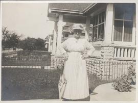
Mother in front of 49 Balmoral Place
Fait partie de City of Winnipeg Archives Photograph collection
Date of photograph is approximate, ca. 1918.
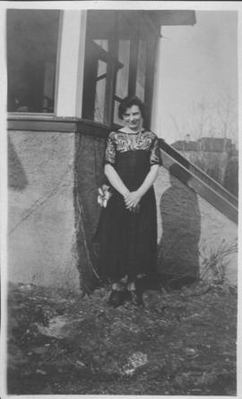
Neta Turner in front of house in Fort Garry, Winnipeg
Fait partie de City of Winnipeg Archives Photograph collection
Date of photograph is approximate, ca. 1918.
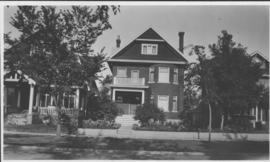
Our place - 49 Balmoral Place, Winnipeg, Manitoba
Fait partie de City of Winnipeg Archives Photograph collection

Preliminary Report on Residential Areas - Metropolitan Plan for Greater Winnipeg
Fait partie de City Clerk's Library collection
Item consists of 1 report (60 pages), jointly prepared by the Metropolitan Planning Committee and Winnipeg Town Planning Commission. The report focuses on residential areas in the Greater Winnipeg Area. Part of the Metropolitan Plan for Greater Winnipeg - number 7 of master plan reports.
Sans titre
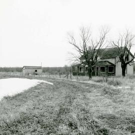
Area of John Blumberg Golf Course prior to construction.
Fait partie de Metropolitan Corporation of Greater Winnipeg
Photograph of abandoned buildings on a rural stretch of land in the area of what is now John Blumberg Golf Course. A description of the photo used for publication is recorded on a separate piece of paper. Photo's reverse is stamped by the Parks and Protection Division of the Metro Government.
Sans titre
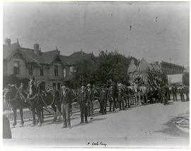
Horses and men leading novelty carriage
Fait partie de City of Winnipeg Archives Photograph collection
Photograph of a cavalcade of horses and men in suits leading a carriage made of hay[?] down an unknown, partially residential street.

Aerial of 1974 Flood – Red River between East and West Kildonan
Fait partie de City of Winnipeg Archives Photograph collection
Aerial photograph of the Red River during the 1974 Flood. The photograph faces northwest from around Helmsdale Avenue and Kildonan Drive in East Kildonan towards Scotia Street in the Seven Oaks area of West Kildonan across the river. The photographs were taken by the Department of Environmental Planning.
Sans titre

Aerial of 1974 Flood – Red River between North and West Kildonan
Fait partie de City of Winnipeg Archives Photograph collection
Aerial photograph of the Red River during the 1974 Flood. The photograph faces west from North Kildonan, where the Chief Peguis Trail now stands, across the river towards Kildonan Park and West Kildonan on the left, the North End Water Treatment Plant in the middle, and Old Kildonan on the right. The photographs were taken by the Department of Environmental Planning.
Sans titre

Aerial of 1974 Flood – Bergen Cutoff Bridge
Fait partie de City of Winnipeg Archives Photograph collection
Aerial photograph of the Bergen Cutoff Bridge during the 1974 Flood. The photograph faces northwest from Kildonan Drive in North Kildonan across the Red River towards Kildonan Park and Old Kildonan. The photographs were taken by the Department of Environmental Planning.
Sans titre

Aerial of 1974 Flood – Pritchard Avenue Boat Dock and Redwood Bridge
Fait partie de City of Winnipeg Archives Photograph collection
Aerial photograph of the Red River during the 1974 Flood. The photograph faces northwest towards the North End, with the Pritchard Avenue Boat Dock in the bottom left and the Redwood Bridge in the top right. The photographs were taken by the Department of Environmental Planning.
Sans titre

Aerial of 1974 Flood – Fraser’s Grove Park
Fait partie de City of Winnipeg Archives Photograph collection
Aerial photograph of the Red River during the 1974 Flood. The photograph faces southwest from Fraser’s Grove Park and Kildonan Drive in East Kildonan towards Scotia Street in the Seven Oaks area of West Kildonan. The photographs were taken by the Department of Environmental Planning.
Sans titre
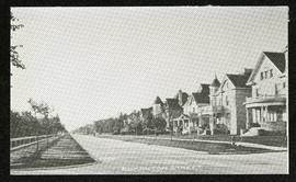
Fait partie de Morris Block collection
Photograph of houses on Edmonton Street, likely south of Portage Avenue.
Sans titre

Apartment block at 415 Edison Avenue
Fait partie de City of Winnipeg Archives Photograph collection
Apartment block at 415 Edison Avenue, near Rothesay Street.
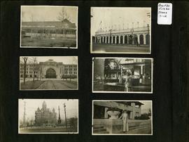
Photograph album of Winnipeg during WW1: Page 2
Fait partie de City of Winnipeg Archives Photograph collection
Item consists of a scrapbook page showing unidentified building (Item 7), Industrial Bureau Exhibition Building (Item 8), Canadian National Railway station (C.N.R. station) from Broadway looking east (Item 9), unidentified woman standing in front of residential building (Item 10), City Hall and Volunteer Monument (second City Hall) (Item 11), unidentified woman posing in front of what is likely the Assiniboine Park Pavilion (Item 12). Dates of photographs are approximate, [ca. 1913].

William Smaill Photo Album – Page 9
Fait partie de William Smaill fonds
Captions read: Station men's shack - Boggy number 1 - Hadashville - Settlers' house - Whitemouth - camp 3 - Indian Bay, April 1914.
Sans titre

William Smaill Photo Album – Page 13
Fait partie de William Smaill fonds
Captions read: Jackfish - Whitemouth - Trail, Indian Bay - Whitemouth - Birch River - Whitemouth - McLerie's.
Sans titre

William Smaill Photo Album – Page 19
Fait partie de William Smaill fonds
Captions read: Tomlison and Pleming's camp - Ballast trains - Birch River - Clearing land, Whtiemouth - Class 14 pads - Lidgerwood - Unloading boom - Camp 5, April 14 - Work train - McLerie's - Deacon - Hand cars - Culverts, mile 57 - Hunter and Jack Cumm
Sans titre
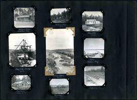
William Smaill Photo Album – Page 29
Fait partie de William Smaill fonds
Captions read: Engineer's camp, Birch River, mile 77 - Sailman's camp, mile 88 - Hospital, mile 77 - Bay City dredge, mile 89 - Pilot ditch, mile 89 - Dyke, Indian Bay - Engineer's camp, mile 88 - Tremblays camp 1 - Mile 85.5, '16.
Sans titre

William Smaill Photo Album – Page 37
Fait partie de William Smaill fonds
Captions read: Blaw Forms - Camp 2, Mile 57, Rear View - 8 foot clear muskeg - Camp 2, front view.
Sans titre