
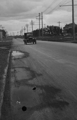
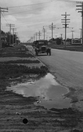
Main Street - Perth to Hartford, Rainfall, June 29, 1932
- i01383
- Pièce
- 1932
Fait partie de City of Winnipeg Archives Photograph collection
Photograph is dated July 1, 1932.
20 résultats avec objets numériques Afficher les résultats avec des objets numériques
Main Street - Perth to Hartford, Rainfall, June 29, 1932
Fait partie de City of Winnipeg Archives Photograph collection
Photograph is dated July 1, 1932.
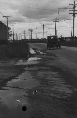
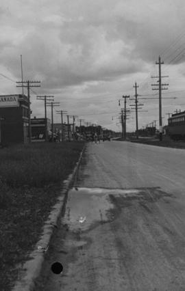
Main Street, corner Seven Oaks, Rainfall, June 29, 1932
Fait partie de City of Winnipeg Archives Photograph collection
Photograph is dated July 1, 1932.
Main Street - Perth to Hartford, Rainfall, June 29, 1932
Fait partie de City of Winnipeg Archives Photograph collection
Photograph is dated July 1, 1932.
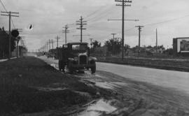
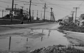
Main Street - Hartford to Belmont, 48 hours after rain
Fait partie de City of Winnipeg Archives Photograph collection
Date of photograph is July 1, 1932.
Main Street at Kilbridge, 48 hours after rain
Fait partie de City of Winnipeg Archives Photograph collection
Date of photograph is July 1, 1932.
Main Street at Belmont, 48 hours after rain
Fait partie de City of Winnipeg Archives Photograph collection
Date of photograph is July 8, 1932.
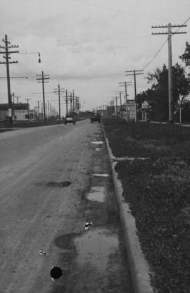
Main Street - Kilbridge to Burrin, Rainfall, June 29, 1932
Fait partie de City of Winnipeg Archives Photograph collection
Date of photograph is July 1, 1932.

Main Street, south of Seven Oaks, 48 hours after rain
Fait partie de City of Winnipeg Archives Photograph collection
Date of photograph is July 8, 1932.
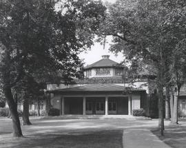
Fait partie de City of Winnipeg Archives Photograph collection
Photograph shows pavilion at Kildonan Park, a structure that was later demolished. Date of photograph is approximate, ca. 1920.
![Kildonan Park [Aerial view]](/uploads/r/city-of-winnipeg-archives-amp-records-control-branch/f/1/2/f128f88f8d2c2c0c11c754244bf269182c057eec594b0ca1962384f7a8471152/C0013_0000_0000_P0018_0036_001_142.jpg)
Fait partie de City of Winnipeg Archives Photograph collection
Inscription (on recto): WG M35: 2-16, 5 Mar '45, Kildonan Park Wpg [Winnipeg], appox scale 1/12000.
![Kildonan Park [Aerial view]](/uploads/r/city-of-winnipeg-archives-amp-records-control-branch/f/5/8/f589f26a584950aadbe5b101158e69cde3cad16f0f0cf05dcbb2a97e34661f16/C0013_0000_0000_P0018_0037_001_142.jpg)
Fait partie de City of Winnipeg Archives Photograph collection
Inscription (on recto): WG M35: 2-18, 5 Mar. '45, Kildonan Park, Wpg [Winnipeg], appr. scale 1/12000.
![Vicinity of Elmwood Park [Aerial view]](/uploads/r/city-of-winnipeg-archives-amp-records-control-branch/c/6/d/c6dc0bd0b8c2199f232fe8c7f5245d25e681a6a759be00e013a35a7a1ecada23/C0013_0000_0000_P0018_0042_001_142.jpg)
Vicinity of Elmwood Park [Aerial view]
Fait partie de City of Winnipeg Archives Photograph collection
Inscription (on recto): WG M35: 3-16, 5 Mar '45, vicinity Elmwood Park Wpg, appr scale 1/12000.

Woman standing beside large tree in Kildonan Park
Fait partie de City of Winnipeg Archives Photograph collection
Photograph shows unidentified woman posing next to large tree, taken during the fall season. One of three photos mounted on page with caption "Scenes - Kildonan Park." Date of photograph is probable, [1923?].
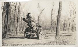
Woman sitting on artillery gun in Kildonan Park
Fait partie de City of Winnipeg Archives Photograph collection
Photograph shows unidentified woman sitting on a large artillery gun, taken during the fall season. One of three photos mounted on page with caption "Scenes - Kildonan Park." Date of photograph is probable, [1923?].
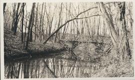
Fait partie de City of Winnipeg Archives Photograph collection
Photograph shows footbridge in wooded area, taken during the fall season. One of three photos mounted on page with caption "Scenes - Kildonan Park." Date of photograph is probable, [1923?].

Northgate Shopping Centre panorama
Fait partie de City of Winnipeg Archives Photograph collection
View of Northgate Plaza Shopping Centre, 1375-1425 McPhillips Street, 15 acres. From left to right: Clarks Discount Store, Various Shops, Northgate Bowling Lanes, Loblaw's. Consists of 3 separate photographs pasted together on cardboard to create a panorama. The cardboard is a scrap made from an old sign of the Metropolitan Corporation of Greater Winnipeg (visible on the reverse). The cardboard is numbered “14”, presumably as part of a compilation with other shopping centre panoramas.
Sans titre

Aerial of 1974 Flood – Red River between East and West Kildonan
Fait partie de City of Winnipeg Archives Photograph collection
Aerial photograph of the Red River during the 1974 Flood. The photograph faces northwest from around Helmsdale Avenue and Kildonan Drive in East Kildonan towards Scotia Street in the Seven Oaks area of West Kildonan across the river. The photographs were taken by the Department of Environmental Planning.
Sans titre

Aerial of 1974 Flood – Red River between North and West Kildonan
Fait partie de City of Winnipeg Archives Photograph collection
Aerial photograph of the Red River during the 1974 Flood. The photograph faces west from North Kildonan, where the Chief Peguis Trail now stands, across the river towards Kildonan Park and West Kildonan on the left, the North End Water Treatment Plant in the middle, and Old Kildonan on the right. The photographs were taken by the Department of Environmental Planning.
Sans titre

Aerial of 1974 Flood – Bergen Cutoff Bridge
Fait partie de City of Winnipeg Archives Photograph collection
Aerial photograph of the Bergen Cutoff Bridge during the 1974 Flood. The photograph faces northwest from Kildonan Drive in North Kildonan across the Red River towards Kildonan Park and Old Kildonan. The photographs were taken by the Department of Environmental Planning.
Sans titre

Aerial of 1974 Flood – Fraser’s Grove Park
Fait partie de City of Winnipeg Archives Photograph collection
Aerial photograph of the Red River during the 1974 Flood. The photograph faces southwest from Fraser’s Grove Park and Kildonan Drive in East Kildonan towards Scotia Street in the Seven Oaks area of West Kildonan. The photographs were taken by the Department of Environmental Planning.
Sans titre