
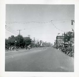
Winnipeg's 75th Anniversary parade - view of parade route
- i04313
- Pièce
- 6 Jun. 1949
Fait partie de City of Winnipeg Archives Photograph collection
Winnipeg's 75th Anniversary parade - view of parade route
Fait partie de City of Winnipeg Archives Photograph collection

Waghorn's Guide map and street index
Fait partie de City Clerk's Library collection
Waghorn's Guide - a small promotional pamphlet published by J.R. Waghorn in 1895. The pamphlet contains a street map of Winnipeg, a street index, and advertisements for various Winnipeg businesses including the Clarendon Hotel, the Redwood Brewery, and the Massey-Harris Company. The map shows the old City of Winnipeg from the Red River on the east to Waverly, Aubrey, and McPhillips Streets on the west, and from Athole Avenue (now Luxton Avenue) in the north to Parker Avenue in the south. Southern Elmwood, Old St. Boniface, and Norwood are also shown on the east side of the river. Railway lines are in black and electric street railway lines are in red.

Thoroughfares: Academy Road at Wellington Crescent
Fait partie de City of Winnipeg Archives Photograph collection
View of cars and cyclists heading down Academy Road towards Wellington Crescent and the Maryland Bridge. A small portion of Misericordia Hospital can be seen across the bridge.

Thoroughfares: Academy Road at Wellington Crescent
Fait partie de City of Winnipeg Archives Photograph collection
View of cars and cyclists heading down Academy Road towards Wellington Crescent and the Maryland Bridge. The cupola of Misericordia Hospital can be seen across the bridge.

Notre Dame Avenue facing west from Arlington Street
Fait partie de Parks and Recreation Photograph collection
View of the boulevard on Notre Dame Avenue facing west, between Arlington and McPhillips Streets. Free Press Depot Number 2 can be seen on the right.

New boulevards on street north from Palmerston Avenue.
Fait partie de Parks and Recreation Photograph collection
View of new boulevards on an unidentified street in the Wolseley area, facing north from Palmerston Avenue.

A military funeral, Broadway and Spence Streets, Winnipeg - 1914
Fait partie de City of Winnipeg Archives Photograph collection
Photograph taken at time of World War 1.
![Logan Avenue and Salter Street [Aerial view]](/uploads/r/city-of-winnipeg-archives-amp-records-control-branch/9/8/0/980f8ba4214d821c9b49366ae35d9ea9ed5b7f44366c5cd894e04befdd6c7a22/C0013_0000_0000_P0018_0033_001_142.jpg)
Logan Avenue and Salter Street [Aerial view]
Fait partie de City of Winnipeg Archives Photograph collection
Inscription (on recto): A161 3-9-43 Logan Ave and Salter St Wp [Winnipeg?] about 4000' 5".
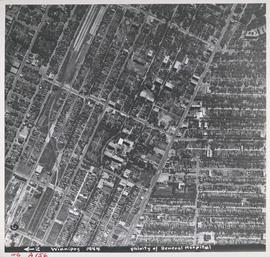
Aerial view of Vicinity of General Hospital, 1944
Fait partie de City of Winnipeg Archives Photograph collection
Description (on recto): WG A156, vicinity of General Hospital, Winnipeg, 1944. - Area around William Avenue and Sherbrook Street shown in photograph. - Photo credit: Royal Canadian Air Force Photograph.
#2, P.R.M., Westminster and Canora - 1947
Fait partie de City of Winnipeg Archives Photograph collection