

Part of East Ward, St. Boniface in the distance
- i00030
- Item
- 1875
Part of City of Winnipeg (1874-1971)
Photograph taken from top of Courthouse.
Part of East Ward, St. Boniface in the distance
Part of City of Winnipeg (1874-1971)
Photograph taken from top of Courthouse.
![Osborne, Asst. Chamberlain[?]](/uploads/r/city-of-winnipeg-archives-amp-records-control-branch/2/5/a/25a6e4d25b5924a851e738e37c5eeeee346740fbc679a8baf9ae65051b7d3c6d/F0001_0083_0000_A0569_0000_034_142.jpg)
Part of City of Winnipeg (1874-1971)
Date of photograph is probable, [1884?].
Bennetto, Israel
Part of City of Winnipeg (1874-1971)
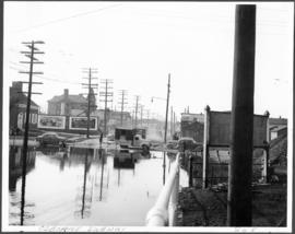
A photograph of an underpass on Osborne Street during the 1950 flood in Winnipeg.
Harold K. White Studio
Part of City of Winnipeg (1874-1971)
A photograph of an underpass on Osborne Street during the 1950 flood in Winnipeg.
Harold K. White Studio
Part of City of Winnipeg (1874-1971)
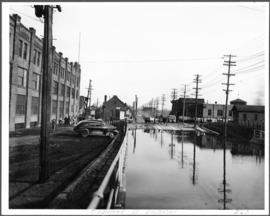
A photograph of the downstream Osborne Street Bridge during the 1950 flood in Winnipeg.
Harold K. White Studio

Part of City of Winnipeg (1874-1971)
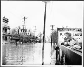
A photograph of the intersection of Broadway and Osborne Street during the 1950 flood in Winnipeg. The photo is taken from Osborne Street, looking north; the stone cross of All Saints' Church can be seen near the left side of the image.
Harold K. White Studio
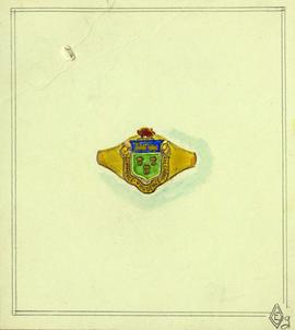
Original design for signet ring
Part of City of Winnipeg (1874-1971)
Winnipeg (Man.). Committee on Legislation and Reception

Part of City of Winnipeg (1874-1971)
A photograph of people boating down Oakwood Avenue in the Riverview neighbourhood during the 1950 flood in Winnipeg.
Harold K. White Studio
Part of City of Winnipeg (1874-1971)
A photograph of flooded Notre Dame Avenue East during the 1950 flood in Winnipeg.
Harold K. White Studio
Part of City of Winnipeg (1874-1971)
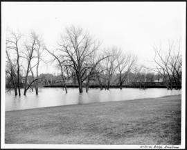
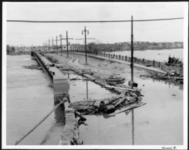
A photograph of the flooded Norwood Bridge during the 1950 flood in Winnipeg.
Harold K. White Studio
Part of City of Winnipeg (1874-1971)
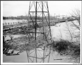
A photograph of a hydro tower and the flooded Norwood Bridge during the 1950 flood in Winnipeg.
Harold K. White Studio
Part of City of Winnipeg (1874-1971)
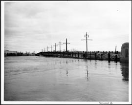
A photograph of the flooded Norwood Bridge during the 1950 flood in Winnipeg.
Harold K. White Studio

North side of Lombard, Rorie to Main Street
Part of City of Winnipeg (1874-1971)
A photograph of storefronts and advertisements on the north side of Lombard Avenue, between Rorie Street and Main Street. The photograph is part of small album containing photographs of maps tracking the outbreak of typhoid from 1905 to 1909 and other scenes. Item is loose and at back of album.

Part of City of Winnipeg (1874-1971)
A photograph of floodwater during the 1950 flood in Winnipeg. This photograph was taken looking north from the corner of Arnold Avenue and Hay Street; the Manitoba Legislature can be seen in the distance.
Harold K. White Studio

Part of City of Winnipeg (1874-1971)
Photograph shows the North End Farmer's Market (west side Main Street, north of Stella Avenue, looking west to King Street). Included in photograph: front entrance to market, automobiles parked on street, and North End Horse Exchange (523 King Street). Photograph likely taken from 919-921 Main Street by city employee.

Part of City of Winnipeg (1874-1971)
Photograph shows the North End Farmer's Market, looking east across Main Street (northwest Main Street and Stella Avenue). Included in photograph: stalls filled with vegetables and people walking through the market, Aime Bicycle Shop, 909 Main Street, two-storey brick building (899-905 Main Street), and Norquay School.
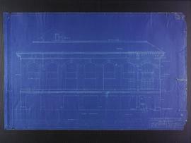
North elevation plans for the Club Building for the Columbus Hall Association
Part of City of Winnipeg (1874-1971)
Blueprint plans of north elevation of the Club Building for the Columbus Hall Association Ltd. on the southwest corner of Graham Avenue and Smith Street. Designed by John D. Atchison. Drawing 7 of 11.
Atchison, John D.
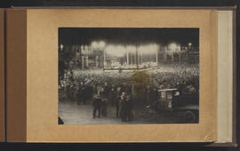
Night gathering for Winnipeg’s 50th anniversary
Part of City of Winnipeg (1874-1971)
Winnipeg (Man.). Special Jubilee Committee
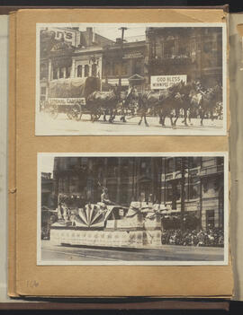
National Cartage and other float
Part of City of Winnipeg (1874-1971)
Winnipeg (Man.). Special Jubilee Committee
Part of City of Winnipeg (1874-1971)
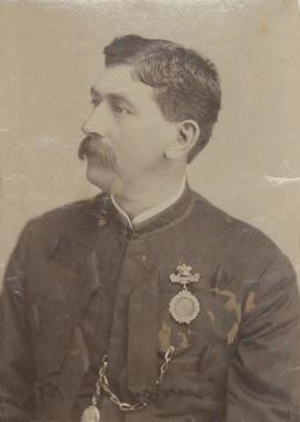
Photograph shows David B. Murray (1844-1908) who served as Police Chief from 1875 to 1887. Date of photograph is probable, [1884?].
Bennetto, Israel