

Winnipeg Street Railway on Portage Avenue in front of Merchants Hotel
- i01409
- Pièce
- [ca. 1886]
Fait partie de City of Winnipeg Archives Photograph collection
70 résultats avec objets numériques Afficher les résultats avec des objets numériques
Winnipeg Street Railway on Portage Avenue in front of Merchants Hotel
Fait partie de City of Winnipeg Archives Photograph collection
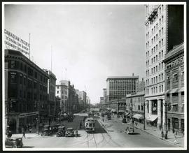
Portage Avenue looking west from Main Street
Fait partie de City of Winnipeg Archives Photograph collection
Date of photograph is approximate, ca. 1927.
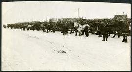
Unloading of relief wood at Greater Winnipeg Water District Station
Fait partie de City of Winnipeg Archives Photograph collection
Men at the Greater Winnipeg Water District station in St. Boniface standing in front of horses hauling wood piles for relief work. Photograph taken by Robinson Studio.
VE Day in Winnipeg showing Portage Avenue and Eaton's building in background
Fait partie de City of Winnipeg Archives Photograph collection
Photograph shows Victory in Europe Day (VE Day) celebrations marking the end of World War 2 in Europe.
Fait partie de City of Winnipeg Archives Photograph collection

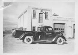
Delivery Truck, Lake of the Woods Milling Company
Fait partie de City of Winnipeg Archives Photograph collection
A delivery truck belonging to the Lake of the Woods Milling Company (later known as Five Roses Flour and merged with the Ogilvie Milling Company in 1954), which was based in Keewatin, Ontario.
Fait partie de City of Winnipeg Archives Photograph collection
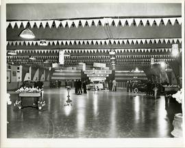
A car show likely held at the Civic Auditorium on Vaughan Street. Several cars are on display from brands such as Hudson and Austin.
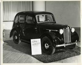
Austin Eight Saloon at car show
Fait partie de City of Winnipeg Archives Photograph collection
An Austin Eight Saloon model car at a car show likely held in the Civic Auditorium on Vaughan Street.
Fait partie de City of Winnipeg Archives Photograph collection
Photographs of buildings on Portage Avenue including the Bank of Montreal, Zeller's, the Power Building, Winnipeg Electric Co. and the Royal Bank Building.
Fait partie de City of Winnipeg Archives Photograph collection
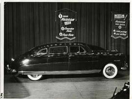
A Hudson brand car on display at a car show likely held in the Civic Auditorium on Vaughan Street. Banners advertiseing the Commodre and Super Series cars hang above.
Storefronts on Portage Avenue between Carlton and Hargrave Streets
Fait partie de City of Winnipeg Archives Photograph collection
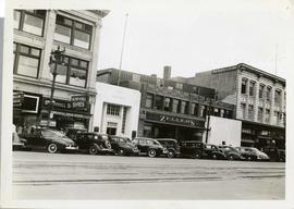
Cars and shoppers in front of stores on the north side of Portage Avenue, between Carlton and Hargrave Streets. Featured are The Berryhill Shoe Store in the Enderton / Mitchell-Copp Building, the Bank of Montreal, Zeller's (Zellers), and Rannards Shoes in

Portage Avenue looking west from Colony Street
Fait partie de City of Winnipeg Archives Photograph collection
A view of Portage Avenue looking west from Colony Street. The Hudson's Bay Company Building is featured prominantly and the Power Building and the Boyd Building are visible farther west.

Storefronts on Portage Avenue between Carlton and Hargrave Streets
Fait partie de City of Winnipeg Archives Photograph collection
Cars and shoppers in front of stores on the north side of Portage Avenue, between Carlton and Hargrave Streets. Featured are The Berryhill Shoe Store in the Enderton / Mitchell-Copp Building, the Bank of Montreal, and Zeller's (Zellers).

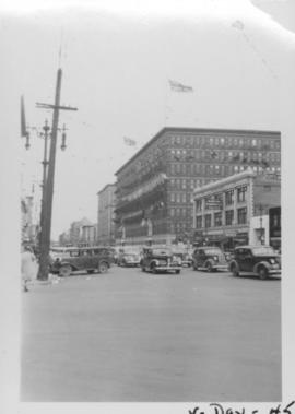
Portage Avenue looking west from Colony Street
Fait partie de City of Winnipeg Archives Photograph collection
A view of Portage Avenue looking west from Colony Street. The Hudson's Bay Company Building is featured prominantly and the Power Building is visible farther west. Playing "Young Mr. Lincoln", the Gaiety Theatre can be seen across the street with two poli
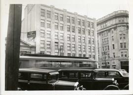
Storefronts in the Power Building
Fait partie de City of Winnipeg Archives Photograph collection
A view of cars and shoppers outside the Power Building at the corner of Portage Avenue and Vaughan Street. Street level storefronts include the Winnipeg Electric Company showroom and Rexall / Liggett's drug store. Above are the offices of Western Empire L
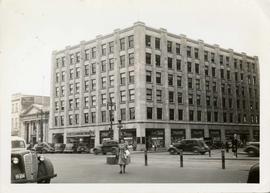
Power Building and Hudson's Bay Company Building
Fait partie de City of Winnipeg Archives Photograph collection
View of the North side of the corner of Portage Avenue and Vaughan Street, featuring the Power Building and Hudson's Bay Company Building. I front are parked cars and a street car passing by.
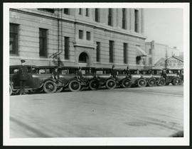
Police cars outside Rupert Avenue Police Station
Fait partie de City of Winnipeg Archives Photograph collection
A photograph of the Police Station and police car fleet on Rupert Avenue, taken ca. 1930.

Dakota Village Shopping Centre panorama
Fait partie de City of Winnipeg Archives Photograph collection
View of Dakota Village Shopping Centre, 1077-1095 St. Mary's Road, 3.5 acres. From left to right: unknown stores, Ladies and Children's Wear, Lance Pharmacy, [Dakota?] Bowling, Shoe Fair, Bank of Nova Scotia, Safeway, apartment block, Bank of Montreal. Consists of 3 separate photographs pasted together on cardboard to create a panorama. The cardboard is a scrap made from an old sign of the Metropolitan Corporation of Greater Winnipeg (visible on the reverse). The cardboard is numbered “6”, presumably as part of a compilation with other shopping centre panoramas.
Sans titre

Rossmere Shopping Centre panorama
Fait partie de City of Winnipeg Archives Photograph collection
View of Rossmere Shopping Centre, 1070 Henderson Highway, southwest corner Rowandale, 4.25 acres. From left to right: a garage or car wash, Red River Co-Op Store, Rossmere Lanes Bowling Alley, Library, Dry Cleaners, Co-operators Credit Union Society Limited, Rowandale Baptist Church, Rowandale Apartments, Red River Co-Op Gas Station. Consists of 3 separate photographs pasted together on cardboard to create a panorama. The cardboard is a scrap made from an old sign of the Metropolitan Corporation of Greater Winnipeg (visible on the reverse). The cardboard is numbered “2”, presumably as part of a compilation with other shopping centre panoramas.
Sans titre

Southgate Shopping Centre panorama
Fait partie de City of Winnipeg Archives Photograph collection
View of Southgate Village Shopping Centre, 1305-1341 Pembina Highway at the southwest corner of McGillivray Boulevard, 3.3 acres. From left to right: Pembina Curling Rink, Imperial Cleaners, Safeway, The Place, Young Togs, Reid Marshall Pharmacy, The Village Gift Shop, The French Salon, Marshall Wells, The Toronto Dominion Bank, Safeway gas bar. Consists of 3 separate photographs pasted together on cardboard to create a panorama. The cardboard is a scrap made from an old sign of the Metropolitan Corporation of Greater Winnipeg (visible on the reverse). The cardboard is numbered “7”, presumably as part of a compilation with other shopping centre panoramas.
Sans titre