

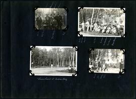
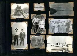
William Smaill Photo Album – Page 9
- p00127
- Part
- [Apr. 1914?]
Part of William Smaill fonds
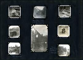
Captions read: Station men's shack - Boggy number 1 - Hadashville - Settlers' house - Whitemouth - camp 3 - Indian Bay, April 1914.
Smaill, William
William Smaill Photo Album – Page 9
Part of William Smaill fonds
Captions read: Station men's shack - Boggy number 1 - Hadashville - Settlers' house - Whitemouth - camp 3 - Indian Bay, April 1914.
Smaill, William
William Smaill Photo Album – Page 82
Part of William Smaill fonds
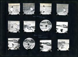
Captions read: Bruce, W.G. Chase [Chace], [?] H. Fuertes, Self, Sailman, Blanchard, Crawley, Richan - Walter, Bourne, Heywood, Miss Rust, Mrs. Waugh- Mrs. Blanchard, Miss Waugh, Mayor Waugh - Tennis court at Indian Bay - Bourne, Joe Nancy, Bell, Self.
Smaill, William

William Smaill Photo Album – Page 81
Part of William Smaill fonds
Captions read: Mayor R.D. Waugh, Indian Bay, 1915.
Smaill, William
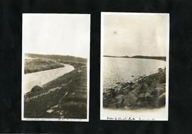
William Smaill Photo Album – Page 77
Part of William Smaill fonds
Captions read: Indian Bay, looking west from dyke.
Smaill, William
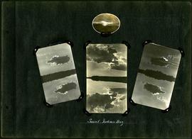
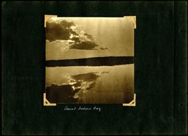
William Smaill Photo Album – Page 68
Part of William Smaill fonds
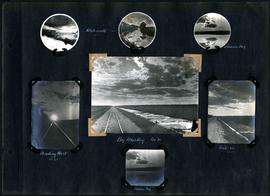
Captions read: Sunset, Indian Bay.
Smaill, William
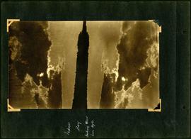
William Smaill Photo Album – Page 61
Part of William Smaill fonds
Captions read: Sunset, Indian Bay.
Smaill, William
William Smaill Photo Album – Page 49
Part of William Smaill fonds
Captions read: Jumbo[?], Indian Bay - Ruins of camp 1 built on Ontario gold concessions, Shoal Lake, 1896 - Jumbo - Teddy - Teddy, Whitemouth - Birch River railroad bridge - Chasing young ducks with launch, Shoal Lake.
Smaill, William
William Smaill Photo Album – Page 48
Part of William Smaill fonds
Captions read: Nancy Blanchard, Indian Bay - Bruce Smaill, Whitemouth River.
Smaill, William
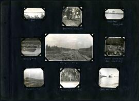
William Smaill Photo Album – Page 30
Part of William Smaill fonds
Captions read: Whitemouth - Indian Bay - Heading west, mile 68 - Big muskeg, mile 91 - Mile 89 - Indian Bay.
Smaill, William
William Smaill Photo Album – Page 29
Part of William Smaill fonds
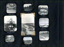
Captions read: Engineer's camp, Birch River, mile 77 - Sailman's camp, mile 88 - Hospital, mile 77 - Bay City dredge, mile 89 - Pilot ditch, mile 89 - Dyke, Indian Bay - Engineer's camp, mile 88 - Tremblays camp 1 - Mile 85.5, '16.
Smaill, William

William Smaill Photo Album – Page 15
Part of William Smaill fonds
Captions read: Anderson's dredge making cut between Indian Bay and Snowshoe Bay.
Smaill, William

William Smaill Photo Album – Page 13
Part of William Smaill fonds
Captions read: Jackfish - Whitemouth - Trail, Indian Bay - Whitemouth - Birch River - Whitemouth - McLerie's.
Smaill, William
William Smaill Photo Album – Page 108
Part of William Smaill fonds
Captions read: My car at mile 38 - Indian Bay - First crew to operate class 7 drag, C. Walgren, operator, [W.H.?] Smaill, fireman - Lassie, Hamish - Fisherman's Tug, Shoal Lake. Also contains a photo showing Kekekoziibii Shoal Lake 40 First Nation in the distance.
Smaill, William
William Smaill Photo Album – Page 106
Part of William Smaill fonds
Captions read: Dyke - Blanchard's, Indian Bay - Indian Camp, Shoal Lake [Kekekoziibii Shoal Lake 40 First Nation] - Removing arch - Camp 5, mile 77 - Remains after oil House fire, camp 5, mile 77 - Excursion train, camp 6 -Tennis court, Indian Bay - Young wild ducks.
Smaill, William
William Smaill Photo Album – loose page
Part of William Smaill fonds
Captions read: Completed aqueduct tube, Greater Winnipeg Water District - View of Shoal Lake, Greater Winnipeg Water District.
Smaill, William
William Smaill Photo Album – loose page
Part of William Smaill fonds
Captions read: Coal [dock?], Indian Bay, Greater Winnipeg Water District - Rock quarry, Greater Winnipeg Water District.
Smaill, William

William Smaill Photo Album – loose page
Part of William Smaill fonds
Captions read: Water tank, Indian Bay, Greater Winnipeg Water District.
Smaill, William
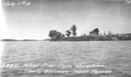
Treaty Grounds - Kekekoziibii Shoal Lake 40 First Nation
Photograph of Kekekoziibii (Shoal Lake 40) First Nation camp at Shoal Lake. Photograph taken from the Falcon River Diversion Dyke by William G. Chace, Chief Engineer of the Winnipeg Aqueduct.
Greater Winnipeg Water District
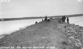
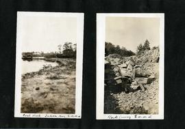
Riprapping west side of Falcon River Diversion Dyke at Indian Bay
Photograph of workers riprapping the west side of the Falcon River Diversion Dyke at Indian Bay. Photographer is unknown.
Greater Winnipeg Water District
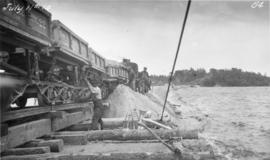
Placing material on Falcon River Diversion Dyke at Indian Bay
Photograph of workers using a scow to place material from cars onto the Falcon River Diversion Dyke at Indian Bay. Photograph taken by William G. Chace, Chief Engineer of the Winnipeg Aqueduct.
Greater Winnipeg Water District