
Aerial view looking south from over Wesley Park at rear of United College
- i01420
- Pièce
- 1937
Fait partie de City of Winnipeg Archives Photograph collection
Date of photograph is approximate, ca. 1937.
41 résultats avec objets numériques Afficher les résultats avec des objets numériques
Aerial view looking south from over Wesley Park at rear of United College
Fait partie de City of Winnipeg Archives Photograph collection
Date of photograph is approximate, ca. 1937.
Aerial view of Winnipeg looking south on Memorial Boulevard toward Legislative Building
Fait partie de City of Winnipeg Archives Photograph collection
Date of photograph is approximate, ca. 1935.

Aerial photograph south side of Assiniboine River, west from Assiniboine Park, 1943
Fait partie de City of Winnipeg Archives Photograph collection
Photograph shows an aerial view of the south side of the Assiniboine River, west from Assiniboine Park. Photograph is dated December 2, 1943.

Aerial photograph area west of Red River, south of Winnipeg City Limits, 1943
Fait partie de City of Winnipeg Archives Photograph collection
Photograph shows an aerial view of the area west of Red River, south of Winnipeg City Limits. Photograph is dated December 2, 1943.

Aerial view of Riverview, St. Vital, and Wildwood
Fait partie de City of Winnipeg Archives Photograph collection
Aerial view of the Riverview area of Fort Rouge, including Osborne Street; the Wildwood area of Fort Garry; and the Kingston Crescent, Elm Park, Varennes, St. George, and Glenlawn areas of St. Vital, including Kingston Row, St. Mary’s Road, and St. Anne’s Road.

Aerial of 1974 Flood – Bergen Cutoff Bridge
Fait partie de City of Winnipeg Archives Photograph collection
Aerial photograph of the Bergen Cutoff Bridge during the 1974 Flood. The photograph faces northwest from Kildonan Drive in North Kildonan across the Red River towards Kildonan Park and Old Kildonan. The photographs were taken by the Department of Environmental Planning.
Sans titre
![Northwest Winnipeg [Aerial view]](/uploads/r/city-of-winnipeg-archives-amp-records-control-branch/4/f/3/4f37bff68f08b53a6e7296217f26c266711570595702620b7b89d115744d09e4/C0013_0000_0000_P0018_0025_001_142.jpg)
Northwest Winnipeg [Aerial view]
Fait partie de City of Winnipeg Archives Photograph collection
Aerial view of the Minto area. Inscription (on recto): WG A90 '41, 1941 - Northwest Winnipeg.

Aerial view of Stevenson Field (Winnipeg Airport)
Fait partie de City of Winnipeg Archives Photograph collection
Inscription (on recto): NE WG F24 AP117 45:55N 97.14W Stevenson Field 27-9-43 15:55 8" 6000'.
![Kildonan Park [Aerial view]](/uploads/r/city-of-winnipeg-archives-amp-records-control-branch/f/1/2/f128f88f8d2c2c0c11c754244bf269182c057eec594b0ca1962384f7a8471152/C0013_0000_0000_P0018_0036_001_142.jpg)
Fait partie de City of Winnipeg Archives Photograph collection
Inscription (on recto): WG M35: 2-16, 5 Mar '45, Kildonan Park Wpg [Winnipeg], appox scale 1/12000.
![CNR Yards [Aerial view]](/uploads/r/city-of-winnipeg-archives-amp-records-control-branch/e/1/8/e184dce7e98d8a8fabf3b8481cfbdc63ba39898edb5f89746bd2e0a6795f8148/C0013_0000_0000_P0018_0045_001_142.jpg)
Fait partie de City of Winnipeg Archives Photograph collection
![Legislative Building and Central Winnipeg [Aerial view]](/uploads/r/city-of-winnipeg-archives-amp-records-control-branch/5/1/1/511af88a9e92fe7d7d3edda2bdaee6fc5652013532efb88411d3403dfcf85917/C0013_0000_0000_P0018_0046_001_142.jpg)
Legislative Building and Central Winnipeg [Aerial view]
Fait partie de City of Winnipeg Archives Photograph collection
Inscription (on recto): WG M35: 4-5, 5 Mar '45, Legislative Bldg and Central Wpg, appr. scale 1/12000.
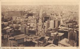
Street Scene, Winnipeg, Man., Canada
Fait partie de City of Winnipeg Archives Photograph collection
Item consists of a postcard in printed format that shows an aerial view of downtown Winnipeg, looking north up Main Street from Portage Avenue. Date of postcard is unknown.

Fait partie de City of Winnipeg Archives Photograph collection
An aerial view of East Kildonan between the roughly between the Red River and Watt Street, including Henderson Highway.

Fait partie de City of Winnipeg Archives Photograph collection
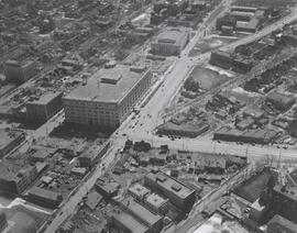
Photograph shows aerial view of downtown Winnipeg, looking north up Main Street from over Broadway and Main. Date of photograph is approximate, ca. 1924.

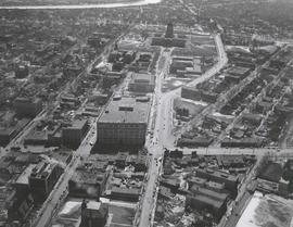
Central Business District: Aerial view - Central Winnipeg
Fait partie de City of Winnipeg Archives Photograph collection
Date of photograph is approximate, ca. 1947.
![Central Winnipeg between Portage and Notre Dame Avenues [Aerial view]](/uploads/r/city-of-winnipeg-archives-amp-records-control-branch/e/3/f/e3f90f80ff2b9d7dc2938509d7f4a5b4dfdfef9308ecfc0cfa38d5f1e2aa0bb8/C0013_0000_0000_P0018_0026_001_142.jpg)
Central Winnipeg between Portage and Notre Dame Avenues [Aerial view]
Fait partie de City of Winnipeg Archives Photograph collection
Inscription (on recto): WG A158 8/6/1942 Central Wpg between Portage and Notre Dame Ave's.

Fait partie de City of Winnipeg Archives Photograph collection
Photograph shows panoramic view of Winnipeg skyline. Date of photograph is approximate, ca. 1920.
![C.P.R. Yards looking West [Aerial view]](/uploads/r/city-of-winnipeg-archives-amp-records-control-branch/1/d/2/1d24b0471a50903dd76276838a7e169e4890a17020a9cfe6a0d34e153ebb9ec9/C0013_0000_0000_P0018_0027_001_142.jpg)
C.P.R. Yards looking West [Aerial view]
Fait partie de City of Winnipeg Archives Photograph collection
Inscription (on recto): WG A114 30-2-42 CPR [Canadian Pacific Railway] RR [Railroad] Yards looking West.
![East Kildonan [Aerial view]](/uploads/r/city-of-winnipeg-archives-amp-records-control-branch/8/6/0/860fdea3b1f6bcb68bd68a791365ae9deb8f9cd14834a8814d48663ae6ce80b6/C0013_0000_0000_P0018_0031_001_142.jpg)
Fait partie de City of Winnipeg Archives Photograph collection
Inscription (on recto): WG A155, East Kildonan - 1944.
![Logan Avenue and Salter Street [Aerial view]](/uploads/r/city-of-winnipeg-archives-amp-records-control-branch/9/8/0/980f8ba4214d821c9b49366ae35d9ea9ed5b7f44366c5cd894e04befdd6c7a22/C0013_0000_0000_P0018_0033_001_142.jpg)
Logan Avenue and Salter Street [Aerial view]
Fait partie de City of Winnipeg Archives Photograph collection
Inscription (on recto): A161 3-9-43 Logan Ave and Salter St Wp [Winnipeg?] about 4000' 5".