

Winnipeg, Main Street looking south, Spring of 1874
- i00036
- Pièce
- 1874
Fait partie de City of Winnipeg (1874-1971)
Photograph taken from top of Courthouse.
Winnipeg, Main Street looking south, Spring of 1874
Fait partie de City of Winnipeg (1874-1971)
Photograph taken from top of Courthouse.

Part of East Ward, St. Boniface in the distance
Fait partie de City of Winnipeg (1874-1971)
Photograph taken from top of Courthouse.

Fait partie de City of Winnipeg (1874-1971)
A photograph of flooding in a residential area of Winnipeg during the 1950 flood. The photograph was taken at the intersection of Disraeli and Euclid.
Sans titre

Fait partie de City of Winnipeg (1874-1971)
A photograph of high water surrounding a causeway that ran to the Rover Street hydro station during the 1950 flood.
Sans titre

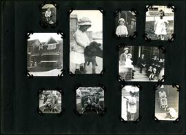
William Smaill Photo Album – Page 46
Fait partie de William Smaill fonds
Captions read: Vera S. - "EH?", "OH?" - Our home at Whitemouth River - Elsie.
Sans titre
William Smaill Photo Album – Page 90
Fait partie de William Smaill fonds
Captions read: Contains no captions.
Sans titre
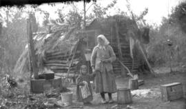
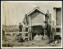
Only station woman on GWWD railway construction
Fait partie de Greater Winnipeg Water District fonds
Photograph of the only station woman for the construction of the Greater Winnipeg Water District Railway holding the hand of a child in front of a shelter, possibly near Shoal Lake. Photograph taken by C.J. Bruce, one of the Division Engineers for the Winnipeg Aqueduct.
Sans titre
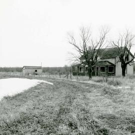
Area of John Blumberg Golf Course prior to construction.
Fait partie de Metropolitan Corporation of Greater Winnipeg
Photograph of abandoned buildings on a rural stretch of land in the area of what is now John Blumberg Golf Course. A description of the photo used for publication is recorded on a separate piece of paper. Photo's reverse is stamped by the Parks and Protection Division of the Metro Government.
Sans titre

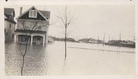
Floods - St. Boniface and Norwood - April 1916
Fait partie de City of Winnipeg Archives Photograph collection
Postcard is a photographic print showing water flooding homes. Photograph taken by Advance Photo Company, Winnipeg. Azo mark appears in stamp box, made in Canada.

Rue Langevin, St. Boniface under water floods April 1916, showing men in boat
Fait partie de City of Winnipeg Archives Photograph collection
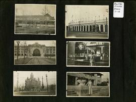
Photograph album of Winnipeg during WW1: Page 2
Fait partie de City of Winnipeg Archives Photograph collection
Item consists of a scrapbook page showing unidentified building (Item 7), Industrial Bureau Exhibition Building (Item 8), Canadian National Railway station (C.N.R. station) from Broadway looking east (Item 9), unidentified woman standing in front of residential building (Item 10), City Hall and Volunteer Monument (second City Hall) (Item 11), unidentified woman posing in front of what is likely the Assiniboine Park Pavilion (Item 12). Dates of photographs are approximate, [ca. 1913].
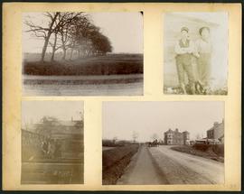
Arthur and Fred Landen photograph album – page 34
Fait partie de City of Winnipeg Archives Photograph collection
Page 34 of a photograph album created by brothers Arthur and Fred Landen of Hull, England. Page consists of 4 photographs taken by Fred Landen depicting, clockwise from top-left: a dirt road and field in Hull, England; two men posing for the camera in Hull, England; a horse drawn cart outside a large house in Hull, England; and a man and woman working in a garden in Hull, England.
Sans titre

Aerial of 1974 Flood – Red River between East and West Kildonan
Fait partie de City of Winnipeg Archives Photograph collection
Aerial photograph of the Red River during the 1974 Flood. The photograph faces northwest from around Helmsdale Avenue and Kildonan Drive in East Kildonan towards Scotia Street in the Seven Oaks area of West Kildonan across the river. The photographs were taken by the Department of Environmental Planning.
Sans titre

Aerial of 1974 Flood – Pritchard Avenue Boat Dock and Redwood Bridge
Fait partie de City of Winnipeg Archives Photograph collection
Aerial photograph of the Red River during the 1974 Flood. The photograph faces northwest towards the North End, with the Pritchard Avenue Boat Dock in the bottom left and the Redwood Bridge in the top right. The photographs were taken by the Department of Environmental Planning.
Sans titre

Aerial of 1974 Flood – Fraser’s Grove Park
Fait partie de City of Winnipeg Archives Photograph collection
Aerial photograph of the Red River during the 1974 Flood. The photograph faces southwest from Fraser’s Grove Park and Kildonan Drive in East Kildonan towards Scotia Street in the Seven Oaks area of West Kildonan. The photographs were taken by the Department of Environmental Planning.
Sans titre
Flood water over front porch of home, 1916 Flood, Norwood
Fait partie de City of Winnipeg Archives Photograph collection
Photograph shows scene from the 1916 flooding of the Assiniboine River in Norwood, flood water levels high enough to submerge front porch of home on left side of photograph.

Wildwood Park - Three weeks before flood, 1950
Fait partie de City of Winnipeg Archives Photograph collection
Fait partie de City of Winnipeg Archives Photograph collection
Date of photograph is approximate, ca. 1914.

Fait partie de City of Winnipeg (1874-1971)
A photograph of flooding on Disraeli St during the 1950 flood. The photograph shows a child standing on a pile of lumber beside the flooded street.
Sans titre
Fait partie de City of Winnipeg (1874-1971)
Item is part of small album containing photographs of maps tracking the outbreak of typhoid from 1905 to 1908 and other scenes. Item is loose and at back of album. Date of item is approximate, [circa 1909].