
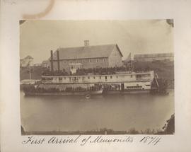
First arrival of Mennonites, 1874
- i00034
- Pièce
- 1874
Fait partie de City of Winnipeg (1874-1971)
First arrival of Mennonites, 1874
Fait partie de City of Winnipeg (1874-1971)

Footbridge in La Barriere Park
Fait partie de Metropolitan Corporation of Greater Winnipeg
Photograph of a footbridge across the La Salle River in La Barriere Park. A description of the photo used for publication is recorded on a separate piece of paper. Photo's reverse is stamped by the Parks and Protection Division of the Metro Government.
Sans titre
Fait partie de City of Winnipeg Archives Photograph collection
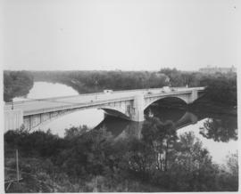
Photograph shows Maryland Street Bridge looking southeast into Crescentwood. Date of photograph is approximate, ca. 1925.
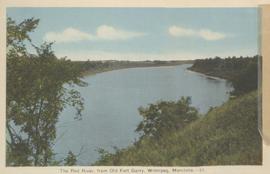
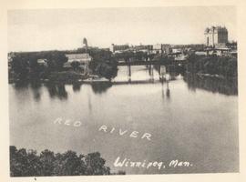
The Red River, from Old Fort Garry, Winnipeg, Manitoba
Fait partie de City of Winnipeg Archives Photograph collection
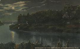
Moonlight on the Assiniboine River, Winnipeg, Man.
Fait partie de City of Winnipeg Archives Photograph collection
Date of postcard is uncertain, [before 1949].
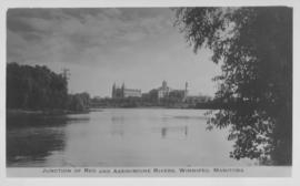
Junction of Red River and Assiniboine River
Fait partie de City of Winnipeg Archives Photograph collection
Photograph shows Fort Garry Hotel in background. Date of photograph is approximate, ca. 1940.
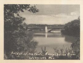
Bridge of the Forts, Assiniboine River, Winnipeg, Man.
Fait partie de City of Winnipeg Archives Photograph collection
Date of photograph is approximate, ca. 1940.

Aerial photograph south of Winnipeg, east of Red River, 1943
Fait partie de City of Winnipeg Archives Photograph collection
Photograph shows an aerial view of south of Winnipeg, east of Red River. Photograph dated December 2, 1943.

Fait partie de City of Winnipeg Archives Photograph collection
Photograph shows an aerial view of the Red River north from the southern boundaries of North Kildonan and West St. Paul, north of Winnipeg. Photograph is dated December 2, 1943.
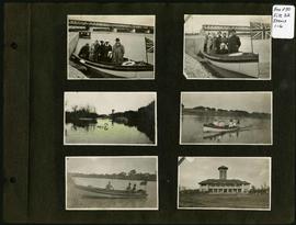
Photograph album of Winnipeg during WW1: Page 1
Fait partie de City of Winnipeg Archives Photograph collection
Item consists of a scrapbook page showing group of unidentified people in boat on river, possibly at Lockpart (Items 1 and 2), duck pond and pavilion at Assiniboine Park (Item 3), unidentified people in boat on river (Items 4 and 5), and pavilion at Assiniboine Park (Item 6). Dates of photographs are approximate, [ca. 1913].

Aerial of 1974 Flood – Red River between East and West Kildonan
Fait partie de City of Winnipeg Archives Photograph collection
Aerial photograph of the Red River during the 1974 Flood. The photograph faces northwest from around Helmsdale Avenue and Kildonan Drive in East Kildonan towards Scotia Street in the Seven Oaks area of West Kildonan across the river. The photographs were taken by the Department of Environmental Planning.
Sans titre

Aerial of 1974 Flood – Pritchard Avenue Boat Dock and Redwood Bridge
Fait partie de City of Winnipeg Archives Photograph collection
Aerial photograph of the Red River during the 1974 Flood. The photograph faces northwest towards the North End, with the Pritchard Avenue Boat Dock in the bottom left and the Redwood Bridge in the top right. The photographs were taken by the Department of Environmental Planning.
Sans titre

Aerial of 1974 Flood – Fraser’s Grove Park
Fait partie de City of Winnipeg Archives Photograph collection
Aerial photograph of the Red River during the 1974 Flood. The photograph faces southwest from Fraser’s Grove Park and Kildonan Drive in East Kildonan towards Scotia Street in the Seven Oaks area of West Kildonan. The photographs were taken by the Department of Environmental Planning.
Sans titre
Junction of Red and Assiniboine Rivers, Winnipeg, Manitoba
Fait partie de City of Winnipeg Archives Photograph collection
Date of photograph is approximate, ca. 1940.

Pontoon Bridge, Fort Garry and Warehouse from south side Assiniboine River
Fait partie de City of Winnipeg (1874-1971)

Fait partie de City of Winnipeg (1874-1971)
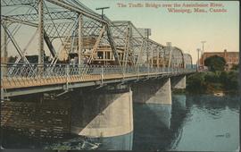
The Traffic Bridge over the Assiniboine River, Winnipeg
Fait partie de City of Winnipeg Archives Photograph collection
Date of postcard is uncertain, [before 1949].

Aerial photograph south side of Assiniboine River, west from Assiniboine Park, 1943
Fait partie de City of Winnipeg Archives Photograph collection
Photograph shows an aerial view of the south side of the Assiniboine River, west from Assiniboine Park. Photograph is dated December 2, 1943.

Aerial photograph area west of Red River, south of Winnipeg City Limits, 1943
Fait partie de City of Winnipeg Archives Photograph collection
Photograph shows an aerial view of the area west of Red River, south of Winnipeg City Limits. Photograph is dated December 2, 1943.

Arthur and Fred Landen photograph album – page 26
Fait partie de City of Winnipeg Archives Photograph collection
Page 26 of a photograph album created by brothers Arthur and Fred Landen of Hull, England. Page consists of 6 photographs taken by Fred Landen depicting, clockwise from top-left: Winnipeg’s second City Hall and the Volunteer Monument (which is captioned “Scott’s Monument, Fish Creek”); the Osborne Bridge over the Assiniboine River; a horse drawn sleigh carrying cords of wood in front of City Hall; a large house on Broadway, a dog sleigh in front of H. Laffrezen's Central Bakery at 333 1/2 William Avenue; and floating ice on the Assiniboine River.
Sans titre