

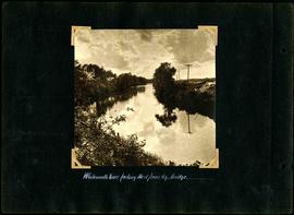
William Smaill Photo Album – Page 95
- p00213
- Part
- [1914 or 1915]
Part of William Smaill fonds
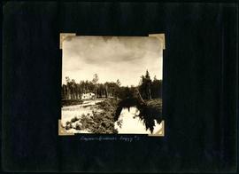
Captions read: Whitemouth River.
Smaill, William
27 results with digital objects Show results with digital objects
William Smaill Photo Album – Page 95
Part of William Smaill fonds
Captions read: Whitemouth River.
Smaill, William
William Smaill Photo Album – Page 90
Part of William Smaill fonds
Captions read: Contains no captions.
Smaill, William

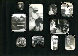
William Smaill Photo Album – Page 9
Part of William Smaill fonds
Captions read: Station men's shack - Boggy number 1 - Hadashville - Settlers' house - Whitemouth - camp 3 - Indian Bay, April 1914.
Smaill, William
William Smaill Photo Album – Page 65
Part of William Smaill fonds
Captions read: Whitemouth River looking west from railway bridge..
Smaill, William
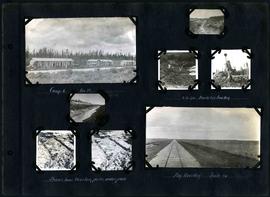
William Smaill Photo Album – Page 60
Part of William Smaill fonds
Captions read: Camp 5, mile 77.
Smaill, William
William Smaill Photo Album – Page 58
Part of William Smaill fonds
Captions read: Camp 6, mile 85 - 2 cubic yard bucket in muskeg - Shows how muskeg packs under pads - Big muskeg, mile 90.
Smaill, William

William Smaill Photo Album – Page 56
Part of William Smaill fonds
Captions read: Richan's house and ours at Whitemouth.
Smaill, William
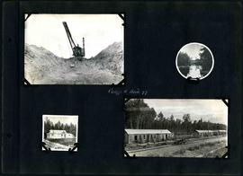
William Smaill Photo Album – Page 55
Part of William Smaill fonds
Captions read: Engineer's residence, boggy number 1.
Smaill, William

William Smaill Photo Album – Page 46
Part of William Smaill fonds
Captions read: Vera S. - "EH?", "OH?" - Our home at Whitemouth River - Elsie.
Smaill, William

William Smaill Photo Album – Page 37
Part of William Smaill fonds
Captions read: Blaw Forms - Camp 2, Mile 57, Rear View - 8 foot clear muskeg - Camp 2, front view.
Smaill, William
William Smaill Photo Album – Page 29
Part of William Smaill fonds
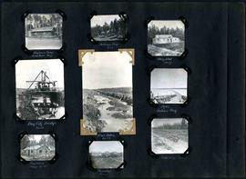
Captions read: Engineer's camp, Birch River, mile 77 - Sailman's camp, mile 88 - Hospital, mile 77 - Bay City dredge, mile 89 - Pilot ditch, mile 89 - Dyke, Indian Bay - Engineer's camp, mile 88 - Tremblays camp 1 - Mile 85.5, '16.
Smaill, William

William Smaill Photo Album – Page 19
Part of William Smaill fonds
Captions read: Tomlison and Pleming's camp - Ballast trains - Birch River - Clearing land, Whtiemouth - Class 14 pads - Lidgerwood - Unloading boom - Camp 5, April 14 - Work train - McLerie's - Deacon - Hand cars - Culverts, mile 57 - Hunter and Jack Cumm
Smaill, William

William Smaill Photo Album – Page 13
Part of William Smaill fonds
Captions read: Jackfish - Whitemouth - Trail, Indian Bay - Whitemouth - Birch River - Whitemouth - McLerie's.
Smaill, William
William Smaill Photo Album – Page 110
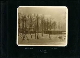
Part of William Smaill fonds
Captions read: Richan's house, our house, Reynolds, Manitoba.
Smaill, William

The second side of an album page with a photograph of a Parks Board supervised skating rink outside the Norhtland Knitting Company Building at 618 Arlington Street affixed.
Winnipeg (Man.). Parks and Recreation Department

The first side of an album page with a photograph of a Parks Board supervised skating rink outside Isaac Brock School and Chalmers United Church at Spruce Street and Barratt Avenue affixed.
Winnipeg (Man.). Parks and Recreation Department
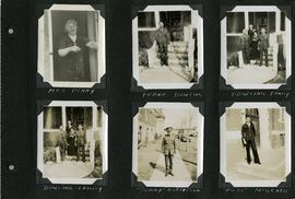
Scrapbook of Corporal Wallace – page 5
Page 5 of a photograph scrapbook made by Corporal John Wallace in April 1940. Photographs depict several acquaintenance of Wallace including two fellow soldiers, “Sonny” Robertson and Joseph “Fuss” McGrath, a Mrs. Penny, and a Frank Dowling and his family. See the general notes section for more details.
Wallace, John
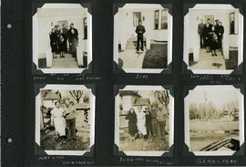
Scrapbook of Corporal Wallace – page 3
Page 3 of a photograph scrapbook made by Corporal John Wallace in April 1940. Photographs depict two families acquainted with Wallace: the Butlers (Jim Sr., Jim Jr., Les, Aggie, Gig, and Mrs. Butler) and the Drinkwaters (Mr. and Mrs. Drinkwater, Joan, Hilda, and Les), as well as Gladstone Manitoba. See general notes section for more details.
Wallace, John
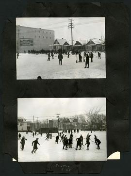
Two photographs of children playing hockey on outdoor skating rinks. Photo at top was taken outside the Northland Knitting Company building at 618 Arlington Street. Photo at bottom was taken on Scotia Street, near Luxton Avenue. The photographs are affixed to one side of a piece of construction paper that has two other photos on its reverse.
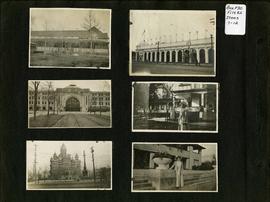
Photograph album of Winnipeg during WW1: Page 2
Item consists of a scrapbook page showing unidentified building (Item 7), Industrial Bureau Exhibition Building (Item 8), Canadian National Railway station (C.N.R. station) from Broadway looking east (Item 9), unidentified woman standing in front of residential building (Item 10), City Hall and Volunteer Monument (second City Hall) (Item 11), unidentified woman posing in front of what is likely the Assiniboine Park Pavilion (Item 12). Dates of photographs are approximate, [ca. 1913].