

Apartment block at 415 Edison Avenue
- i04658
- Item
- [197-?]
Apartment block at 415 Edison Avenue, near Rothesay Street.
957 results with digital objects Show results with digital objects
Apartment block at 415 Edison Avenue
Apartment block at 415 Edison Avenue, near Rothesay Street.
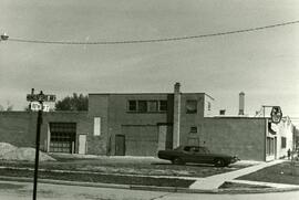
Shell station on Rothesay Street near Kingsford
Shell Service Station at the corner of Rothesay Street and Kingsford Avenue.
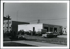
7-eleven and Shell station on Rothesay between Edison and Kingsford
7-Eleven store and Shell Service Station on Rothesay Street between Edison and Kingsford Avenues.
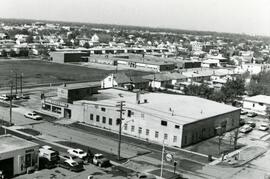
Strip mall on Rothesay at Kingsford
Springfield Heights Value Centre strip mall on Rothesay Street near Kingsford Avenue. Businesses include a barber shop, a pharmacy, Kwik Shop, and Penner’s Food.

Christmas lights along Portage, looking west from Donald
Christmas lights along Portage Avenue, looking west from around Donald Street. The Eaton’s Department Store is lit up on the left.
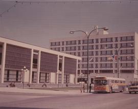
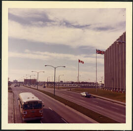
A photograph of the Civic Centre Complex, Winnipeg's third city hall (1964-present). Council Building, Administration Building, and public transit bus in view. Taken from William Avenue and Main Street, looking northwest. Date of photograph is uncertain, [197-?]. The photographer is likely Henry Kalen.
Kalen, Henry
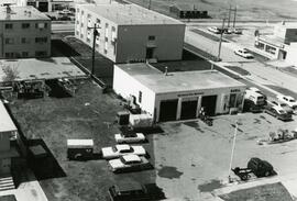
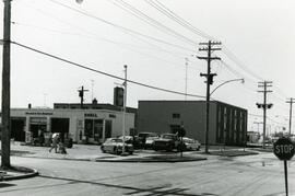
7-Eleven at the corner of Rothesay and Kingsford
Photograph of a 7-Eleven store at the corner of Rothesay Street and Kingsford Avenue.
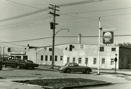
Shell station on Rothesay Street near Kingsford
Shell Service Station at the corner of Rothesay Street and Kingsford Avenue.
Shell station on Rothesay Street near Kingsford
Shell Service Station at the corner of Rothesay Street and Kingsford Avenue.
7-eleven and Shell station on Rothesay between Edison and Kingsford
7-Eleven store and sign of Shell Service Station on Rothesay Street between Edison and Kingsford Avenues.
Portage Avenue looking west from Empress Street
Portage Avenue in front of Manitoba Telephone Systems building on Empress Street, looking west.
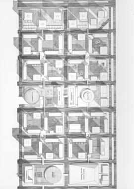
Downtown Winnipeg - Plan of St. Mary-Broadway Sector
Item shows drawing in printed format that records plans for downtown area.
Metropolitan Corporation of Greater Winnipeg (Man.). Planning Division

Downtown Winnipeg - Model photo of Downtown Plan (side view)
Item appears to show photographic reproduction of model (side view) in printed format that records plans for downtown area.
Metropolitan Corporation of Greater Winnipeg (Man.). Planning Division

Downtown Winnipeg - Section and Interior View of Winter Garden
Items shows drawing in printed format that record plans for downtown area.
Metropolitan Corporation of Greater Winnipeg (Man.). Planning Division
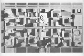
Downtown Winnipeg - Model Photo of Downtown Plan (aerial view)
Item appears to show photographic reproduction of model (aerial view) in printed format that records plans for downtown area.
Metropolitan Corporation of Greater Winnipeg (Man.). Planning Division

Item consists of a report cover for Downtown Winnipeg, created by the Metropolitan Corporation of Greater Winnipeg - Planning Division, April 1, 1969.
Metropolitan Corporation of Greater Winnipeg (Man.). Planning Division

Downtown Winnipeg - Isometric of St. Mary-Broadway Sector
Item shows drawing in printed format that records plans for downtown Winnipeg.
Metropolitan Corporation of Greater Winnipeg (Man.). Planning Division
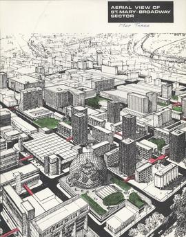
Downtown Winnipeg - Aerial view of St. Mary-Broadway Sector (Map Three)
Items shows drawing in printed format that record plans for downtown area.
Metropolitan Corporation of Greater Winnipeg (Man.). Planning Division
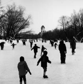
Skating Rink at the Assiniboine Park Duck Pond

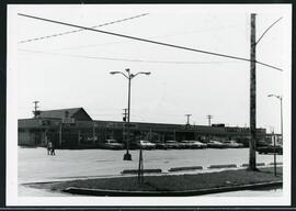
Dakota Village Shopping Centre panorama
View of Dakota Village Shopping Centre, 1077-1095 St. Mary's Road, 3.5 acres. From left to right: unknown stores, Ladies and Children's Wear, Lance Pharmacy, [Dakota?] Bowling, Shoe Fair, Bank of Nova Scotia, Safeway, apartment block, Bank of Montreal. Consists of 3 separate photographs pasted together on cardboard to create a panorama. The cardboard is a scrap made from an old sign of the Metropolitan Corporation of Greater Winnipeg (visible on the reverse). The cardboard is numbered “6”, presumably as part of a compilation with other shopping centre panoramas.
Metropolitan Corporation of Greater Winnipeg (Man.). Planning Division