
- i00260
- Item
- 1950
Part of City of Winnipeg (1874-1971)
A photograph taken during the 1950 flood, showing 42 Morley Avenue. Item is 1 of 8 photographs on page 10 of scrapbook.
Harold K. White Studio
78 results with digital objects Show results with digital objects
Part of City of Winnipeg (1874-1971)
A photograph taken during the 1950 flood, showing 42 Morley Avenue. Item is 1 of 8 photographs on page 10 of scrapbook.
Harold K. White Studio
From roof of Rover Sub Station. W.E. Co. Gas Plant
Part of City of Winnipeg (1874-1971)
A photograph of flooding, taken from the roof of the Rover Street hydro station, during the 1950 flood.
Harold K. White Studio
From 180 to 194 Bartlett Avenue
Part of City of Winnipeg (1874-1971)
A photograph taken during the 1950 flood, showing 180 Bartlett Avenue to 194 Bartlett Avenue. Item is 6 of 8 photographs on page 16 of scrapbook.
Harold K. White Studio
From 166 to 176 Bartlett Avenue
Part of City of Winnipeg (1874-1971)
A photograph taken during the 1950 flood, showing 166 Bartlett Avenue to 176 Bartlett Avenue. Item is 5 of 8 photographs on page 16 of scrapbook.
Harold K. White Studio
From 148 to 162 Bartlett Avenue
Part of City of Winnipeg (1874-1971)
A photograph taken during the 1950 flood, showing 148 Bartlett Avenue and 162 Bartlett Avenue. Item is 4 of 8 photographs on page 16 of scrapbook.
Harold K. White Studio
From 112 to 140 Bartlett Avenue
Part of City of Winnipeg (1874-1971)
A photograph taken during the 1950 flood, showing 112 Bartlett Avenue to 140 Bartlett Avenue. Item is 2 of 8 photographs on page 16 of scrapbook.
Harold K. White Studio

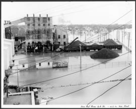
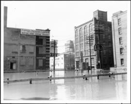
Foot of Robert Street (Galt Ave)
Part of City of Winnipeg (1874-1971)
A photograph of the Eaton's printing plant and warehouse on Robert Street (Galt Avenue) during the 1950 flood. The building is surrounded by a sandbag dike and water.
Harold K. White Studio
Flooding on the Red River towards St. Boniface.
Part of City of Winnipeg (1874-1971)
A photograph of the flooded Red River during the 1950 flood in Winnipeg. The photograph is taken looking toward St. Boniface.
Harold K. White Studio

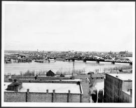
Flooding on the Red River aerial view looking down on the Provencher Bridge
Part of City of Winnipeg (1874-1971)
An aerial photograph of flooding during the 1950 flood in Winnipeg. The photograph is looking down on the Provencher Bridge and downtown Winnipeg.
Harold K. White Studio
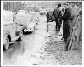
Part of City of Winnipeg (1874-1971)
A photograph of cars driving through floodwater and beside people working to build dikes during the 1950 flood in Winnipeg.
Harold K. White Studio
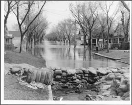
Flooding and diking in residential area
Part of City of Winnipeg (1874-1971)
A photograph of floodwater and sandbag dikes in a residential area during the 1950 flood in Winnipeg.
Harold K. White Studio
Flooding and diking in residential area
Part of City of Winnipeg (1874-1971)
A photograph of floodwater and sandbag dikes in a residential area during the 1950 flood in Winnipeg.
Harold K. White Studio
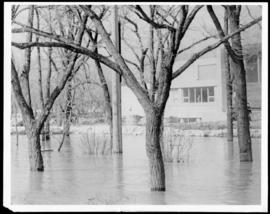
Part of City of Winnipeg (1874-1971)
A photograph of floodwater surrounding trees during the 1950 flood. A building protected by a sandbag dike is in the background.
Harold K. White Studio
Part of City of Winnipeg (1874-1971)
A photograph of floodwater surrounding the Canada Packers plant during the 1950 flood in Winnipeg.
Harold K. White Studio

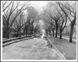
Part of City of Winnipeg (1874-1971)
A photograph of flooding in a residential area of Winnipeg during the 1950 flood. The photograph was taken at the intersection of Disraeli and Euclid.
Harold K. White Studio
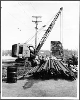
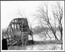
Part of City of Winnipeg (1874-1971)
A photograph of construction equipment and lumber at the Elm Park Bridge during the 1950 flood in Winnipeg.
Harold K. White Studio
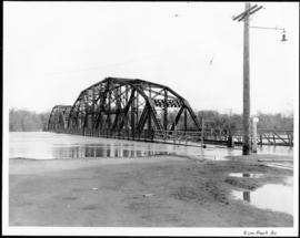
Part of City of Winnipeg (1874-1971)
A photograph of the Elm Park Bridge during the 1950 flood in Winnipeg.
Harold K. White Studio
Part of City of Winnipeg (1874-1971)
A photograph of the Elm Park Bridge during the 1950 flood in Winnipeg.
Harold K. White Studio
Part of City of Winnipeg (1874-1971)
A photograph taken during the 1950 flood, showing Eccles. Item is 7 of 7 photographs on page 13 of scrapbook.
Harold K. White Studio
Dyking built up around Shaarey Zedek Synagogue, 1950 Flood
Photograph taken at Shaarey Zedek Synagogue, 561 Wellington Crescent off Academy Road, on the western bank of the Assiniboine River. - Stamp (on verso): by Harold K. White Studio, 274 Fort St. Winnipeg, Phone 924 289.
Harold K. White Studio