
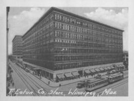
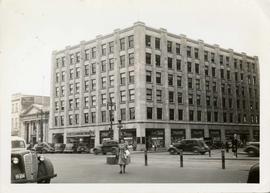
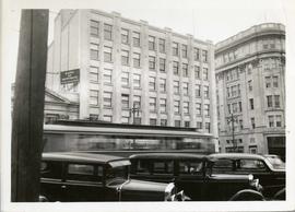
T. Eaton Co. Store, Winnipeg, Man.
- i01758
- Item
- 1940
Photograph shows Eaton's Department Store at Portage Avenue and Donald Street.
T. Eaton Co. Store, Winnipeg, Man.
Photograph shows Eaton's Department Store at Portage Avenue and Donald Street.
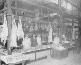
Butcher stall at public market
Item is a photographic reproduction, date unknown (original created 1884).

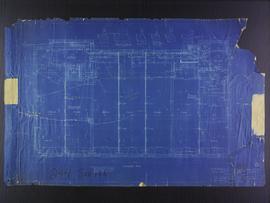
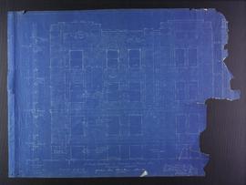
Roof plans for 383-389 Portage Avenue and 290 Edmonton Street (The Edmonton Block)
Part of City of Winnipeg (1874-1971)
Blueprint plans of roof of 383-389 Portage Avenue and 290 Edmonton Street (the Edmonton Block), designed by John. D. Atchison for W.H. Gardner. Drawing 4 of 6.
Atchison, John D.
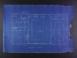
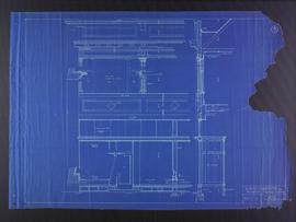
Basement plans the Club Building for the Columbus Hall Association
Part of City of Winnipeg (1874-1971)
Blueprint plans of basement of the Club Building for the Columbus Hall Association Ltd. on the southwest corner of Graham Avenue and Smith Street. Designed by John D. Atchison. Drawing 1 of 11.
Atchison, John D.
Fourth floor plans for the Club Building for the Columbus Hall Association
Part of City of Winnipeg (1874-1971)
Blueprint plans of fourth floor of the Club Building for the Columbus Hall Association Ltd. on the southwest corner of Graham Avenue and Smith Street. Designed by John D. Atchison. Drawing 5 of 11.
Atchison, John D.
Part of City of Winnipeg (1874-1971)
Blueprint plans of Kennedy street elevation of the Medical Arts Building at the corner of Graham Avenue and Kennedy Street. Designed by John D. Atchison. Drawing 4 of 6.
Atchison, John D.
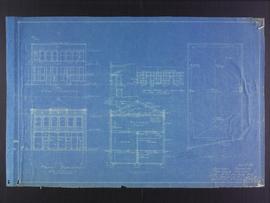
Facade plans for business premises for Mr. Nation, Portage Avenue
Part of City of Winnipeg (1874-1971)
Blueprint facade plans of the business premises of Mr. Nanton on Portage Avenue. Designed by J.D. Atchison. Drawing 3 of 3.
Atchison, John D.
Elevation plans for business premises of Mr. F.J. Sharpe, Portage Avenue
Part of City of Winnipeg (1874-1971)
Blueprint elevation plans of the business premises of Mr. F.J. Sharpe on Portage Avenue. Designed by J.D. Atchison. Drawing 2 of 2. Originally drawn on May 10, 1919, but revised on July 14, 1919.
Atchison, John D.

Photograph shows Eaton's storefront decorated with flags as part of the Victory in Europe Day (VE Day) celebrations that marked the end of World War II in Europe.
![Side view of Drug Store [Dunlop Drug Store - January 25, 1918]](/uploads/r/city-of-winnipeg-archives-amp-records-control-branch/9/7/c/97c0e1ca7dce9cc12cb7481bda6214c7c2576dd2fb09909be39f08f4404a5194/C0013_0000_0000_P0022_0095_047_142.jpg)

Corner Portage Avenue and Main Street, Winnipeg, Manitoba
Print is a photographic image of the intersection of Portage Avenue and Main Street. Date of print is uncertain, [193-].

The Cove Restaurant, corner of Portage and Carlton
Photograph of "The Cove" Restaurant at 355 Portage Avenue, at Carlton Street. The photograph was taken from a building on Carlton Street looking southeast towards the Eaton's Building, Mitchell-Copp, Zeller's, and the Carlton Building.
Storefronts in the Power Building
A view of cars and shoppers outside the Power Building at the corner of Portage Avenue and Vaughan Street. Street level storefronts include the Winnipeg Electric Company showroom and Rexall / Liggett's drug store. Above are the offices of Western Empire L
Power Building and Hudson's Bay Company Building
View of the North side of the corner of Portage Avenue and Vaughan Street, featuring the Power Building and Hudson's Bay Company Building. I front are parked cars and a street car passing by.

Southdale Shopping Centre panorama
View of Southdale Shopping Centre, 35 Lakewood Boulevard, 12.8 acres. From left to right: Dominion Store, Canadian Imperial Bank of Commerce, Mall Entrance, Quintons, Ebbeling Pharmacy, Kmart Department Store. Consists of 3 separate photographs pasted together on cardboard to create a panorama. The cardboard is a scrap made from an old sign of the Metropolitan Corporation of Greater Winnipeg (visible on the reverse). The cardboard is numbered “5”, presumably as part of a compilation with other shopping centre panoramas.
Metropolitan Corporation of Greater Winnipeg (Man.). Planning Division

Polo Park Shopping Centre panorama
View of Polo Park Shopping Centre, 1485 Portage Avenue, 41 acres. South side of shopping centre. Left to right: Winnipeg Motor Products, Motor Club, Simpson Sears Service Station, Simpson Sears Department Store. Consists of 3 separate photographs pasted together on cardboard to create a panorama. The cardboard is a scrap made from an old sign of the Metropolitan Corporation of Greater Winnipeg (visible on the reverse). The cardboard is numbered “13”, presumably as part of a compilation with other shopping centre panoramas.
Metropolitan Corporation of Greater Winnipeg (Man.). Planning Division

Arthur and Fred Landen photograph album – page 28
Page 28 of a photograph album created by brothers Arthur and Fred Landen of Hull, England. Page consists of 6 photographs taken by Fred Landen depicting, clockwise from top-left: bricklayers in front of houses; women on a horse-drawn sleigh (captioned “Cutter”); police in raccoon-skin uniforms; a streetcar crossing the Osborne Bridge; a Ox-drawn sleigh in front of the Royal Oak Hotel in Market Square (Market Avenue and King Street); and a woman pushing a baby in a sleigh in at the northwest corner of Broadway and Kennedy Street.
Landen, Frederick Cluett

North side of Lombard, Rorie to Main Street
Part of City of Winnipeg (1874-1971)
A photograph of storefronts and advertisements on the north side of Lombard Avenue, between Rorie Street and Main Street. The photograph is part of small album containing photographs of maps tracking the outbreak of typhoid from 1905 to 1909 and other scenes. Item is loose and at back of album.

City Hall and courtyard, facing Market Avenue
Photograph of the front side of Winnipeg's second City Hall, facing towards Market Avenue. Also featured in the photograph is the green space in front of City Hall, the Jubilee Fountain, the Volunteer Monument, businesses and store fronts on Market Avenue, and the McLaren and Cornwall Hotels in the distance. Photographed by Henry Kalen.
Metropolitan Corporation of Greater Winnipeg (Man.). Information Officer
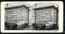
Eaton's promotional stereogram no. 3 – new grain exchange building, Winnipeg
Part of Morris Block collection
Block, Morris