
- i00141
- Item
- 1950
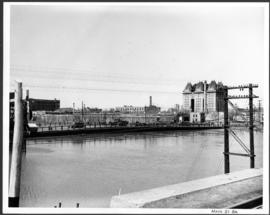
Part of City of Winnipeg (1874-1971)
A photograph of the Main Street Bridge during the 1950 flood in Winnipeg. The Hotel Fort Garry can be seen in the background.
Harold K. White Studio
Part of City of Winnipeg (1874-1971)
A photograph of the Main Street Bridge during the 1950 flood in Winnipeg. The Hotel Fort Garry can be seen in the background.
Harold K. White Studio

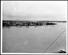
Flooding on the Red River aerial view looking down on the Provencher Bridge
Part of City of Winnipeg (1874-1971)
An aerial photograph of flooding during the 1950 flood in Winnipeg. The photograph is looking down on the Provencher Bridge and downtown Winnipeg.
Harold K. White Studio

Water Street Causeway to Provencher Bridge
Part of City of Winnipeg (1874-1971)
A photograph of vehicles driving down the Water Street causeway to the Provencher Bridge during the 1950 flood in Winnipeg.
Harold K. White Studio
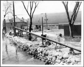
Part of City of Winnipeg (1874-1971)
A photograph of a pump and a sandbag dike during the 1950 flood in Winnipeg.
Harold K. White Studio

Part of City of Winnipeg (1874-1971)
A photograph of flooded Lombard Street during the 1950 flood in Winnipeg.
Harold K. White Studio

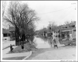
Bannerman and St. Cross looking east
Part of City of Winnipeg (1874-1971)
A photograph, looking east, of flooding at the intersection of Bannerman Avenue and St. Cross Street during the 1950 flood in Winnipeg.
Harold K. White Studio
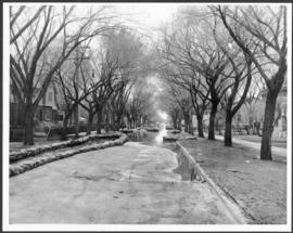
Part of City of Winnipeg (1874-1971)
A photograph, looking east, of flooding at the intersection of Atlantic Avenue and St. Cross Street during the 1950 flood in Winnipeg.
Harold K. White Studio
Flooding and diking in residential area
Part of City of Winnipeg (1874-1971)
A photograph of floodwater and sandbag dikes in a residential area during the 1950 flood in Winnipeg.
Harold K. White Studio

Part of City of Winnipeg (1874-1971)
A photograph of floodwater and sandbag dikes outside 368 and 372 Main Street during the 1950 flood in Winnipeg.
Harold K. White Studio
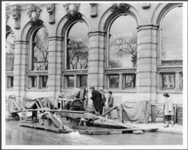
Part of City of Winnipeg (1874-1971)
A photograph of floodwater and a pump outside the Royal Bank on Main Street during the 1950 flood in Winnipeg.
Harold K. White Studio
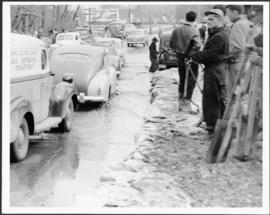
Part of City of Winnipeg (1874-1971)
A photograph of cars driving through floodwater and beside people working to build dikes during the 1950 flood in Winnipeg.
Harold K. White Studio
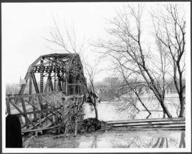
Part of City of Winnipeg (1874-1971)
A photograph of the Elm Park Bridge during the 1950 flood in Winnipeg.
Harold K. White Studio
Lyndale Drive from Pellissier Br. Roof
Part of City of Winnipeg (1874-1971)
A photograph of Lyndale Drive, surrounded by high floodwater, during the 1950 flood in Winnipeg.
Harold K. White Studio

Part of City of Winnipeg (1874-1971)
A photograph of floodwater during the 1950 flood in Winnipeg. This photograph was taken looking north from the corner of Arnold Avenue and Hay Street; the Manitoba Legislature can be seen in the distance.
Harold K. White Studio

Part of City of Winnipeg (1874-1971)
A photograph of flooded Assiniboine Avenue during the 1950 flood in Winnipeg.
Harold K. White Studio
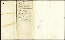
Volunteer Aid and Relief Fund Committee
Part of City of Winnipeg (1874-1971)
Series consists of two reports to Council regarding fund raising efforts and distribution of relief funds to the families of volunteers serving with the 90th Winnipeg Battalion of Rifles and the Winnipeg Field Battery during the North-West Rebellion (North-West Resistance) of 1885.
Winnipeg (Man.). Volunteer Aid and Relief Fund Committee
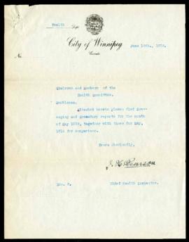
Scavenging and Crematory report for May, 1919
Part of City of Winnipeg (1874-1971)
A report from J.H. Pearson, Chief Health Inspector, to the Health Committee on scavenging and crematory operations for May, 1919. It records ammounts of refuse removed and cremated, dollars spent, and other statistics. There is also a comparison to May, 1918.
Winnipeg (Man.). Committee on Public Health and Welfare

Part of City of Winnipeg (1874-1971)
Photograph shows the North End Farmer's Market (west side Main Street, north of Stella Avenue, looking west to King Street). Included in photograph: front entrance to market, automobiles parked on street, and North End Horse Exchange (523 King Street). Photograph likely taken from 919-921 Main Street by city employee.

Part of City of Winnipeg (1874-1971)
Photograph shows the North End Farmer's Market, looking east across Main Street (northwest Main Street and Stella Avenue). Included in photograph: stalls filled with vegetables and people walking through the market, Aime Bicycle Shop, 909 Main Street, two-storey brick building (899-905 Main Street), and Norquay School.

Part of City of Winnipeg (1874-1971)
Photograph of the Winnipeg Renovating Co. and the Grain Exchange on Lombard Avenue. Item is part of small album containing photographs of maps tracking the outbreak of typhoid from 1905 to 1908 and other scenes. Item is loose and at back of album. Date of item is approximate, [circa 1909].