Showing 140 results

archival descriptions
Streets With digital objects
Print preview Hierarchy View:

Scrapbook of Corporal Wallace – page 6

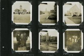
Page 6 of a photograph scrapbook made by Corporal John Wallace in April 1940. Photographs depict the Pavilion in City Park (Assiniboine Park), the Legislature Building off in the distance down Memorial Boulevard, St. Ignatius Church at Corydon Avenue and Stafford Street, the Winnipeg Cenotaph, and acquaintenances of Wallace, Mr. and Mrs. McCarthy and “Sister Sue”, and two people identified only as “Joan” and “Den”. See general notes section for more details.

Wallace, John

Looking west on Portage Avenue prior to the opening of the Portage and Main underground pedestrian concourse on February 23, 1979

Caption (on file): "Residents of Winnipeg who for a hundred years have fought the wintry winds at the corner of Portage and Main will now cross in summertime comfort with the provision of an environmentally controlled pedestrian concourse beneath Canada's most famous corner."

Allan, Hugh

Euclid and Barber

A photograph of flooding in a residential area of Winnipeg during the 1950 flood. The photograph was taken at the intersection of Disraeli and Euclid.

Harold K. White Studio

Portage and Main, looking west down Portage Avenue

Photograph of Portage Avenue looking west from the intersection at Main Street. Various shops and business are featured in buildings at Portage and Main that no longer exist, including the towering McArthur/Child's Building on the right. Photograph by Henry Kalen.

Metropolitan Corporation of Greater Winnipeg (Man.). Information Officer

For Your Guidance While in Winnipeg promotional map

A promotional map created by the Publicity Bureau of Winnipeg and Manitoba titled "For Your Guidance While in Winnipeg". Map was originally folded as a pamphlet, the front page of which features a graphic of two people driving down Highway 14 (now Highway 75) to Winnipeg. The map is not scale and features cartoon depictions of tourist destinations and landmarks around Winnipeg and St. Boniface. The maps shows major streets, railroads, and street railway lines. The map side was originally framed and cut to fit. At a result a small part of the front page is cut off, including a stamp reading "St. Raphael's Ukrainian Immigrants' Welfare Association of Can[ada]".

Block, Morris

Five street views

Page shows five street views of Winnipeg, ca. 1903: 1) Main Street from Commercial Club, 2) Elgin Avenue, 3) Geo. Velie, Wholesale Wines and Liquors, 4) William Avenue, looking west, and 5) Main Street, looking north from Portage Avenue.

Results 101 to 120 of 140