
William Smaill Photo Album – Page 39
- p00157
- Part
- [1914 or 1915]
Part of William Smaill fonds
Captions read: First setting up of inside forms, mile 51.
Smaill, William
70 results with digital objects Show results with digital objects
William Smaill Photo Album – Page 39
Part of William Smaill fonds
Captions read: First setting up of inside forms, mile 51.
Smaill, William
William Smaill Photo Album – Page 41
Part of William Smaill fonds
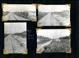
Captions read: Views at camp 3, mile 64.5.
Smaill, William
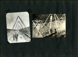
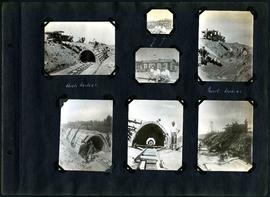
William Smaill Photo Album – Page 42
Part of William Smaill fonds
Captions read: Shows method of handling pads - shows method of support, class 7.
Smaill, William
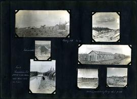
William Smaill Photo Album – Page 59
Part of William Smaill fonds
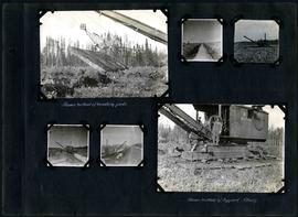
Captions read: Class 14 in muskeg, Mile 85 - First arch at camp 6, mile 85 - Handling Stumps - 10 foot muskeg.
Smaill, William
William Smaill Photo Album – Page 60
Part of William Smaill fonds
Captions read: Camp 5, mile 77.
Smaill, William
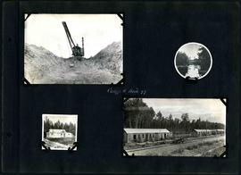
William Smaill Photo Album – Page 64
Part of William Smaill fonds
Captions read: Camp 1, mile 51 1/2.
Smaill, William
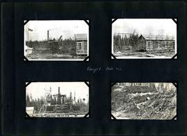
William Smaill Photo Album – Page 66
Part of William Smaill fonds
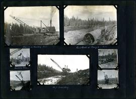
Captions read: Camp 4, Mile 71 - Incinerator - First foundation fill placed underwater, notice water still on sides - Hauling foundation fill up 4.5 % grade.
Smaill, William
William Smaill Photo Album – Page 73
Part of William Smaill fonds
Smaill, William
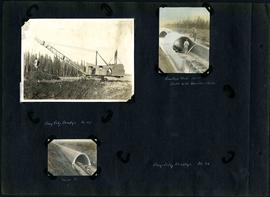
William Smaill Photo Album – Page 83
Part of William Smaill fonds
1 photograph appears to be missing. Captions read: Bay City dredge, mile 91 - Cracked arch, mile 85, broke with traveler sacks - Mile 58 - Bay City dredge, Mile 91.
Smaill, William
William Smaill Photo Album – Page 96
Part of William Smaill fonds
Captions read: Arch, mile 65 - Harold, Monty - Invert, mile 65.
Smaill, William

William Smaill Photo Album – loose page
Part of William Smaill fonds
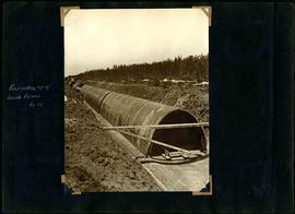
Captions read: Water tank, Indian Bay, Greater Winnipeg Water District.
Smaill, William
Fonds consists of a photo album created by William Smaill, Superintendent of the Winnipeg Aqueduct Construction Company, Ltd. The album contains photographs of the aqueduct’s construction, company men and their families, recreation, camps and homes used during construction, the Greater Winnipeg Water District Railway, and the surrounding landscape (Shoal Lake, Whitemouth River, Indian Bay, Birch River). There are also several photos of Winnipeg during Decoration Day 1914, photos of Mayors T.R. Deacon, Thomas Sharpe, and R.D. Waugh, and two photos of an Anishinaabe camp at Kekekoziibii Shoal Lake 40 First Nation.
The photos are heavily annotated. The annotations consist of names, locations, descriptions, and sometimes the section or specific mile of the aqueduct. A few photos appear to be missing and there are several loose pages with similar content. The photos are arranged somewhat chronologically – photos from 1914 generally precede photos from 1915 – but there are many exceptions.
Smaill, William