
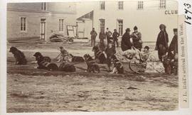
J. L. Reid's arrival from the west
- i00045
- Item
- 1873
Part of City of Winnipeg (1874-1971)
Dog sled shown in photograph.
521 results with digital objects Show results with digital objects
J. L. Reid's arrival from the west
Part of City of Winnipeg (1874-1971)
Dog sled shown in photograph.

Winnipeg Fire Brigade, July 1, 1875
Part of City of Winnipeg (1874-1971)
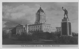
The Parliament Bldgs., Winnipeg, Manitoba
Photograph shows Parliament buildings (Manitoba Legislature) and Next of Kin Monument. Date of photograph is approximate, ca. 1940.
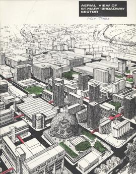
Downtown Winnipeg - Aerial view of St. Mary-Broadway Sector (Map Three)
Items shows drawing in printed format that record plans for downtown area.
Metropolitan Corporation of Greater Winnipeg (Man.). Planning Division
![Logan Avenue and Salter Street [Aerial view]](/uploads/r/city-of-winnipeg-archives-amp-records-control-branch/9/8/0/980f8ba4214d821c9b49366ae35d9ea9ed5b7f44366c5cd894e04befdd6c7a22/C0013_0000_0000_P0018_0033_001_142.jpg)
Logan Avenue and Salter Street [Aerial view]
Inscription (on recto): A161 3-9-43 Logan Ave and Salter St Wp [Winnipeg?] about 4000' 5".
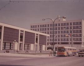
A photograph of the Civic Centre Complex, Winnipeg's third city hall (1964-present). Council Building, Administration Building, and public transit bus in view. Taken from William Avenue and Main Street, looking northwest. Date of photograph is uncertain, [197-?]. The photographer is likely Henry Kalen.
Kalen, Henry
Part of City of Winnipeg (1874-1971)
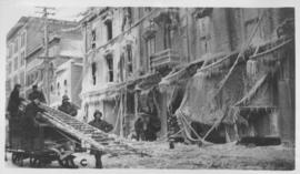
A photograph taken during the 1950 flood, showing 115 Notre Dame East. Item is 6 of 6 photographs on page 55 of scrapbook.
Harold K. White Studio
Part of City of Winnipeg (1874-1971)
A photograph taken during the 1950 flood, showing 43 Water Street. Item is 1 of 3 photographs on page 56 of scrapbook.
Harold K. White Studio
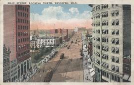
Main Street, looking north, Winnipeg, Man.
Postcard showing Main Street looking north from Bannatyne Avenue. Date of postcard is unknown.

Visit of Duke and Duchess of Cornwall & York (George V and Queen Mary)
Photograph showing an arch built near the C.P.R. Station in honour of a visit by the Duke and Duchess of Cornwall & York, George V and Queen Mary.

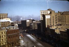
Corner Portage Avenue and Main Street, Winnipeg, Manitoba
Print is a photographic image of the intersection of Portage Avenue and Main Street. Date of print is uncertain, [193-].
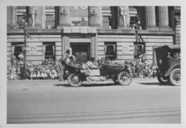
Automobile, clowns, Winnipeg's 75th Anniversary Parade
Photograph shows clowns riding in and on an automobile in front of the Canadian Bank of Commerce on Main Street during Winnipeg's 75th Anniversary Parade.
Scrapbook of Corporal Wallace – loose photo of St. Paul’s College
A loose photograph of Old St. Paul’s College on Ellice Avenue from a photograph scrapbook made by Corporal John Wallace in April 1940. The photograph is likely from page 4 of the scrapbook.
Wallace, John
Scrapbook of Corporal Wallace – page 7
Page 7 of a photograph scrapbook made by Corporal John Wallace in April 1940. Photographs depict Fort Osborne Barracks and its Parade Square, soldiers marching, the Civic Auditorium, and the Mall Hotel on Portage Avenue between Colony and Balmoral Streets.
Wallace, John

The Cove Restaurant, corner of Portage and Carlton
Photograph of "The Cove" Restaurant at 355 Portage Avenue, at Carlton Street. The photograph was taken from a building on Carlton Street looking southeast towards the Eaton's Building, Mitchell-Copp, Zeller's, and the Carlton Building.

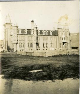
Photograph shows Winnipeg's second City Hall (1886-1952). Stamp (on verso) credits the photograph to the Geological Survey of Canada, No. 19549. Date of photograph is uncertain, [191-?].

Main Street looking northeast to Grace Methodist Church
Photograph of a muddy Main Street in 1871, facing northeast from around St. Mary Avenue. Featured on the photograph's right-hand side is Grace Methodist Church, located at Main Street and Water Avenue (now William Stephenson Way), which was opened on September 17 of that year.

Aerial view of Point Douglas, St. Boniface, and Elmwood areas
Aerial photograph of Point Douglas, St. Boniface, and west Elmwood.