
- p00308
- Part
- [ca. 1920]
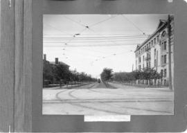
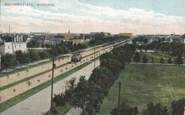
A photograph of streetcar on Broadway, looking west from Main Street. The Manitoba Club building can be seen on the left. Photographed by Steele and Company.
37 results with digital objects Show results with digital objects
A photograph of streetcar on Broadway, looking west from Main Street. The Manitoba Club building can be seen on the left. Photographed by Steele and Company.

Part of City of Winnipeg (1874-1971)
A photograph of the intersection of Broadway and Osborne Street during the 1950 flood in Winnipeg. The photo is taken from Osborne Street, looking north; the stone cross of All Saints' Church can be seen near the left side of the image.
Harold K. White Studio
Downtown Winnipeg - Plan of St. Mary-Broadway Sector
Item shows drawing in printed format that records plans for downtown area.
Metropolitan Corporation of Greater Winnipeg (Man.). Planning Division

Main interceptor looking toward curve, Broadway and Main St.
Photograph shows construction of sewer. Date of photograph is uncertain, [before 1949].

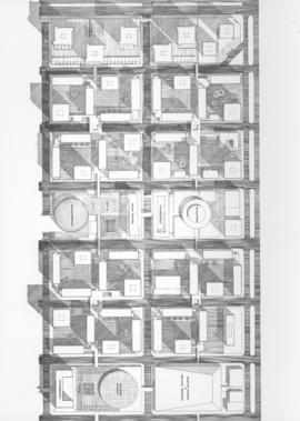
Downtown Winnipeg - Isometric of St. Mary-Broadway Sector
Item shows drawing in printed format that records plans for downtown Winnipeg.
Metropolitan Corporation of Greater Winnipeg (Man.). Planning Division
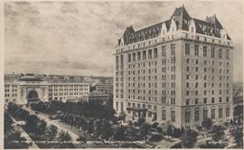
The Fort Garry Hotel and Union Station, Winnipeg, Manitoba
Date of postcard is uncertain, [before 1949].
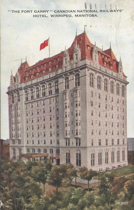
The Fort Garry Canadian National Railways' Hotel, Broadway and Fort Street
Date of postcard is approximate, ca. 1930.
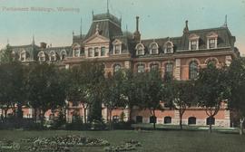
Parliament Buildings, Winnipeg
Postcard shows Provincial Parliament Building located on Kennedy Street, southwest corner of Broadway (former Manitoba Legislative Building, now demolished). Date of postcard is uncertain, [before 1921].
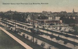
Broadway Avenue from Manitoba Club, Winnipeg
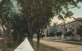
Broadway Methodist Church and Kennedy Street, Winnipeg
Date of postcard is uncertain, [before 1949].

C.N.R. Station, Winnipeg, Man.
Photograph shows Canadian National Railway Station situated on Main Street.

Union Station, Winnipeg, Manitoba
Photograph shows Canadian National Railway Station (C.N.R. Station) on Main Street. Date of photograph is approximate, ca. 1940.

Fort Garry Hotel, Winnipeg, Manitoba
Photograph shows Fort Garry Hotel on Broadway Avenue. Date of photograph is approximate, ca. 1940.
![Central Winnipeg between Portage and Notre Dame Avenues [Aerial view]](/uploads/r/city-of-winnipeg-archives-amp-records-control-branch/e/3/f/e3f90f80ff2b9d7dc2938509d7f4a5b4dfdfef9308ecfc0cfa38d5f1e2aa0bb8/C0013_0000_0000_P0018_0026_001_142.jpg)
Central Winnipeg between Portage and Notre Dame Avenues [Aerial view]
Inscription (on recto): WG A158 8/6/1942 Central Wpg between Portage and Notre Dame Ave's.
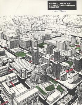
Downtown Winnipeg - Aerial view of St. Mary-Broadway Sector (Map Three)
Items shows drawing in printed format that record plans for downtown area.
Metropolitan Corporation of Greater Winnipeg (Man.). Planning Division
![Legislative Building and Central Winnipeg [Aerial view]](/uploads/r/city-of-winnipeg-archives-amp-records-control-branch/5/1/1/511af88a9e92fe7d7d3edda2bdaee6fc5652013532efb88411d3403dfcf85917/C0013_0000_0000_P0018_0046_001_142.jpg)
Legislative Building and Central Winnipeg [Aerial view]
Inscription (on recto): WG M35: 4-5, 5 Mar '45, Legislative Bldg and Central Wpg, appr. scale 1/12000.

A military funeral, Broadway and Spence Streets, Winnipeg - 1914
Photograph taken at time of World War 1.
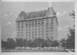
Fort Garry Hotel, Winnipeg, Manitoba, Canada
Print shows a photographic image of the Fort Garry Hotel.

Arthur and Fred Landen photograph album – page 26
Page 26 of a photograph album created by brothers Arthur and Fred Landen of Hull, England. Page consists of 6 photographs taken by Fred Landen depicting, clockwise from top-left: Winnipeg’s second City Hall and the Volunteer Monument (which is captioned “Scott’s Monument, Fish Creek”); the Osborne Bridge over the Assiniboine River; a horse drawn sleigh carrying cords of wood in front of City Hall; a large house on Broadway, a dog sleigh in front of H. Laffrezen's Central Bakery at 333 1/2 William Avenue; and floating ice on the Assiniboine River.
Landen, Frederick Cluett