
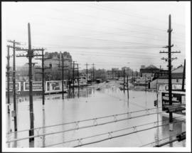
Main Street looking south from Main Street Bridge
- i00142
- Item
- 1950
Part of City of Winnipeg (1874-1971)
A photograph of flooded Main Street, looking south from the Main Street Bridge, during the 1950 flood in Winnipeg.
Harold K. White Studio
177 results with digital objects Show results with digital objects
Main Street looking south from Main Street Bridge
Part of City of Winnipeg (1874-1971)
A photograph of flooded Main Street, looking south from the Main Street Bridge, during the 1950 flood in Winnipeg.
Harold K. White Studio

Part of City of Winnipeg (1874-1971)
A photograph of floodwater and sandbag dikes outside 368 and 372 Main Street during the 1950 flood in Winnipeg.
Harold K. White Studio

Portage and Main, looking west down Portage Avenue
Photograph of Portage Avenue looking west from the intersection at Main Street. Various shops and business are featured in buildings at Portage and Main that no longer exist, including the towering McArthur/Child's Building on the right. Photograph by Henry Kalen.
Metropolitan Corporation of Greater Winnipeg (Man.). Information Officer
A photograph of streetcar on Broadway, looking west from Main Street. The Manitoba Club building can be seen on the left. Photographed by Steele and Company.

Winnipeg, Main Street looking south, Spring of 1874
Part of City of Winnipeg (1874-1971)
Photograph taken from top of Courthouse.

Part of City of Winnipeg (1874-1971)

Part of East Ward, St. Boniface in the distance
Part of City of Winnipeg (1874-1971)
Photograph taken from top of Courthouse.

Point Douglas from Courthouse, 1874
Part of City of Winnipeg (1874-1971)

Winnipeg, Main Street looking south, Summer 1875
Part of City of Winnipeg (1874-1971)
Photograph taken from top of Courthouse.

Part of City of Winnipeg (1874-1971)
Photograph shows the North End Farmer's Market (west side Main Street, north of Stella Avenue, looking west to King Street). Included in photograph: front entrance to market, automobiles parked on street, and North End Horse Exchange (523 King Street). Photograph likely taken from 919-921 Main Street by city employee.

Part of City of Winnipeg (1874-1971)
Photograph shows the North End Farmer's Market, looking east across Main Street (northwest Main Street and Stella Avenue). Included in photograph: stalls filled with vegetables and people walking through the market, Aime Bicycle Shop, 909 Main Street, two-storey brick building (899-905 Main Street), and Norquay School.
Part of City of Winnipeg (1874-1971)
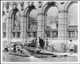
A photograph of floodwater and a pump outside the Royal Bank on Main Street during the 1950 flood in Winnipeg.
Harold K. White Studio

City Hall and courtyard, facing Market Avenue
Photograph of the front side of Winnipeg's second City Hall, facing towards Market Avenue. Also featured in the photograph is the green space in front of City Hall, the Jubilee Fountain, the Volunteer Monument, businesses and store fronts on Market Avenue, and the McLaren and Cornwall Hotels in the distance. Photographed by Henry Kalen.
Metropolitan Corporation of Greater Winnipeg (Man.). Information Officer

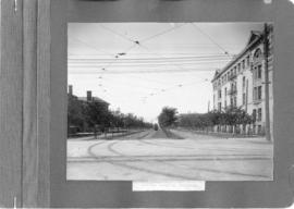
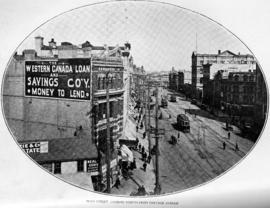
Main Street looking north from Portage Avenue
Part of City of Winnipeg (1874-1971)
Bentley Building, Courthouse and Artesian well shown in photograph.

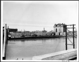
Pontoon Bridge, Fort Garry and Warehouse from south side Assiniboine River
Part of City of Winnipeg (1874-1971)
Part of City of Winnipeg (1874-1971)
A photograph of the Main Street Bridge during the 1950 flood in Winnipeg. The Hotel Fort Garry can be seen in the background.
Harold K. White Studio

Page shows five street views of Winnipeg, ca. 1903: 1) Main Street from Commercial Club, 2) Elgin Avenue, 3) Geo. Velie, Wholesale Wines and Liquors, 4) William Avenue, looking west, and 5) Main Street, looking north from Portage Avenue.
Main Street, looking north from Portage Avenue
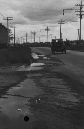
Main Street, corner Seven Oaks, Rainfall, June 29, 1932
Photograph is dated July 1, 1932.
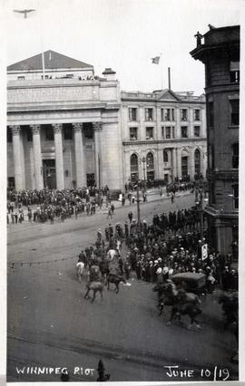
Scene from Winnipeg Strike 1919 – men on horseback at Portage and Main.