

- i00110
- Item
- 1967
Part of City of Winnipeg (1874-1971)
Winnipeg (Man.). Mayor's Office
3968 results with digital objects Show results with digital objects
Part of City of Winnipeg (1874-1971)
Winnipeg (Man.). Mayor's Office

Rossmere Shopping Centre panorama
View of Rossmere Shopping Centre, 1070 Henderson Highway, southwest corner Rowandale, 4.25 acres. From left to right: a garage or car wash, Red River Co-Op Store, Rossmere Lanes Bowling Alley, Library, Dry Cleaners, Co-operators Credit Union Society Limited, Rowandale Baptist Church, Rowandale Apartments, Red River Co-Op Gas Station. Consists of 3 separate photographs pasted together on cardboard to create a panorama. The cardboard is a scrap made from an old sign of the Metropolitan Corporation of Greater Winnipeg (visible on the reverse). The cardboard is numbered “2”, presumably as part of a compilation with other shopping centre panoramas.
Metropolitan Corporation of Greater Winnipeg (Man.). Planning Division

Southgate Shopping Centre panorama
View of Southgate Village Shopping Centre, 1305-1341 Pembina Highway at the southwest corner of McGillivray Boulevard, 3.3 acres. From left to right: Pembina Curling Rink, Imperial Cleaners, Safeway, The Place, Young Togs, Reid Marshall Pharmacy, The Village Gift Shop, The French Salon, Marshall Wells, The Toronto Dominion Bank, Safeway gas bar. Consists of 3 separate photographs pasted together on cardboard to create a panorama. The cardboard is a scrap made from an old sign of the Metropolitan Corporation of Greater Winnipeg (visible on the reverse). The cardboard is numbered “7”, presumably as part of a compilation with other shopping centre panoramas.
Metropolitan Corporation of Greater Winnipeg (Man.). Planning Division

Westwood Shopping Centre panorama
View of Westwood Shopping Centre, 3276-3332 Portage Avenue, 10.2 acres. From left to right: various shops, motel, various shops and Assiniboia Public Library, Safeway Store, Marshall Wells, Perths, Westwood Pharmacy, various Shops, Zeller's County Fair, Auto Centre. Consists of 3 separate photographs pasted together on cardboard to create a panorama. The cardboard is a scrap made from an old sign of the Metropolitan Corporation of Greater Winnipeg (visible on the reverse). The cardboard is numbered “10”, presumably as part of a compilation with other shopping centre panoramas.
Metropolitan Corporation of Greater Winnipeg (Man.). Planning Division
Council Minutes (English) - Typescript (Sept-Dec)
Part of City of St. Boniface
St. Boniface (Man.)

A photograph of the Portage Avenue underpass, which crosses Century Street on the north side of the St. James Bridge. The photographer is unknown.
Metropolitan Corporation of Greater Winnipeg (Man.). Information Officer
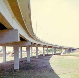
A colour photograph of the Nairn Overpass from below.
Metropolitan Corporation of Greater Winnipeg (Man.). Information Officer

Northdale Shopping Centre panorama
View of Northdale Shopping Centre, 963 Henderson Highway, 7.65 acres. From left to right: Loblaws Groceteria, Zeller's County Fair, various shops, the Royal Bank, the Canadian Imperial Bank of Commerce, A & P Food Store, Lord Wolseley School. Consists of 3 separate photographs pasted together on cardboard to create a panorama. The cardboard is a scrap made from an old sign of the Metropolitan Corporation of Greater Winnipeg (visible on the reverse). The cardboard is numbered “1”, presumably as part of a compilation with other shopping centre panoramas.
Metropolitan Corporation of Greater Winnipeg (Man.). Planning Division

Crossroads Shopping Centre panorama
View of Crossroads Shopping Centre, 1580 Regent Avenue W., 18 acres. From left to right: Woolco Department Store, Various shops, Safeway, Pacific 66 Gas Bar. Consists of 3 separate photographs pasted together on cardboard to create a panorama. The cardboard is a scrap made from an old sign of the Metropolitan Corporation of Greater Winnipeg (visible on the reverse). The cardboard is numbered “3”, presumably as part of a compilation with other shopping centre panoramas.
Metropolitan Corporation of Greater Winnipeg (Man.). Planning Division

Clark’s Department Store at Highway 59 panorama
View of Clarks at Highway 59, southwest corner of Panet Road and Nairn Avenue, 8.5 acres. From left to right: B/A gas bar, Loblaws, Clarks Discount Store and Auto Centre, B/A gas bar, Kavanaugh's Hamburgers. Consists of 3 separate photographs pasted together on cardboard to create a panorama. The cardboard is a scrap made from an old sign of the Metropolitan Corporation of Greater Winnipeg (visible on the reverse). The cardboard is numbered “4”, presumably as part of a compilation with other shopping centre panoramas.
Metropolitan Corporation of Greater Winnipeg (Man.). Planning Division

Grant Plaza Shopping Centre panorama
View of Grant Park Plaza Shopping Centre, 1200-1216 Grant Avenue, 13.2 acres. From left to right: Clarks Discount Store, Dominion Store, Liquor Commission, Clarks Auto Centre. Consists of 3 separate photographs pasted together on cardboard to create a panorama. The cardboard is a scrap made from an old sign of the Metropolitan Corporation of Greater Winnipeg (visible on the reverse). The cardboard is numbered “8”, presumably as part of a compilation with other shopping centre panoramas.
Metropolitan Corporation of Greater Winnipeg (Man.). Planning Division

Crestview Shopping Centre panorama
View of Crestview Shopping Centre, 3395 Portage Avenue, 8.3 acres. From left to right: Kmart Department Store, Dominion Store, Various Shops. Consists of 3 separate photographs pasted together on cardboard to create a panorama. The cardboard is a scrap made from an old sign of the Metropolitan Corporation of Greater Winnipeg (visible on the reverse). The cardboard is numbered “9”, presumably as part of a compilation with other shopping centre panoramas.
Metropolitan Corporation of Greater Winnipeg (Man.). Planning Division

Northgate Shopping Centre panorama
View of Northgate Plaza Shopping Centre, 1375-1425 McPhillips Street, 15 acres. From left to right: Clarks Discount Store, Various Shops, Northgate Bowling Lanes, Loblaw's. Consists of 3 separate photographs pasted together on cardboard to create a panorama. The cardboard is a scrap made from an old sign of the Metropolitan Corporation of Greater Winnipeg (visible on the reverse). The cardboard is numbered “14”, presumably as part of a compilation with other shopping centre panoramas.
Metropolitan Corporation of Greater Winnipeg (Man.). Planning Division

Polo Park Shopping Centre panorama
View of Polo Park Shopping Centre, 1485 Portage Avenue, 41 acres. West side of shopping centre, north side of Portage Avenue between Empress Street and St. James Street. Left to Right: Winnipeg Stadium, Winnipeg Arena, Loblaws, Simpson Sears Marina, Simpson Sears Garden Shop, Simpson Sears Department Store, Simpson Sears Service Station. Consists of 4 separate photographs pasted together on cardboard to create a panorama. The cardboard is a scrap made from an old sign of the Metropolitan Corporation of Greater Winnipeg (visible on the reverse). The cardboard is numbered “11”, presumably as part of a compilation with other shopping centre panoramas.
Metropolitan Corporation of Greater Winnipeg (Man.). Planning Division

Polo Park Shopping Centre panorama
View of Polo Park Shopping Centre, 1485 Portage Avenue, 41 acres. East side of shopping centre. From left to right: the Pancake House, Simpsons-Sears, Perth's Dry Cleaners, Genser's Furniture, Daytons, Jack and Jill, Reward, Gordi's Restaurant, Ricki’s, addition to shopping centre under construction, Dominion Store, CJAY-TV Station (CKY-TV), Winnipeg Arena. Consists of 4 separate photographs pasted together on cardboard to create a panorama. The cardboard is a scrap made from an old sign of the Metropolitan Corporation of Greater Winnipeg (visible on the reverse). The cardboard is numbered “12”, presumably as part of a compilation with other shopping centre panoramas.
Metropolitan Corporation of Greater Winnipeg (Man.). Planning Division
Photographs of the Nairn Overpass, including its construction and dedication.
Metropolitan Corporation of Greater Winnipeg (Man.). Information Officer

Southdale Shopping Centre panorama
View of Southdale Shopping Centre, 35 Lakewood Boulevard, 12.8 acres. From left to right: Dominion Store, Canadian Imperial Bank of Commerce, Mall Entrance, Quintons, Ebbeling Pharmacy, Kmart Department Store. Consists of 3 separate photographs pasted together on cardboard to create a panorama. The cardboard is a scrap made from an old sign of the Metropolitan Corporation of Greater Winnipeg (visible on the reverse). The cardboard is numbered “5”, presumably as part of a compilation with other shopping centre panoramas.
Metropolitan Corporation of Greater Winnipeg (Man.). Planning Division

Polo Park Shopping Centre panorama
View of Polo Park Shopping Centre, 1485 Portage Avenue, 41 acres. South side of shopping centre. Left to right: Winnipeg Motor Products, Motor Club, Simpson Sears Service Station, Simpson Sears Department Store. Consists of 3 separate photographs pasted together on cardboard to create a panorama. The cardboard is a scrap made from an old sign of the Metropolitan Corporation of Greater Winnipeg (visible on the reverse). The cardboard is numbered “13”, presumably as part of a compilation with other shopping centre panoramas.
Metropolitan Corporation of Greater Winnipeg (Man.). Planning Division
Chataway Pumping Station.
Winnipeg (Man.). Parks and Recreation Department
Series consists of a scrapbook commemorating the opening of the Grace hospital, a photograph collage of Winnipeg recreation spaces, and large photographs of Parks Board employees.